Berlingen (Eifel)
| coat of arms | Germany map | |
|---|---|---|

|
Coordinates: 50 ° 14 ' N , 6 ° 43' E |
|
| Basic data | ||
| State : | Rhineland-Palatinate | |
| County : | Vulkaneifel | |
| Association municipality : | Gerolstein | |
| Height : | 475 m above sea level NHN | |
| Area : | 3.59 km 2 | |
| Residents: | 224 (Dec. 31, 2019) | |
| Population density : | 62 inhabitants per km 2 | |
| Postal code : | 54570 | |
| Area code : | 06591 | |
| License plate : | DAU | |
| Community key : | 07 2 33 004 | |
| Association administration address: | Kyllweg 1 54568 Gerolstein |
|
| Website : | ||
| Local Mayor : | Erwin Schüller | |
| Location of the Berlingen community in the Vulkaneifel district | ||
Berlingen is a municipality in the Vulkaneifel district in Rhineland-Palatinate . It belongs to the Gerolstein community .
geography
Berlingen is located in the Eastern Eifel ( Vulkaneifel ) about five kilometers northeast of Gerolstein . The Berlinger Bach, a tributary of the Kyll, flows through the village .
The Weilerhof residential area also belongs to Berlingen .
The neighboring communities are Hohenfels-Essingen , Hinterweiler , Kirchweiler , Gerolstein , Pelm and Rockeskyll .
history
Berlingen was first mentioned in 1201 as the seat of a knight family. Ritter von Berlingen and his wife gave the Himmerod monastery their goods between "Wilre" ( Kirchweiler ) and "Fincroth" (Finkenroth, desert between Kirchweiler and Neroth ).
According to the Trier fire book , Berlingen had eight fireplaces in 1563 and six in 1684 . Until the late 18th century, the place belonged country wonderfully for electorate Trier and shelter as part of the centering Kirchweiler in court Rockeskyll the administration of the office down . In 1787 Berlingen had 86 inhabitants.
After the annexation of the Left Bank of the Rhine in the First Coalition War (1794), Berlingen belonged to the canton of Gerolstein in the Saar department from 1798 to 1814 .
Because of the agreements made at the Congress of Vienna (1815), a. the Eifel part of the Saar department to the Kingdom of Prussia . Under the Prussian administration Berlingen belonged to the mayor Rockeskyll in 1816 newly built circle down the administrative district of Trier , who from 1822 to part of the Rhine province was.
After the First World War , the area belonged to the French part of the Allied occupation of the Rhineland . After the Second World War , Berlingen became part of the then newly formed state of Rhineland-Palatinate within the French occupation zone .
- Population development
The development of the population of Berlingen, the values from 1871 to 1987 are based on censuses:
|
|
politics
Municipal council
The local council in Berlingen consists of six council members, who were elected by a majority vote in the local elections on May 26, 2019 , and the honorary local mayor as chairman.
coat of arms
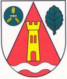
| Blazon : "In silver an inserted red tip, inside a golden tin tower above a lowered silver corrugated strip, in front a green millstone, covered with three golden ears, behind a green beech leaf." | |
Natural monuments
One of the sights is the Liberation Beech on the Alter Voss mountain ( 588 m above sea level ) (location) . From there there is also a beautiful view of the Vulkaneifel region .
The natural monument is under the number ND-7233-404 it is called "Summit of the old Voss with liberation beech north of Berlingen, Gewann Auf Alterfaß", extensive natural monument; therein: Fagus sylvatica, supposedly germinated before 1650; 34 m high with 3.15 m chest height and 20 m crown diameter.
Personalities
- Peter Kühn (* 1949 in Berlingen), Germanist, university professor for linguistics
See also
Web links
- Website of the Berlingen parish
- Short portrait of Berlingen ( memento from February 12, 2013 in the web archive archive.today ) on SWR television
- To search for cultural assets of the local community Berlingen in the database of cultural assets in the Trier region .
Individual evidence
- ↑ State Statistical Office of Rhineland-Palatinate - population status 2019, districts, communities, association communities ( help on this ).
- ↑ State Statistical Office Rhineland-Palatinate (ed.): Official directory of the municipalities and parts of the municipality. Status: January 2019 [ Version 2020 is available. ] . S. 113 (PDF; 3 MB).
- ^ Heinrich Beyer : Document book for the history of the Middle Rhine territories. Volume 2. Hölscher, Coblenz 1865, p. 229, certificate 190 ( Google Books ).
- ^ Wilhelm Fabricius : Explanations of the historical atlas of the Rhine province. Volume 2: The map of 1789. Bonn 1898, pp. 113, 149.
- ^ Georg Bärsch : Description of the government district of Trier: according to official sources ... Volume 2. Lintz, Trier 1846, p. 40 ( Google Books ).
- ↑ State Statistical Office Rhineland-Palatinate: My village, my city. Retrieved September 8, 2019 .
- ^ The Regional Returning Officer Rhineland-Palatinate: Local elections 2019, city and municipal council elections. Retrieved September 8, 2019 .
- ↑ Nature Conservation Administration Rhineland-Palatinate: Landscape Information System of the Nature Conservation Administration Rhineland-Palatinate ; Retrieved August 17, 2013


