Wallenborn
| coat of arms | Germany map | |
|---|---|---|

|
Coordinates: 50 ° 9 ' N , 6 ° 43' E |
|
| Basic data | ||
| State : | Rhineland-Palatinate | |
| County : | Vulkaneifel | |
| Association municipality : | Down | |
| Height : | 425 m above sea level NHN | |
| Area : | 8.23 km 2 | |
| Residents: | 416 (Dec. 31, 2019) | |
| Population density : | 51 inhabitants per km 2 | |
| Postal code : | 54570 | |
| Area code : | 06599 | |
| License plate : | DAU | |
| Community key : | 07 2 33 079 | |
| LOCODE : | DE WWX | |
| Association administration address: | Leopoldstrasse 29 54550 Daun |
|
| Website : | ||
| Local Mayor : | Günther Mehles | |
| Location of the local community of Wallenborn in the Vulkaneifel district | ||
Wallenborn is a municipality in the Vulkaneifel district in Rhineland-Palatinate . She belongs to the community of Daun .
geography
The place is in the Vulkaneifel approx. 10 km as the crow flies or 12 km by road southwest of Daun on the federal highway 257 .
history
The first mention of the place under the name "Wall Burne" found one a document dated 20 July 1225 in Gerhard von Blankenheim the Abbey Himmerod a piece donated piece affirms land.
Until the end of the 18th century, Wallenborn was an enclave in the Electorate of Manderscheid , but it was part of the imperial knighthood and belonged jointly to the Duke of Aremberg and Baron von Zandt.
- Population development
The development of the population of Wallenborn, the values from 1871 to 1987 are based on censuses:
|
|
politics
Municipal council
The council in Wallenborn consists of eight council members, who in the local elections on May 26, 2019 in a majority vote were elected, and the honorary mayor as chairman.
coat of arms
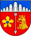
| Blazon : "Under a shield head, which is divided with nine arcs of blue and silver rising towards the center, a silver arrow turned downwards in red, in front accompanied by a golden medlar with blue tufts, behind by a golden, crowned lion head." | |
| Justification of the coat of arms: The nine arches rising towards the middle are supposed to symbolize the Wallenden Born , which gave the place its name. The silver arrow stands for the patron saint, St. Sebastian . Medlar and a crowned lion's head are reminiscent of two lords of Wallenborn: the Zandt von Merl , who had three crowned lions in their coat of arms, and the lord of Arenberg with three medlars in their coat of arms. |
Culture and sights
Cultural monuments
In Wallenborn there are some listed cultural monuments:
- Catholic branch church St. Sebastian: a hall from 1814, extended in 1951; In the churchyard there is a sandstone cross from 1684
- Way cross : made of red sandstone from the first half of the 17th century, it is a shaft cross of the so-called Kyllburg type, it can be found in the main street
- Crossroads with the year 162 [0]: in Weidenbacher Straße
- Wayside shrine: a wayside shrine with a stone relief of the fourteen helpers from 1812 is located in Weidenbacher Straße
Natural monuments
- Wallender Born : The main attraction of the village is a mofette called "Wallender Born", also popularly known as Brubbel , which has beendrilledinto an active cold water geyser . It erupts about every 30 minutes and can reach a height of 4 m.
traffic
- Road: Bundesstraße 257 runs past Wallenborn .
- Bus / train: Wallenborn is part of the Trier region . The bus line 523 of the Rhein-Mosel-Verkehrsgesellschaft offers some connections to the Gerolstein train station on the Eifel line from Cologne - Trier , as well as a daily connection to the city of Daun .
Web links
- Internet presence of the local community Wallenborn
- To search for cultural assets of the local community Wallenborn in the database of cultural assets in the Trier region .
- Gerhard Becker: Wallenborn - almost 800 years of village history. 1988 .
Individual evidence
- ↑ State Statistical Office of Rhineland-Palatinate - population status 2019, districts, communities, association communities ( help on this ).
- ^ Heinrich Beyer , Leopold Eltester , Adam Goerz: Document book on the history of the Middle Rhine territories: From the years 1212 to 1260 , Volume 3, Coblenz: Hölscher, 1874, p. 208 ( online )
- ^ Johann Friedrich Schannat , Georg Bärsch : Eiflia illustrata or geographical and historical description of the Eifel , Volume 3, Edition 2, Part 1, Mayer, 1854, p. 53 ( online )
- ↑ State Statistical Office Rhineland-Palatinate - regional data
- ^ The Regional Returning Officer Rhineland-Palatinate: Local elections 2019, city and municipal council elections
- ^ A b Friedbert Wißkirchen: New community coat of arms in the Daun district. In: Heimatjahrbuch 1990. Landkreis Vulkaneifel, accessed on April 6, 2019 .
- ↑ Zandt von Merl
- ↑ General Directorate for Cultural Heritage Rhineland-Palatinate (ed.): Informational directory of cultural monuments - Vulkaneifel district. Mainz 2020, p. 56 (PDF; 4.6 MB).
- ^ H. Wolfgang Wagner, Friederike Kremb-Wagner, Martin Koziol, Jörg FW Negendank: Trier and surroundings . Ed .: Peter Rothe (= collection of geological guides . Volume 60 ). 3. Edition. Gebr. Bornträger Verlagbuchhandlung, Stuttgart 2012, ISBN 978-3-443-15094-5 , p. 255-256 .


