
Kalenborn scrubbing
| coat of arms | Germany map | |
|---|---|---|

|
Coordinates: 50 ° 16 ' N , 6 ° 36' E |
|
| Basic data | ||
| State : | Rhineland-Palatinate | |
| County : | Vulkaneifel | |
| Association municipality : | Gerolstein | |
| Height : | 450 m above sea level NHN | |
| Area : | 7.34 km 2 | |
| Residents: | 371 (Dec 31, 2019) | |
| Population density : | 51 inhabitants per km 2 | |
| Postal code : | 54570 | |
| Area code : | 06591 | |
| License plate : | DAU | |
| Community key : | 07 2 33 036 | |
| Community structure: | 2 districts | |
| Association administration address: | Kyllweg 1 54568 Gerolstein |
|
| Website : | ||
| Local Mayor : | Rita Hoffmann | |
| Location of the local community Kalenborn-Schänen in the Vulkaneifel district | ||
  |
||

Kalenborn-Schänen in the Vulkaneifel is a municipality in the Vulkaneifel district in Rhineland-Palatinate . It belongs to the Gerolstein community .

Community structure
The districts are Kalenborn and Scheuert. The residential areas An der Acht, Birkenhof, In der Hillingswiese and Kammwiese also belong to the district of Kalenborn .
history
Kalenborn was first mentioned as de Caldebrunna in the Prümer Urbar in 893 .
The community Kalenborn was formed on June 7, 1969 from the previously independent communities Kalenborn and Scheuert. On December 1, 1969, the name was changed to Kalenborn-Schänen.
- Population development
The development of the population of Kalenborn-Schänen in relation to today's municipality, the values from 1871 to 1987 are based on censuses:
|
|
politics
Municipal council
The municipal council in Kalenborn-Schänen consists of eight council members, who were elected in a majority vote in the local elections on May 26, 2019 , and the honorary local mayor as chairman.
coat of arms
|
|
Blazon : “Divided by red through silver; above three golden fan-shaped ears of wheat, below a blue draw well. " |
|
Justification of the coat of arms: The three golden ears of wheat in the upper part of the coat of arms symbolize the name of the district of Schänen. With other neighboring towns, the Prüm monastery was liable to pay taxes; The monastery tithe barn was in Schubbing. The place name is derived from this tithe barn ("Scheuer" means "barn" in the Eifel dialect).
In addition, the ears of corn also indicate agriculture as a livelihood over centuries and the rural structure of the double community. Kalenborn was first mentioned in 846 as "Caldebrunna" among the possessions of the Prüm Abbey. The place name means: "cold well" or "cool spring". As a symbol for the place name of the district Kalenborn, the blue draw well was added in the lower part of the coat of arms. |
Culture and sights
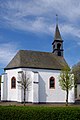
Kalenborn Chapel

Column altar (17th century)
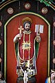
St. Ignatius

St. Wendelinus

Chapel scrubbing

Sanctuary

Star rib vault
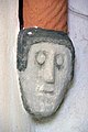
Console figure
.jpg)
_13.jpg)
_17.jpg)
_18.jpg)
_06.jpg)
_08.jpg)
_22.jpg)
_13.jpg)
See also: List of cultural monuments in Kalenborn-Schänen
traffic
Kalenborn-Schüsten is part of the Trier region . The community is served on weekdays by the bus line 522 of the Rhein-Mosel-Verkehrsgesellschaft , which connects the Doppeldorf with the nearest town Gerolstein and with Hillesheim . The nearest train station is Oberbettingen- Hilesheim on the Eifel route Cologne - Trier , about five kilometers to the northeast.
The B 410 Prüm - Mayen is about six kilometers south, the B 421 Stadtkyll - Daun just as far to the northeast. The next motorway junction is Prüm on the A 60 , about 20 kilometers south-west.
Web links
- Internet presence of the local community Kalenborn-Schänen
- School chronicle Kalenborn by Peter Leuschen, 2016
- To search for cultural goods of the local community Kalenborn-Schänen in the database of cultural goods in the Trier region .
Individual evidence
- ↑ a b State Statistical Office of Rhineland-Palatinate - population status 2019, districts, municipalities, association communities ( help on this ).
- ↑ State Statistical Office Rhineland-Palatinate (ed.): Official directory of the municipalities and parts of the municipality. Status: January 2019 [ Version 2020 is available. ] . S. 114 (PDF; 3 MB).
- ↑ Official municipality directory (= State Statistical Office of Rhineland-Palatinate [Hrsg.]: Statistical volumes . Volume 407 ). Bad Ems February 2016, p. 167 (PDF; 2.8 MB).
- ↑ Official municipality directory (= State Statistical Office of Rhineland-Palatinate [Hrsg.]: Statistical volumes . Volume 407 ). Bad Ems February 2016, p. 191 (PDF; 2.8 MB).
- ↑ State Statistical Office Rhineland-Palatinate - regional data
- ^ The Regional Returning Officer Rhineland-Palatinate: Local elections 2019, city and municipal council elections.
- ↑ Declaration of the coat of arms. (PDF) Retrieved May 27, 2019 .

Arbach | Basberg | Beinhausen | Bereborn | Berenbach | Berlingen | Berndorf | Betteldorf | Birgel | Birresborn | Bleckhausen | Bodenbach | Bongard | Borler | Boxberg | Brockscheid | Brückal | Darscheid | Down | Demerath | Densborn | Deudesfeld | Dockweiler | Dohm-Lammersdorf | Drees | Dreis-Brück | Duppach | Ellscheid | Esch | Feusdorf | Gefell | Gelenberg | Gerolstein | Gillenfeld | Gönnersdorf | Gunderath | Reverberation | Hillesheim | Hinterweiler | Höchstberg | Hohenfels-Essingen | Horperath | Hörscheid | Hörschhausen | Immerath | Jünkerath | Kalenborn scrubbing | Caperich | Katzwinkel | Kelberg | Kerpen (Eifel) | Kerschenbach | Kirchweiler | Kirsbach | Kolverath | Kopp | Kötterichen | Kradenbach | Lirstal | Lissendorf | Mannebach | More | Meisburg | Mosbruch | Mosquitoes | Mürlenbach | Neichen | Nerd | Neroth | Niederstadtfeld | Nitz | Nohn | Oberbettingen | Oberehe-Stroheich | Oberelz | Oberstadtfeld | Ormont | Pelm | Reimerath | Retterath | Reuth | Rockeskyll | Salm | Sarmersbach | Sassen | Saxler | Schalkenmehren | Scheid | Schönbach | Schüller | Protection | Stadtkyll | Steffeln | Steineberg | Steiningen | Strohn | Strotzbüsch | Üdersdorf | Udler | Uersfeld | Ueß | Utzerath | Üxheim | Wallenborn | Walsdorf | Weidenbach | Which council | Wiesbaum | Winkel (Eifel)