
Boxberg (Eifel)
| coat of arms | Germany map | |
|---|---|---|

|
Coordinates: 50 ° 17 ' N , 6 ° 53' E |
|
| Basic data | ||
| State : | Rhineland-Palatinate | |
| County : | Vulkaneifel | |
| Association municipality : | Kelberg | |
| Height : | 560 m above sea level NHN | |
| Area : | 5.64 km 2 | |
| Residents: | 234 (Dec. 31, 2019) | |
| Population density : | 41 inhabitants per km 2 | |
| Postal code : | 54552 | |
| Area code : | 02692 | |
| License plate : | DAU | |
| Community key : | 07 2 33 010 | |
| Association administration address: | Dauner Strasse 22 53539 Kelberg |
|
| Website : | ||
| Local Mayor : | Harald Fell | |
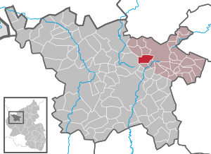
| Location of the local community Boxberg in the Vulkaneifel district | ||
  |
||

Boxberg is a municipality in the Vulkaneifel district in Rhineland-Palatinate . It belongs to the association community Kelberg . The Lieser rises in Boxberg .
history
Until the end of the 18th century the place belonged to the Electorate of Daun . The Niederehe monastery owned land in Boxberg, which was auctioned off under the French government. Boxberg was a municipality in the mayor's office of Sarmersbach under Prussian administration . In the course of the administrative reform in 1970 Boxberg was assigned to the Kelberg Association.
- Population development
The development of the population of Boxberg, the values from 1871 to 1987 are based on censuses:
|
|
religion
About 90% of the citizens of Boxberg are Roman Catholic and belong to the Catholic parish of St. Hubertus Beinhausen with the Hilgerath parish church.
politics
Municipal council
The municipal council in Boxberg consists of six council members, who were elected by a majority vote in the local elections on May 26, 2019 , and the honorary local mayor as chairman.
coat of arms
Boxberg's coat of arms contains a blue, oblique, wavy bar in silver. At the top there is a red wheel and at the bottom a red, diagonally upright sword.
_St._Katharina6354.JPG)
The oblique wavy bar should point out the Lieser . The red wheel in the upper part stands for the patroness of the town's chapel, Saint Catherine of Alexandria . The sword is a symbol for the Electoral Trier place of execution, which used to stand on today's Schillberg .
Transportation
Since December 8, 2018, the municipality of Boxberg has had good connections to local public transport for the first time . This was made possible by the new public transport concept RLP Nord. According to this concept, the public transport connections will be gradually increased throughout the north of Rhineland-Palatinate . The 520 bus connects Boxberg with new vehicles every hour (Saturday and Sunday every two hours) to the district town of Daun and the municipality of Kelberg (with stops in Neichen , Kradenbach , the industrial area and the Rengen district ).
In the center of town there is the Tannenstraße stop, which is also a transfer point between line 520 from / to Daun and the RufBus line 509.
In addition, the surrounding communities are also connected to local public transport Monday to Sunday at least every 2 hours by so-called on-call buses.
Line 509 runs every two hours from Borler to Kelberg, Monday to Sunday. On the way, the places Bongard, Bodenbach, Gelenberg and Boxberg are also approached. The line has two different routes. While one route runs from Borler via Bongard and Boxberg to Kelberg, the buses on the other run from Borler via Bodenbach, Gelenberg and Boxberg to Kelberg.
Web links
- Local community Boxberg on the website of the association community Kelberg
- To search for cultural assets of the local community Boxberg in the database of cultural assets in the Trier region .
- Brief portrait of Boxberg on SWR television
- Private page about Boxberg
Individual evidence
- ↑ State Statistical Office of Rhineland-Palatinate - population status 2019, districts, communities, association communities ( help on this ).
- ↑ State Statistical Office Rhineland-Palatinate - regional data
- ^ The Regional Returning Officer Rhineland-Palatinate: Local elections 2019, city and municipal council elections
- ↑ New bus concept for the Eastern Volcanic Eifel. Verkehrsverbund Region Trier, accessed on May 15, 2019 .

Arbach | Basberg | Beinhausen | Bereborn | Berenbach | Berlingen | Berndorf | Betteldorf | Birgel | Birresborn | Bleckhausen | Bodenbach | Bongard | Borler | Boxberg | Brockscheid | Brückal | Darscheid | Down | Demerath | Densborn | Deudesfeld | Dockweiler | Dohm-Lammersdorf | Drees | Dreis-Brück | Duppach | Ellscheid | Esch | Feusdorf | Gefell | Gelenberg | Gerolstein | Gillenfeld | Gönnersdorf | Gunderath | Reverberation | Hillesheim | Hinterweiler | Höchstberg | Hohenfels-Essingen | Horperath | Hörscheid | Hörschhausen | Immerath | Jünkerath | Kalenborn scrubbing | Caperich | Katzwinkel | Kelberg | Kerpen (Eifel) | Kerschenbach | Kirchweiler | Kirsbach | Kolverath | Kopp | Kötterichen | Kradenbach | Lirstal | Lissendorf | Mannebach | More | Meisburg | Mosbruch | Mosquitoes | Mürlenbach | Neichen | Nerd | Neroth | Niederstadtfeld | Nitz | Nohn | Oberbettingen | Oberehe-Stroheich | Oberelz | Oberstadtfeld | Ormont | Pelm | Reimerath | Retterath | Reuth | Rockeskyll | Salm | Sarmersbach | Sassen | Saxler | Schalkenmehren | Scheid | Schönbach | Schüller | Protection | Stadtkyll | Steffeln | Steineberg | Steiningen | Strohn | Strotzbüsch | Üdersdorf | Udler | Uersfeld | Ueß | Utzerath | Üxheim | Wallenborn | Walsdorf | Weidenbach | Which council | Wiesbaum | Winkel (Eifel)