
Ueß
| coat of arms | Germany map | |
|---|---|---|

|
Coordinates: 50 ° 15 ' N , 6 ° 56' E |
|
| Basic data | ||
| State : | Rhineland-Palatinate | |
| County : | Vulkaneifel | |
| Association municipality : | Kelberg | |
| Height : | 495 m above sea level NHN | |
| Area : | 1.49 km 2 | |
| Residents: | 41 (Dec. 31, 2019) | |
| Population density : | 28 inhabitants per km 2 | |
| Postal code : | 56767 | |
| Area code : | 02692 | |
| License plate : | DAU | |
| Community key : | 07 2 33 243 | |
| Association administration address: | Dauner Strasse 22 53539 Kelberg |
|
| Website : | ||
| Local Mayor : | Achim Maas | |
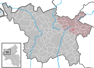
| Location of the local community Ueß in the Vulkaneifel district | ||
  |
||


Ueß is a municipality in the Vulkaneifel district in Rhineland-Palatinate . It belongs to the association community Kelberg .
Geographical location
The place is located in the Vulkaneifel nature park on the Üßbach and also exactly between Mosbruch and Hörschhausen .
history
Ueß belonged to the office of Nürburg in the Electorate of Cologne until the end of the 18th century .
- Population development
The development of the population, the values from 1871 to 1987 are based on censuses:
|
|
politics
Municipal council
The council in Ueß consists of six council members, who in the local elections on May 26, 2019 in a majority vote were elected, and the honorary mayor as chairman.
coat of arms
The description of the coat of arms reads: "A silver church tower with a golden roof is growing under a corrugated shield head in black, which is divided by a tin cut from red and silver."
See also
Web links
- Local community Ueß on the pages of the association community Kelberg
- To search for cultural assets of the local community Ueß in the database of cultural assets in the Trier region .
Individual evidence
- ↑ State Statistical Office of Rhineland-Palatinate - population status 2019, districts, communities, association communities ( help on this ).
- ↑ State Statistical Office Rhineland-Palatinate - regional data
- ^ The Regional Returning Officer Rhineland-Palatinate: Local elections 2019, city and municipal council elections

Arbach | Basberg | Beinhausen | Bereborn | Berenbach | Berlingen | Berndorf | Betteldorf | Birgel | Birresborn | Bleckhausen | Bodenbach | Bongard | Borler | Boxberg | Brockscheid | Brückal | Darscheid | Down | Demerath | Densborn | Deudesfeld | Dockweiler | Dohm-Lammersdorf | Drees | Dreis-Brück | Duppach | Ellscheid | Esch | Feusdorf | Gefell | Gelenberg | Gerolstein | Gillenfeld | Gönnersdorf | Gunderath | Reverberation | Hillesheim | Hinterweiler | Höchstberg | Hohenfels-Essingen | Horperath | Hörscheid | Hörschhausen | Immerath | Jünkerath | Kalenborn scrubbing | Caperich | Katzwinkel | Kelberg | Kerpen (Eifel) | Kerschenbach | Kirchweiler | Kirsbach | Kolverath | Kopp | Kötterichen | Kradenbach | Lirstal | Lissendorf | Mannebach | More | Meisburg | Mosbruch | Mosquitoes | Mürlenbach | Neichen | Nerd | Neroth | Niederstadtfeld | Nitz | Nohn | Oberbettingen | Oberehe-Stroheich | Oberelz | Oberstadtfeld | Ormont | Pelm | Reimerath | Retterath | Reuth | Rockeskyll | Salm | Sarmersbach | Sassen | Saxler | Schalkenmehren | Scheid | Schönbach | Schüller | Protection | Stadtkyll | Steffeln | Steineberg | Steiningen | Strohn | Strotzbüsch | Üdersdorf | Udler | Uersfeld | Ueß | Utzerath | Üxheim | Wallenborn | Walsdorf | Weidenbach | Which council | Wiesbaum | Winkel (Eifel)