
Federal motorway 48
| Bundesautobahn 48 in Germany | ||||||||||||||||||||||||||||||||||||||||||||||||||||||||||||||||||||||||||||||||||||||||||||||||||||

|
||||||||||||||||||||||||||||||||||||||||||||||||||||||||||||||||||||||||||||||||||||||||||||||||||||
| |
||||||||||||||||||||||||||||||||||||||||||||||||||||||||||||||||||||||||||||||||||||||||||||||||||||
| map | ||||||||||||||||||||||||||||||||||||||||||||||||||||||||||||||||||||||||||||||||||||||||||||||||||||
 |
||||||||||||||||||||||||||||||||||||||||||||||||||||||||||||||||||||||||||||||||||||||||||||||||||||
| Basic data | ||||||||||||||||||||||||||||||||||||||||||||||||||||||||||||||||||||||||||||||||||||||||||||||||||||
| Operator: |
|
|||||||||||||||||||||||||||||||||||||||||||||||||||||||||||||||||||||||||||||||||||||||||||||||||||
| Start of the street: |
Vulkaneifel motorway triangle ( 50 ° 11 ′ N , 6 ° 54 ′ E ) |
|||||||||||||||||||||||||||||||||||||||||||||||||||||||||||||||||||||||||||||||||||||||||||||||||||
| End of street: |
Autobahn triangle Dernbach ( 50 ° 28 ′ N , 7 ° 46 ′ E ) |
|||||||||||||||||||||||||||||||||||||||||||||||||||||||||||||||||||||||||||||||||||||||||||||||||||
| Overall length: | 78 km | |||||||||||||||||||||||||||||||||||||||||||||||||||||||||||||||||||||||||||||||||||||||||||||||||||
|
State : |
||||||||||||||||||||||||||||||||||||||||||||||||||||||||||||||||||||||||||||||||||||||||||||||||||||
 |
||||||||||||||||||||||||||||||||||||||||||||||||||||||||||||||||||||||||||||||||||||||||||||||||||||
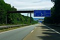
| BAB 48 near Koblenz | ||||||||||||||||||||||||||||||||||||||||||||||||||||||||||||||||||||||||||||||||||||||||||||||||||||
|
Course of the road
|
||||||||||||||||||||||||||||||||||||||||||||||||||||||||||||||||||||||||||||||||||||||||||||||||||||
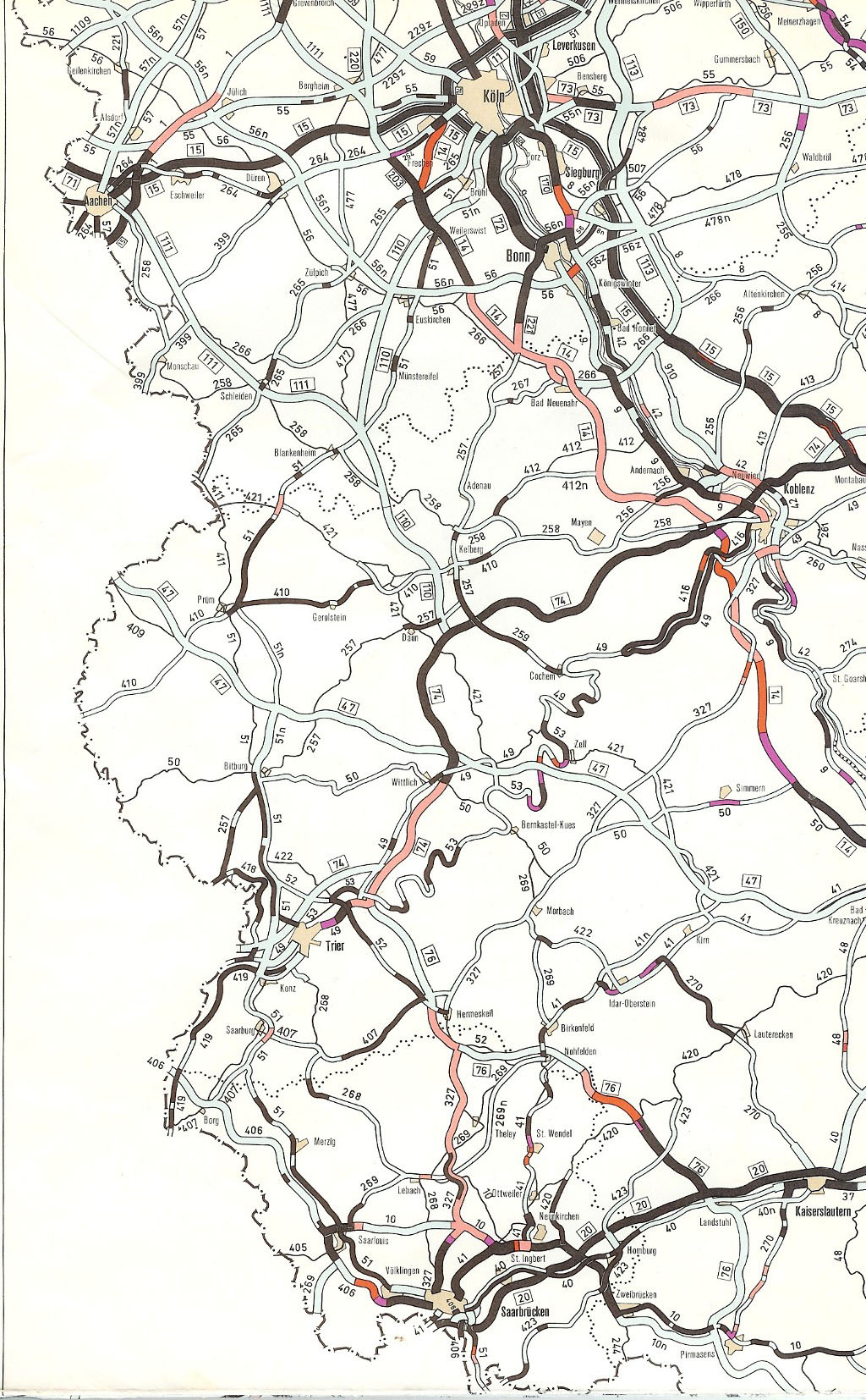
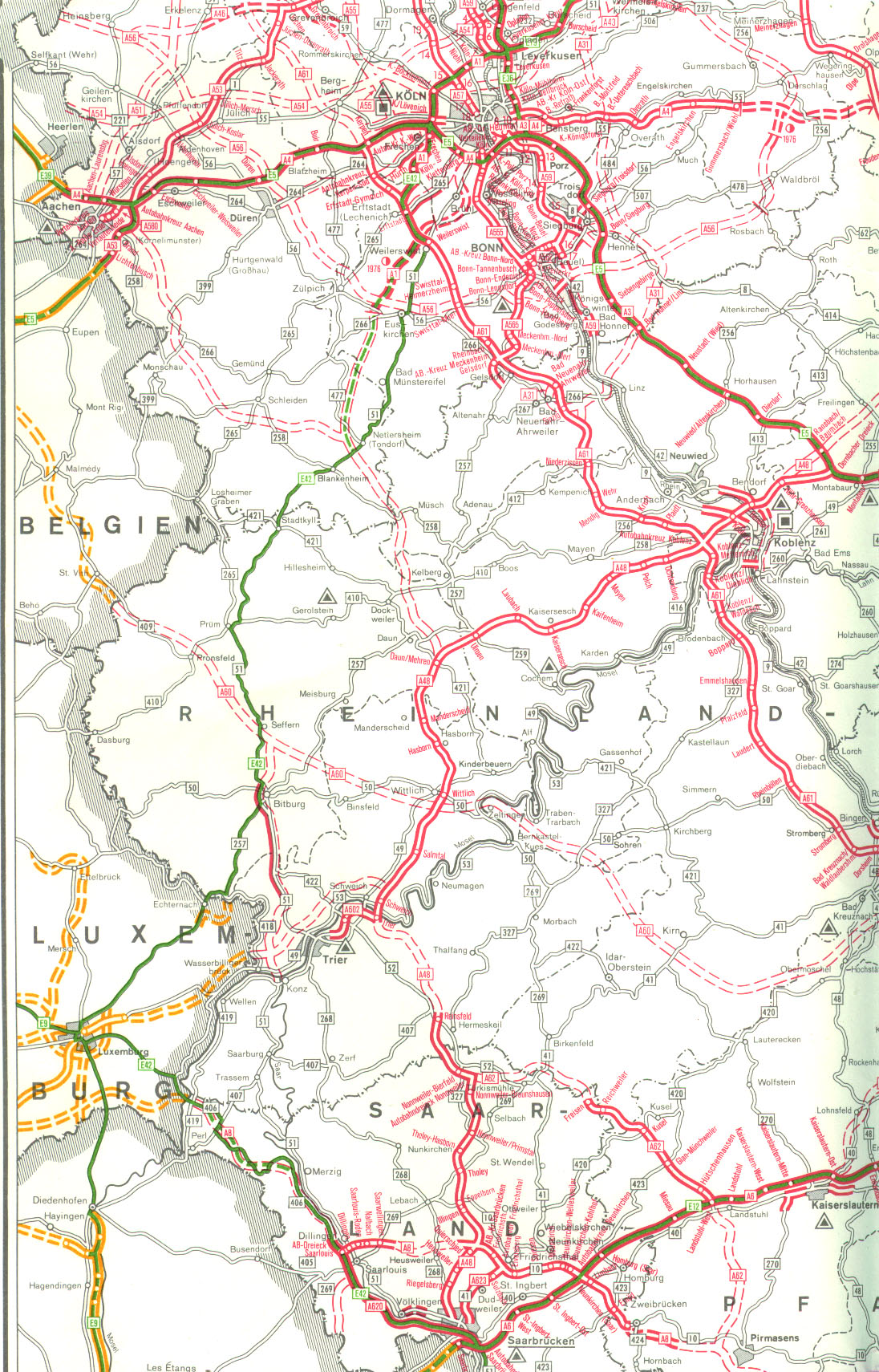
The federal autobahn 48 (abbreviation: BAB 48 ) - short form: Autobahn 48 (abbreviation: A 48 ) - is a German autobahn in the state of Rhineland-Palatinate , which branches off the autobahn 1 at the Vulkaneifel triangle near Daun and from there via Koblenz to the Dernbach triangle in the Westerwald , where it joins the federal highway 3 . It opens up large parts of the Eifel and the region around Trier with the Rhineland and is part of the European route 44 along its entire length .
course
The BAB 48 begins at the Vulkaneifel motorway triangle, where it branches off from the BAB 1. Since the latter ends just a few kilometers north of the triangle at Kelberg and there is an approximately 20 km long gap in the direction of Cologne , traffic from Trier continues in the direction of Cologne via the BAB 48 and later the BAB 61 . After the triangle, there is a hilly course with some uphill and downhill stretches through the wooded and hilly Vulkaneifel , directly past the Ulmener Maar . The route consisting of long straights and isolated, relatively narrow curves is characteristic. At Kaisersesch you leave the hilly Eifel section and reach the Maifeld plain . Shortly before Mayen , the motorway crosses the deeply cut valley of the Elzbach . Immediately north of the 97 m high Elztal bridge is a rest area with a gas station. Via the Mayen junction, the route to the BAB 61 ( Mendig junction ) can be shortened by driving on federal highway 262 , which eliminates the detour via the Koblenz motorway junction .
Behind Mayen there is a winding section before you leave the Maifeld and after Ochtendung the Middle Rhine Basin is reached in a downhill section . At the Koblenz junction, the BAB 48 crosses the BAB 61 ( Venlo - Ludwigshafen ), a few kilometers further on the Koblenz-Nord junction, which is also an unplanned intersection, connects to the B 9 , which as the main traffic artery of the Middle Rhine Valley connects the city center of Koblenz and the suburbs on the left bank of the Rhine ties up. The motorway then crosses the Rhine on the Bendorfer Bridge and creates a connection to the Koblenz districts on the right bank of the Rhine and the suburbs on the right bank of the Rhine via the Bendorf / Neuwied junction. Due to the lack of space, the junction is unusually constructed and basically consists of a combination of half a clover leaf and two trumpets.
Immediately afterwards, the BAB 48 follows a tight combination of curves and runs parallel to the Rhine up to the heights of the Westerwald , leaving the conurbation around Koblenz. In the westerly direction of travel there is a sweeping view of the Rhine Valley and the Koblenz-Neuwied Basin. At Höhr-Grenzhausen there is a small rest area in the eastern direction, but no refueling facility. After a few more kilometers across the hilly Westerwald landscape, the motorway finally joins the BAB 3 ( Emmerich - Cologne - Frankfurt am Main - Passau ) at the Dernbach triangle .

Start of the BAB 48 at the Vulkaneifel triangle

Elz Valley Bridge near Mayen
Descent to the Middle Rhine Valley or Koblenz-Neuwied Basin, shortly before the Koblenz motorway junction

Bendorfer Bridge over the Rhine

End of the Bendorfer bridge over the Rhine and start of the ascent to the Westerwald

Dernbach motorway triangle: junction with BAB 3


history
The current route of the BAB 48 was already present in the top network of long-distance road planning of the Weimar Republic and the time of National Socialism as part of a motorway from the Giessen area via Koblenz to Trier . Even before the outbreak of World War II , construction work for the line began on some sections, but was no longer completed. The route that exists today was built in the 1960s, initially as a new single-lane federal highway and later as a two-lane federal motorway. With the introduction of today's numbering system in 1975, the federal motorway 48 comprised the largely incomplete connection between the Luxembourg border, Trier, Koblenz, Gießen and Hattenbacher Dreieck . After the construction of the Koblenz – Gießen route was discontinued in the 1980s and junction numbering was introduced in 1992, the name BAB 48 was limited to the section between Daun and Dernbach that exists today. The remaining sections of the connection that were built received new numbers.
Time of National Socialism: Reichsautobahn construction
The network of the Reichsautobahn , which was essentially based on plans by the HaFraBa association in the 1920s and which the Nazis who came to power in January 1933 under the leadership of Adolf Hitler were intensively promoting, already included the route from the Reichsautobahn Cologne-Frankfurt (completed 1937 to 1940, today's BAB 3 ) to Koblenz and Trier. At the end of the 1930s, plans included a north-south route from Cologne via Trier to Landstuhl , in addition to the Cologne – Frankfurt route , which would connect there between Saarbrücken and Kaiserslautern to the Saarbrücken– Mannheim Reichsautobahn, which was also under construction at the time (today's BAB 6 ) should flow. During the construction of this motorway, preliminary work for a motorway triangle was realized. Between the routes Cologne – Landstuhl near Daun and Cologne – Frankfurt near Dernbach , a cross connection with a connection to Koblenz was planned, which was given operating route number 53.
The construction of this line was started, initially as a continuous connection Dernbach – Trier, on the sections Wittlich - Kaisersesch and Koblenz (connection Reichsstraße 9 - Dernbacher Dreieck ). The surveying work was carried out in 1937 and 1938, construction began in September 1939 at Hasborn after the land had been acquired quickly . During the construction, forced laborers from the Wittlich prison , the Hinzert concentration camp , Luxembourg, as well as Polish and Vosjet prisoners of war, who were interned in barracks along the way, were committed.
In addition to the extensive earthworks, 27 bridge structures were completely completed and a further 17 structures partially completed, 13.6 km of concrete carriageway between the village and Hasborn were already open to traffic. In the course of the Second World War, as on all construction sites on the Reichsautobahn, construction work was initially temporarily and finally stopped completely.
1950s and 1960s: resumption of planning and completion
After the end of the Second World War, work to complete the line between Koblenz and the Dernbacher Dreieck was resumed in 1954 in order to connect the Cologne – Frankfurt motorway to the city of Koblenz. The route was slightly modified in the vicinity of Koblenz-Bubenheim , so that the bridges that had already been completed there were not used and some of them have been preserved to this day as relics of the building of the Reichsautobahn. From 1959, plans were resumed for the continuation via Daun and Trier to Landstuhl. Here, in the northern part, the partially completed pre-war road was used, which was initially a single lane.
Construction on the Brexbachtal Bridge near Höhr-Grenzhausen, which had already begun before the war, continued from 1958 onwards, but the already completed pillars were demolished because the new bridge was to have a larger span. In December 1961 the first 11.8 km long section between the Dernbach triangle and a provisional connection to the L 307 west of Höhr-Grenzhausen was completed and opened to traffic. In March 1963, the continuation to the Bendorf / Neuwied junction on the B 42 was released. This clearance was initially made provisionally on the southern carriageway in order to relieve the urban area of Bendorf from through traffic. The northern carriageway in this area was not completed until October 1963. Characteristic of this section is the steep and winding descent from the Westerwald down to the Middle Rhine Valley, which is very wide open here, on the so-called Weitersburger slope.
The construction contract for the Rhine crossing between Bendorf and St. Sebastian was awarded in December 1961. Construction work on the bridge began in March 1962 and was completed after almost three and a half years of construction in August 1965, which extended the motorway to the Koblenz-Nord junction on the B 9 . The bridge structure is a total of 1029 m long and has a maximum span of 208 m, which at the time of its construction represented the largest span of all prestressed concrete girder bridges worldwide.
The Kaisersesch - Wittlich section between Koblenz and Trier was tackled in the early 1960s and completed with a one-way carriageway by 1967. The route was initially not run as a motorway, but as the B 408 . The section between Wittlich-Dorf and Hasborn, which was passable before the war but not released, was opened to traffic in a festive ceremony in 1964. A short section near Hasborn could only be released on July 1, 1968, because since 1950 the French army, as the occupying power, had been using and clearing an earthwork section as an ammunition depot.
In 1967 the B 408 was upgraded to a motorway and was given the name Autobahn 74 . At the same time, construction started between Koblenz and Kaisersesch and the second carriageway between Kaisersesch and Wittlich. The gap was closed in three construction phases in 1968 (Koblenz-Nord– Kreuz Koblenz ), 1969 ( Mayen – Kaiseresch) and 1970 (Kreuz Koblenz – Mayen) with two carriageways, the second carriageway to Wittlich was also finished in 1970. The two-lane expansion of the Kaisersesch – Wittlich section was largely driven by the Wittlich road construction department , which was newly established on October 1, 1968 . The most outstanding structure is the 97 m high Elz Valley Bridge at the eastern end of the section, which was completed in 1967. Thus there was a continuous, two-lane motorway between the triangle Dernbach and Wittlich.
1975: Introduction of motorway numbering

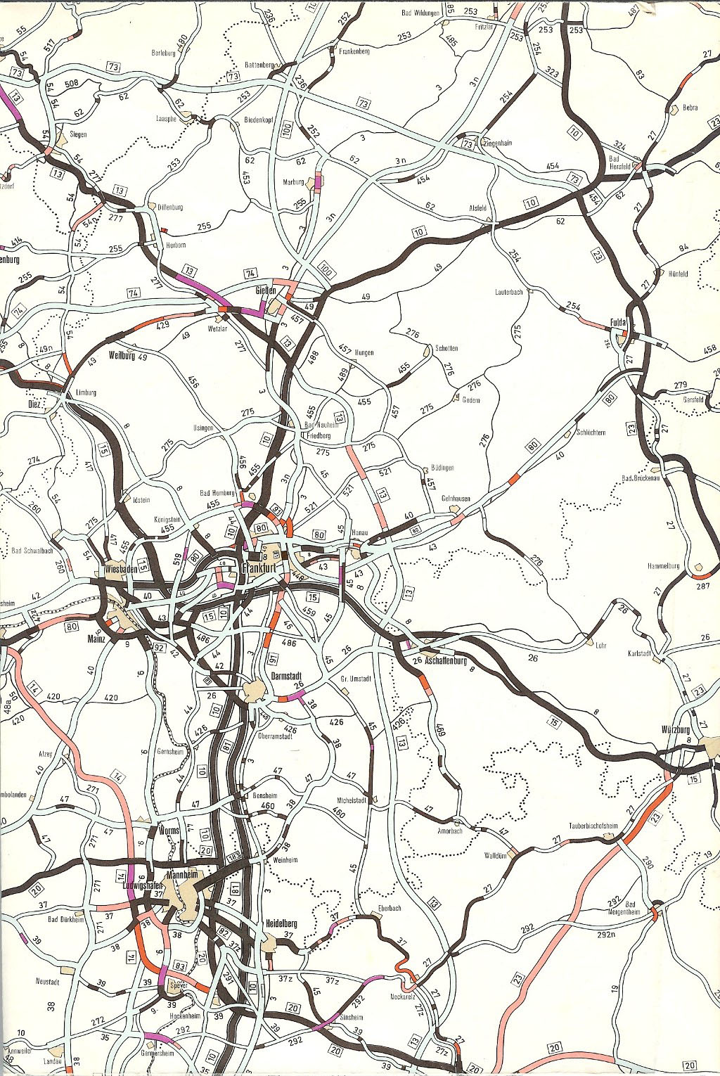
The plan drawn up in the early 1970s to expand federal highways from 1971 to 1985 provided for the first time under the internal name “Autobahn 74” a route from Luxembourg via Trier, Koblenz, Wetzlar and Gießen to the Reiskirchener Dreieck. With effect from January 1, 1975, the road was designated as Federal Motorway 48 (BAB 48 for short) from Daun (BAB 1) via Mayen , Koblenz (BAB 61), Höhr-Grenzhausen - Ransbach-Baumbach (BAB 3), Westerburg , Wetzlar ( BAB 45) , Gießen ( B 49 and BAB 5 ), Alsfeld to Hattenbach ( BAB 7 ). Since the route between the Moseltal motorway triangle and the Daun junction represented the joint route of the BAB 1 and the BAB 48, both motorways were indicated accordingly on the traffic signs in this section.
The plans for the motorway connection between the Hanseatic cities and Frankfurt and Basel ( HaFraBa ) in the 1920s initially envisaged a route from Kassel via Marburg to Gießen. The National Socialists modified the planning: the route was approved for construction as early as 1935 in the current tour, and it was completed in 1938. While this section was still referred to as "Autobahn 10" ( Hamburg - Basel) in the plan drawn up in the early 1970s to expand the federal highways from 1971 to 1985, this changed with the new network planning, which took effect on January 1st 1975 came into effect. According to this, a new route from Bremen to Gießen was planned for the BAB 5. The section between the Reiskirchener Dreieck and the Dreieck Hattenbach became part of the BAB 48 and designated accordingly.
Whereas in the second law of 25 August 1980 amending the law on the expansion of federal highways from 1971 to 1985 (Federal Law Gazette 1980, Part I, p. 1614) the route was still designated as BAB 48, the third law of April 21, 1986 to amend the law on the expansion of federal highways (Federal Law Gazette 1986, Part I, p. 557) this section as BAB 5. This was in the context of the task of motorway planning between Koblenz and Wetzlar (BAB 48) and Bremen and Gießen (BAB 5), which had already been implemented with the Second Amendment Act in 1980.
1992: Renumbering and route shortening
The introduction of junction numbering in 1992 brought some changes to the numbering of the motorway network. Longer stretches of road on which two federal motorways run over a common route should now be avoided. So far, this has also applied to the more than 40 km long section between the Daun / Mehren and Schweich junctions , which was run as BAB 1 / BAB 48. Remarkably, the BAB 48 continued in a northerly direction and eastwards from Daun, and BAB 1 in a southerly direction - there were motorway triangles at both number changes.
Since all junctions on this section would otherwise have been given two different numbers, the BAB 48 was shortened by the Luxembourg – Daun / Mehren route, as it contained a gap anyway (Trier north bypass). The section from Trier-Ehrang to the Luxembourg border was completed in two sections in 1984 and 1987 and was called BAB 64 from 1992 . The Daun / Mehren – Schweich route was added to the BAB 1 alone, and the number change was initially placed at the Daun / Mehren junction. In the mid-1990s, a motorway triangle was built during the excavation of the route in the 1950s for a motorway connection towards Cologne , including an approximately 3 km long section of the BAB 1 to the next Daun junction. The triangle had the working title of the Daun motorway triangle , which was then changed to the Vulkaneifel motorway triangle when it opened in 1997 . Since then it has marked the beginning of the BAB 48. The Daun / Mehren junction was renamed Mehren when the triangle was completed .
List of traffic clearances
The release of the individual sections of the route, which was designated as BAB 48 from January 1, 1975 (in light, the current section that has existed since 1992) took place:
| section | year | km | comment |
|---|---|---|---|
| Luxembourg border - AS Trier | 1987 | 8.7 km | since 1992 part of the BAB 64 |
| AS Trier - Ehrang (connection B 52) | 1981, 2011 | 4.9 km | initially only one lane, since 1992 part of the BAB 64 |
| (AD Moseltal -) AS Schweich - AS Salmtal | 1974 | 13.0 km | initially double numbering BAB 1 / BAB 48, since 1992 part of BAB 1 |
| AS Salmtal - AS Wittlich | 1975 | 10.2 km | initially double numbering BAB 1 / BAB 48, since 1992 part of BAB 1 |
| AS Wittlich - Dorf (connection B 49) | 1971 | 1.7 km | initially double numbering BAB 1 / BAB 48, since 1992 part of BAB 1 |
| Village - AS Hasborn | 1964, 1970 | 6.8 km | Opened as federal road B 408, upgraded to autobahn in 1967, only one lane until 1970, initially double numbering BAB 1 / BAB 48, since 1992 part of BAB 1 |
| AS Hasborn - AS Daun / Mehren | 1965, 1970 | 18.6 km | Opened as federal road B 408, upgraded to autobahn in 1967, only one lane until 1970, initially double numbering BAB 1 / BAB 48, since 1992 part of BAB 1 |
| AS Daun / Mehren - AS Kaisersesch | 1965, 1970 | 20.7 km | opened as federal highway B 408, upgraded to motorway in 1967, only one lane until 1970, since 1997 start of BAB 48 at AD Vulkaneifel |
| AS Kaisersesch - AS Mayen | 1969 | 13.0 km | |
| AS Mayen - AK Koblenz | 1970 | 21.0 km | |
| AK Koblenz - AS Koblenz-Nord | 1968 | 6.0 km | |
| AS Koblenz-Nord - AS Bendorf / Neuwied | 1965 | 3.3 km | |
| AS Bendorf / Neuwied - AS Höhr-Grenzhausen | 1963 | 4.8 km | southern carriageway in March 1963, northern in October 1963 |
| AS Höhr-Grenzhausen - AD Dernbach | 1961 | 11.0 km | |
| AS Aßlar - Hermannstein (connection B 277) | 1974 | 1.0 km | part of the BAB 480 since 1986 |
| Hermannstein (connection B 277) - Blasbach (connection L 3053) | 1971 | 3.0 km | Construction work in the course of the construction of the Wetzlarer Kreuz of the BAB 45, only one lane, since 1986 part of the BAB 480 |
| Biebertal (connection L 3047) - AS Wettenberg | 1981 | 2.1 km | only one lane, since 1986 part of the BAB 480 |
| AS Wettenberg - Giessener Nordkreuz | 1975 | 8.0 km | part of the BAB 480 since 1986 |
| Giessener Nordkreuz - Reiskirchener Dreieck | 1979 | 8.5 km | part of the BAB 480 since 1986 |
| (AS Fernwald -) Reiskirchener Dreieck - Hattenbacher Dreieck | 1938 | 59 km | since 1986 part of the BAB 5 |
Planning not carried out
Trier north bypass
The planning for the Trier northern bypass dates back to the 1960s. The plan drawn up in the early 1970s to expand the federal highways from 1971 to 1985 provided for a section under the internal name “Autobahn 74” from Luxembourg via Trier, Koblenz, Wetzlar and Gießen to the Reiskirchener Dreieck .
The Luxembourg - Trier - Mesenich - Ehrang - Föhren section was still planned as a new federal motorway in 1975, but not as the A 48. The Daun - Trier line was an exclusive part of the A 1 line.
In the network plan of January 1, 1976, the continuation of the A 48 from Daun via Trier to Saarbrücken instead of the A 1, which should end from Cologne at the Daun / Vulkaneifel triangle. The Trier northern bypass was therefore not yet planned as A 48 in January 1976.
This changed a few months later with the requirements plan of the law amending the law on the expansion of federal highways from August 5, 1976 from 1971 to 1985. The Trier northern bypass was now included as part of the A 48. The Daun - Saarbrücken route was designated exclusively as the A1.
With the second law amending the law on the expansion of federal highways from 1971 to 1985 from August 25, 1980, the Trier northern bypass remained in the requirement plan as part of the A 48. The double designation A 1 / A 48 was now included between Föhren and Daun. Closing the gap between Trier and the A1 near Schweich with a length of 10 kilometers was only included in stage II in the requirements plan of this law. Sections between Ehrang and the federal border were not completed until 1984 and 1987.
The third law amending the law on the expansion of federal highways of April 21, 1986 (Federal Law Gazette 1986, Part I, p. 557) did not include the route between Trier-Ehrang and the A 1 as an urgent requirement, nor as an additional one Planning.
In the requirement plan of the Fourth Act on the Amendment of the Long-Distance Road Expansion Act of November 15, 1993, the Trier northern bypass was again included in the requirement plan under the designation BAB 48 as a further requirement. After the reorganization of the motorway numbering in 1992, this part of the BAB 48 from the Luxembourg border to Trier was already renamed the BAB 64 . The requirements plan of the Fifth Act on the Amendment of the Highway Expansion Act of October 4, 2004 still contained the Trier northern bypass under the new name as BAB 64, but as a further requirement with an established high ecological risk.
Westerwald autobahn Koblenz – Gießen
The plans for the route between today's A3 and the Gießen area also go back to the end of the 1930s. The route designated as operating route no.56 was planned between Limburg an der Lahn and operating route no.55 Dortmund - Gießen in the Wetzlar area, with the Dortmund-Gießen line going north around Gießen to today's A 5 Hattenbacher Dreieck - Frankfurt (Main) should. The line was not built until the end of the Second World War.
It was not until the mid-1960s that maps of a connection between Koblenz and Giessen were mapped out. Initially, the pre-war planning was followed up with a line from Girod or Kleinholbach near Montabaur (A 3) via Hundsangen , Thalheim , Frickhofen , Lahr , Barig-Selbenhausen , Löhnberg , Bissenberg , Oberbiel , Wetzlar , Krofdorf-Gleiberg , Großen-Buseck to Reiskirchen intended.
Already at the end of the 1960s, this route was in favor of a line Höhr-Grenzhausen or Hilgert - Oberhaid (A 3) - Selters - Arnshöfen - Langenhahn - Hergenroth near Westerburg - Irmtraut - Probbach - Löhnberg - Bissenberg - Wetzlar - Krofdorf-Gleiberg - Großen- Buseck - Reiskirchen abandoned. The plan drawn up at the beginning of the 1970s to expand the federal trunk roads from 1971 to 1985 also included this section of the route under the internal name “Autobahn 74”.
In 1971 the spacious Wetzlarer Kreuz was opened to traffic. In 1975 and 1981, three sections between AS Wettenberg and the Reiskirchener Dreieck were completed. The rest of the route remained unfinished. With the second law of August 25, 1980 amending the law on the expansion of federal highways from 1971 to 1985 (Federal Law Gazette 1980, Part I, p. 1614), the Koblenz - Wetzlar route was no longer included in the requirement plan as A 48 . Instead, the construction of a federal road on the line Mogendorf (A 3) - Rothenbach ( Bundesstrasse 255 ) - Westerburg - Langendernbach - Waldbrunn (Westerwald) - Weilburg with a connection to the B 49 was planned, but only in Stage II. The B 49 should be between Wetzlar and Limburg an der Lahn are now being expanded to four lanes (stage I). The A 48 should be connected to the B 49 between the AS Aßlar and Wetzlar-Dalheim . The construction of the A 48 between the Wetzlarer Kreuz and AS Wettenberg / Biebertal was still planned, but only classified in Stage II.
The third law of April 21, 1986 amending the law on the expansion of federal highways (Federal Law Gazette 1986, Part I, p. 557) brought even more far-reaching cuts to the planning: the construction of the new federal highways between Rothenbach and Weilburg was canceled, what remained was another Only planning the Mogendorf - Rothenbach route with a connection to the B 255. The four-lane expansion between Wetzlar and Limburg an der Lahn was no longer an urgent requirement, but only included as a further plan. The connection of the A 48 from Asslar to the B 49 near Wetzlar-Dalheim was omitted without replacement. Only a single-lane new building was planned between the Wetzlarer Kreuz and Wettenberg. The route from AS Aßlar to the Reiskirchener Dreieck was rededicated as the A 480 .
In the course of drawing up the Federal Transport Infrastructure Plan in 2003, considerations for such a motorway connection ( Westerwald motorway ) were again raised . In particular, the FDP in Rhineland-Palatinate and at the same time coalition partner of the SPD demanded the construction of the A 48. In the federal traffic route plan, however, the A 48 was only included with the variant Mogendorf (A 3) - Siegen (A 45) (50.5 km) and beyond Needs with identified high ecological risk discontinued. There was immediate resistance in the region to the construction of the autobahn, which should run through Hachenburg and Betzdorf .
Instead, the state of Hesse is pushing ahead with the four-lane expansion of the B 49 between Wetzlar and Limburg an der Lahn.
State of development

With the completion of the second carriageway between Wittlich and Kaisersesch in 1970, both the section of the route now known as BAB 48 and the sections previously listed under this number were designed as a four-lane motorway with hard shoulder. The hard shoulder between the Bendorf / Neuwied junction and the Dernbach motorway triangle was subsequently re-marked as a third, additional lane, with the exception of a short distance east of the Höhr-Grenzhausen junction near the Brexbachtal bridge. There are therefore emergency bays at certain intervals, and because of this, some parking spaces do not have an acceleration lane and are only separated from the main carriageway by a stop sign (see picture).
In August 2019, the third lane in the direction of Koblenz was re-marked as a hard shoulder because, according to the responsible motorway office in Montabaur, the traffic volume is too low for a three-lane lane and the lack of deceleration and acceleration lanes to the Kannenbäckerland and Albrechtshof rest areas pose a safety risk.
Individual evidence
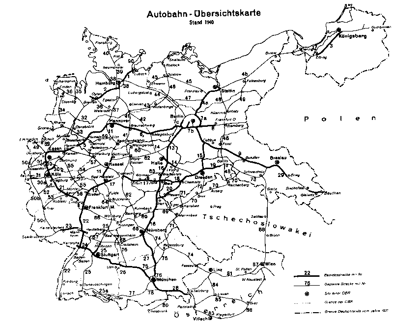
- ↑ Motorway overview map. Status: 1940. Accessed April 15, 2013 (map).
- ↑ a b Memories of a Sunken World: Page 77 , www.hasborn.de
- ^ A b Henning Maruhn: History of the A1 / A48 Saarbrücken - Trier - Koblenz. October 31, 1999, accessed April 15, 2013 (Internet contribution).
- ^ Archives for Motorway and Road History: Events of 1958. Retrieved April 5, 2020 .
- ^ Archives for Motorway and Road History: Events of 1961. Retrieved April 5, 2020 .
- ^ Archives for Motorway and Road History: Events of 1963. Retrieved April 5, 2020 .
- ^ Archives for Motorway and Road History: Events of 1963. Retrieved April 5, 2020 .
- ↑ Stories about the motorway construction near Hasborn , www.eifelzeitung.de
- ↑ Construction work on federal trunk roads in 1972. Expansion of federal trunk roads from 1971 to 1985. Annex to road construction report 1972. Federal Minister of Transport, Road Construction Department, accessed on April 15, 2013 (map excerpt).
- ↑ Construction work on federal trunk roads in 1972. Expansion of federal trunk roads from 1971 to 1985. Annex to road construction report 1972. Federal Minister of Transport, Road Construction Department, accessed on April 15, 2013 (map excerpt).
- ^ Structure and numbering of the federal highways. Planned overall network. Federal Minister of Transport, Road Construction Department, June 15, 1974, accessed on September 18, 2013 (map excerpt).
- ↑ Thomas Noßke: motorway construction in Germany. Prehistory and start of construction. 2008, accessed on April 15, 2013 (Internet contribution).
- ↑ Construction work on federal trunk roads in 1972. Expansion of federal trunk roads from 1971 to 1985. Annex to road construction report 1972. Federal Minister of Transport, Road Construction Department, accessed on April 15, 2013 (map excerpt).
- ↑ Network of federal motorways and federal highways. Status January 1, 1976. Federal Minister of Transport, Road Construction Department, accessed on March 31, 2013 (map excerpt).
- ↑ Construction work on federal trunk roads in 1972. Expansion of federal trunk roads from 1971 to 1985. Annex to road construction report 1972. Federal Minister of Transport, Road Construction Department, accessed on April 15, 2013 (map excerpt).
- ↑ Construction work on federal trunk roads in 1972. Expansion of federal trunk roads from 1971 to 1985. Annex to road construction report 1972. Federal Minister of Transport, Road Construction Department, accessed on April 15, 2013 (map excerpt).
- ^ Structure and numbering of the federal highways. Planned overall network. Federal Minister of Transport, Road Construction Department, June 15, 1974, accessed on September 18, 2013 (map excerpt).
- ↑ Network of federal motorways and federal highways. Status January 1, 1976. Federal Minister of Transport, Road Construction Department, accessed on March 31, 2013 (map excerpt).
- ↑ Federal Law Gazette, 1976, Part I, p. 2093
- ↑ Federal Law Gazette 1980, Part I, p. 1614
- ↑ Federal Law Gazette 1993, Part I, p. 1877
- ↑ Federal Law Gazette 2004, Part I, p. 2574
- ↑ Motorway overview map. Status: 1940. Accessed April 15, 2013 (map).
- ^ German general map, Mairs Geographischer Verlag Stuttgart, edition 1966, sheet 12
- ^ The large Shell Atlas, 14th edition, Mairs Geographischer Verlag, 1968/69, pages 42 and 43
- ↑ Construction work on federal trunk roads in 1972. Expansion of federal trunk roads from 1971 to 1985. Annex to road construction report 1972. Federal Minister of Transport, Road Construction Department, accessed on April 15, 2013 (map excerpt).
- ↑ Stefan Nitz: Bauckhage: “I could have pushed through the Westerwald Autobahn”. Rhein-Zeitung, July 11, 2012, accessed on April 15, 2013 (Internet article ).
- ↑ No Westerwald motorway. NABU Naturschutzbund Deutschland e. V., January 25, 2002, archived from the original on December 13, 2014 ; accessed on April 15, 2013 (Internet contribution).
- ↑ B 49 - Limburg / Wetzlar - 4-lane expansion. Hessen Mobil Road and Traffic Management, March 18, 2019, accessed on March 18, 2019 (Internet article ).
- ^ A 48 - Marking work between AD Dernbach and AS Bendorf , Westerwald-Kurier of July 22, 2019
