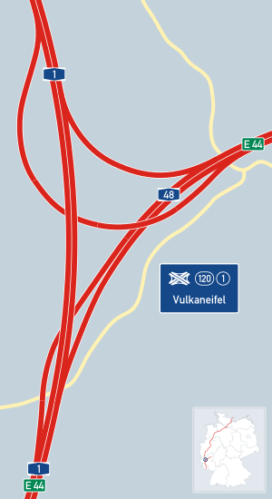
Vulkaneifel motorway triangle
| Vulkaneifel triangle | |
|---|---|
|
|
|
| map | |
| location | |
| Country: | Germany |
| State : | Rhineland-Palatinate |
| Coordinates: | 50 ° 11 '7 " N , 6 ° 53' 57" E |
| Height: | 426 m above sea level NN |
| Basic data | |
| Design type: | Complete triangle |
| Bridges: | 3 (motorway) / 1 (other) |
| Construction year: | 1997 |
The Vulkaneifel triangle is a motorway triangle in Rhineland-Palatinate , which is located near Daun . Here the Autobahn 1 branches off from the Trier - Koblenz route (initially AutobahnNr .: A74 / E74) to the north and begins the Autobahn 48 in the direction of Koblenz .
history
As part of the planning of the Reichsautobahn from the (today's) A3 motorway via Koblenz through the Eifel to Wittlich and Trier, a motorway triangle was planned for a junction to the north as early as the 1930s. From Kaisersesch to the federal highway 49 near Wittlich , the construction was realized as a two-lane federal highway 408 from the 1950s using old earthworks. All bridges were designed to be wide for the later final construction, the gradients still correspond to the original plans. The earthworks already completed on the planned triangle at that time were used unchanged for the construction of the A1 and the expansion of the A48.
geography
The motorway triangle is located in the eponymous Vulkaneifelkreis , east of the city of Daun . The surrounding communities are Mehren and Steiningen , on whose territory it is also located. The closest larger cities are Trier (in the southwest) and Koblenz (in the northeast).
particularities
The A1 is interrupted in the further course in the direction of Cologne between the Kelberg and Blankenheim (Ahr) exits , a gap is currently being planned. The triangle is located in the middle of the Vulkaneifel Nature Park , not far from the Schalkenmehrener Maar .
Traffic volume
| From | To | Average daily traffic volume |
Share of heavy goods traffic |
||||
|---|---|---|---|---|---|---|---|
| 2005 | 2010 | 2015 | 2005 | 2010 | 2015 | ||
| AS Daun (A1) | AD Vulkaneifel | 8,100 | 11,600 | 11,100 | 9.7% | 9.0% | 8.8% |
| AD Vulkaneifel | AS Mehren (A 1) | 20,900 | 23,200 | 25,700 | 16.3% | 13.3% | 13.0% |
| AD Vulkaneifel | AS Ulmen (A 48) | 23,800 | 22,400 | 23,700 | 14.1% | 14.3% | 14.6% |
Individual evidence
- ↑ Conti STRASSENATLAS DEUTSCHLAND, Lingen Verlag Cologne, approx. 1964
- ↑ Pocket Atlas WEST GERMANY; Kümmerly & Frey, Bern, approx. 1960
- ↑ Manual road traffic census 2005. (PDF) Results on federal motorways. BASt Statistics, 2005, accessed on May 4, 2020 .
- ↑ Manual road traffic census 2010. (PDF) Results on federal motorways. BASt Statistics, 2010, accessed on May 4, 2020 .
- ↑ Manual road traffic census 2015. (PDF) Results on federal motorways. BASt Statistics, 2015, accessed on August 25, 2017 .
