Autobahn triangle Hamburg-Südost
| Autobahn triangle Hamburg-Südost | |
|---|---|
|
|
|
| map | |
| location | |
| Country: | Germany |
| State : | Hamburg |
| Coordinates: | 53 ° 30 '26 " N , 10 ° 4' 47" E |
| Height: | 3 m above sea level NN |
| Basic data | |
| Design type: | left-hand trumpet |
| Bridges: | 3 (motorway) / 5 (other) |
| Construction year: | 1985 |
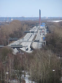
| View from the Georgswerder energy hill to the A1 between the Norderelbe triangle and the Hamburg-Südost triangle |
|
The Hamburg-Südost autobahn triangle (abbreviation: AD Hamburg-Südost ; short form: Hamburg-Südost triangle ) is a freeway triangle in Hamburg . It connects the federal highway 1 ( Hansalinie ; E 22 ) with the federal highway 25 ( Marschenautobahn ).
geography
The motorway triangle is located in the city of Hamburg , more precisely in the Moorfleet district in the Bergedorf district . Surrounding districts are Allermöhe , Billbrook , Billwerder , Rothenburgsort and Tatenberg . It is located about 7 km southeast of Hamburg city center and about 20 km northwest of Geesthacht . The Norderelbe runs around one kilometer to the west and is crossed by the A1 in the direction of Bremen on the Moorfleet motorway bridge .
The Hamburg-Südost motorway triangle has junction number 35 on the A 1 and number 1 on the A 25.
history
The original plan was to extend the A 25 beyond the triangle with a route over the Horner roundabout on the A 24 , City Nord and Fuhlsbüttel airport to the A 7 at Norderstedt . The plans for this so-called "Osttangente" have largely been abandoned, but there are still some preliminary construction work such as the bridge of the Jahnring and the Hebebrandstrasse over the route that has still been kept free.
Design and state of development
The A1 has six lanes, the A 25 four lanes. The relation from the A 1 from north to the A 25 is single-lane, the remaining connecting ramps are two-lane.
The triangle is laid out as a left-handed trumpet . The main bridge structure leads the A 25 over the A 1. In addition, the triangle on the A 1, together with the Hamburg-Moorfleet junction, forms a so-called double junction, so its connecting ramps are also integrated into the junction.
Traffic volume
The triangle is traveled by an average of around 110,000 vehicles every day.
| From | To | Average daily traffic volume |
Share of heavy goods traffic |
||||
|---|---|---|---|---|---|---|---|
| 2005 | 2010 | 2015 | 2005 | 2010 | 2015 | ||
| AS Hamburg-Moorfleet (A 1) | AD Hamburg-Southeast | 90,200 | 96,100 | 91,200 | 20.1% | 17.7% | 16.5% |
| AD Hamburg-Southeast | AD Norderelbe (A 1) | 102,500 | 106,300 | no data | 19.4% | 13.5% | no data |
| AD Hamburg-Southeast | AS Hamburg-Allermöhe (A 25) | 40,600 | 37,600 | 41,600 | 10.1% | 8.6% | 6.7% |
Junction points and driving relationships
|
↓↓↓ ↑↑↑ |

|
↓↓↓ ↑↑↑ |
|
↓↓ ↑↑ |
Individual evidence
- ^ Hendrik Bugdoll: Triangle Hamburg-Southeast. (No longer available online.) In: Autobahnkreuze & Autobahnreiecke in Germany. 2018, archived from the original on December 25, 2017 ; accessed on March 24, 2018 . Info: The archive link was inserted automatically and has not yet been checked. Please check the original and archive link according to the instructions and then remove this notice.
- ↑ Manual road traffic census 2005. (PDF) Results on federal motorways. BASt Statistics, 2005, accessed on March 18, 2018 .
- ↑ Manual road traffic census 2010. (PDF) Results on federal motorways. BASt Statistics, 2010, accessed on March 18, 2018 .
- ↑ Manual road traffic census 2015. (PDF) Results on federal motorways. BASt Statistics, 2015, accessed on March 18, 2018 .

