
Hamburg-Moorfleet
|
district of Hamburg |
|
|---|---|
  |
|
| Coordinates | 53 ° 30 '15 " N , 10 ° 5' 7" E |
| surface | 4.3 km² |
| Residents | 1228 (Dec. 31, 2019) |
| Population density | 286 inhabitants / km² |
| Post Code | 2 .... |
| prefix | 040 |
| district | Bergedorf |
| Transport links | |
| Highway |
|
| bus | 124, 120, 220, 222, 230 |
| Source: Statistical Office for Hamburg and Schleswig-Holstein | |
Moorfleet is a Hamburg district in the Bergedorf district .
geography

Moorfleet is part of the marshland and lies directly on the Dove Elbe , a tributary of the Elbe . The district is located in the wet marshland and is sparsely populated. Moorfleet forms the transition from the rural Vier- und Marschlande to the industrial and commercial areas of the eastern foothills of the Port of Hamburg . In this respect, the image of the district is shaped on the one hand by horticulture and agriculture, on the other hand by industrial areas and the highways 1 and 25 , which cut the district up.
history

According to a bishopric from 1162, the area was initially called Thom Urenfleth . The name was derived from a branch of the Elbe that no longer exists today. Ur has the meaning of "moisture", Fleet refers to this very watercourse. In 1623 the area was named Morenvliet on a survey drawing . Until the 20th century the name of the place was Moorfleth , before its current spelling was established.
Moorfleet is part of the wet marshland area, but - contrary to what its name suggests - it is not located in a moorland area.

The area has been settled since around the end of the 12th century and has long belonged to the old Billwärder , today's Billwerder . In 1331 Moorfleet was named as a church location in the bell document when church bells were sold to the miner Johann Grube, who was supposed to repair the dykes damaged by storm surge. In 1395, the city of Hamburg bought several villages from Count Otto I. von Schauenburg for 2500 Marks to secure trade through Elbe shipping, including the Moorfleets area. It came to the Landherrschaft Bill- and Ochsenwerder . The farmers in the area first grew hops and barley for the Hamburg beer breweries. Only after the Thirty Years' War from 1618 to 1648, from which the moor floaters suffered considerably, did they switch from growing grain to growing vegetables and gradually recovered economically. Between 1741 and 1771 there were several severe floods in Moorfleet due to storm surges .


During the so-called French era in 1813, the occupied moorland was plundered and most of it burned down to create a free field of fire. In 1830 the rulership of the marshland was established , into which Moorfleet passed. From the middle of the 19th century a huge industrial area began to develop in the northeastern Moorfleet, which became Hamburg's own district of Billbrook from 1913 . The north-western part, on the other hand, developed into a densely populated area at the same time. The separation from Moorfleet took place in 1894, the then densely populated area now forms the current district of Rothenburgsort .
In October 1944, Moorfleet was also bombed by Allied airmen. Many houses were destroyed. The construction of the Bille estate began in 1948. In 1962, Moorfleet was not spared the flood disaster , and there were fatalities. From 1975 to 1981 the Autobahn 25 and the Hamburg-Südost triangle were built .
The Bille-Siedlung
The Bille-Siedlung marks an equally well-known and sad chapter of the district. The approximately 31 hectare area was initially a large rinsing field made of Elbe and harbor sediments, which was created in 1935 after the confluence of the Dove Elbe was artificially moved one kilometer to the south. To improve the quality of the soil, a one and a half meter thick layer of harbor silt was applied, which, however, developed into one of the largest and most publicly effective environmental scandals in Hamburg between 1989 and 1991. The harbor silt contained considerable amounts of arsenic , cadmium and dioxins , which got into the topsoil of the properties and acutely endangered the health of the residents. Most of the approximately 800 residents accepted the town's offers to buy and left the area. A renovation followed, only a few houses could remain standing. Today, among other things, there is a golf course on the renovated area.
statistics
- Minor quota: 16.7% [Hamburg average: 16.3% (2017)].
- Elderly rate: 15.6% [Hamburg average: 18.2% (2017)].
- Proportion of foreigners: 15.9% [Hamburg average: 17.1% (2017)].
- Unemployment rate: 5.1% [Hamburg average: 5.2% (2017)].
The average income per taxpayer in Moorfleet is EUR 34,387 annually (2013), the Hamburg average is EUR 39,054.
Culture and sights
The number and year of construction of the church buildings are not known. The carver Hein Baxmann created an altar for the Moorfleeter Church in 1618 and added a renaissance pulpit as well as pastors' and Juraten stalls to it from 1621 to 1625. The church, badly damaged after a severe storm, was demolished. Only the old pulpit and the old Juraten stalls remained undamaged. Today's St. Nikolaikirche was built in the same place of the old church in 1681. The neo-Gothic brick tower dates from 1885.
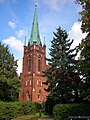
St. Nicholas Church

St. Nikolai

Half-timbered house Vogeler (1838)

Moorfleeter dike 100

"Art excavator" in the Holzhafen

Julius-Grube- Werft at the Holzhafen

Bettors in the sand wiping


politics
For the election to Hamburg citizenship , Moorfleet belongs to the constituency of Bergedorf . The 2015 state election led to the following result:
- SPD 47.8% (-0.6)
- CDU 19.5% (-7.5)
- AfD 11.4% (+11.4)
- FDP 6.6% (+0.8)
- Left 5.9% (+0.2)
- Green 5.2% (-0.8)
- Other 3.6% (–3.5)
Economy and Infrastructure
The goods traffic center (GVZ), located directly at the A1 / A25 motorway triangle, was built in 2001. The branches of Ikea and Bauhaus Moorfleet, which can be seen from afar , directly on the A1, were built in 2002. Moorfleet is the location of the Moorfleet sail maker and the well-known Hamburg Jazz Archive.
Personalities
- Heinrich Matthias Sengelmann (1821–1899), founder of the Alsterdorfer Anstalten , was pastor in Moorfleet from 1846–1853
- Johann Hinrich Lütkens (1746–1814), pastor of Moorfleet and hymn poet
See also
literature
- Harald Richert: 1395–1995: The Marshlands 600 years near Hamburg. In Lichtwark booklet . No. 59, December 1994. Ed. Lichtwark Committee, Bergedorf. (See now: Verlag HB-Werbung, Hamburg-Bergedorf. ISSN 1862-3549 ).
- Horst Schulz: The parish of Moorfleet. In Lichtwark . No. 34, December 1971. Ed. Lichtwark Committee, Bergedorf. (See now: Verlag HB-Werbung, Hamburg-Bergedorf. ISSN 1862-3549 ).
- Daniel Tilgner (Ed.): Hamburg from Altona to Zollenspieker. The Haspa manual for all districts of the Hanseatic city. Hoffmann and Campe, Hamburg 2002, ISBN 3-455-11333-8 .
- Franklin Kopitzsch , Daniel Tilgner (Ed.): Hamburg Lexikon. 2nd, revised edition. Zeiseverlag, Hamburg 2000, ISBN 3-9805687-9-2 .
Web links
Individual evidence
- ^ Horst Beckershaus: The names of the Hamburg districts. Where do they come from and what they mean , Hamburg 2002, ISBN 3-434-52545-9 , p. 80
- ↑ Quota of minors in the Hamburg districts in 2017
- ↑ Proportion of 65-year-olds and older in the Hamburg districts in 2017
- ↑ Proportion of foreigners in the Hamburg districts in 2017
- ↑ Unemployment rate in the Hamburg districts in 2017
- ↑ Statistical Office for Hamburg and Schleswig-Holstein (ed.): Hamburg District Profile 2016 (= NORD.regional . Volume 19 ). 2018, ISSN 1863-9518 ( Online PDF 6.6 MB [accessed February 12, 2018]).
- ↑ wahlen-hamburg.de
Allermöhe | Altengamme | Bergedorf | Billwerder | Curslack | Kirchwerder | Lohbrugge | Moorfleet | Neuallermöhe | Neuengamme | Ochsenwerder | Reitbrook | Spadenland | Tatenberg