Hamburg-Neuengamme
|
Neuengamme district of Hamburg |
|
|---|---|
| Coordinates | 53 ° 26 '47 " N , 10 ° 13' 19" E |
| surface | 18.6 km² |
| Residents | 3730 (Dec. 31, 2019) |
| Population density | 201 inhabitants / km² |
| Post Code | 21037, 21039 |
| prefix | 040 |
| district | Bergedorf |
| Source: Statistical Office for Hamburg and Schleswig-Holstein | |
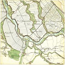
Neuengamme ( Low German : Neengaam / Neegamm ) is a Hamburg district in the Elbmarsch area of the Vierlande in the Bergedorf district . Neuengamme was originally an Elbe island between the rivers of the main river Elbe, the Gose Elbe and the Dove Elbe . The area was settled in the form of a street village along the river dike on the Dove Elbe, on the top of which the main road through the village is located. Road connections to the neighboring districts of Altengamme , Kirchwerder and Curslack exist on other old, partly connected dyke structures and over bridges .
history
The name Neuengamme, originally Nova Gamma or Nyengam , is of Indo-European origin and means "New Earth". The history of the place, like that of all four places in the Vierlande, is very closely linked to the history of the area.
Foundation in the Middle Ages
From around 1100 the later Vierlande, some fertile Elbe islands between river arms of the Elbe, which was divided here in many ways, were diked. From the beginning, four church squares were divided up: Curslack , Altengamme , Neuengamme (Latin in 1188: insula nondum cultä - “island not yet built on”) and Kirchwerder . These plans were implemented at different speeds; Neuengamme was first mentioned in a document in 1212; at that time still called New Island (Latin: nova insula ). In 1261 the town of Neuengamme already existed, and in 1316 the village was so large that the first pastor moved into St. Johannis. Today's nave (without tower) is probably the church building at that time.
Dyke construction
Since the diked areas could only be kept dry with difficulty - hardly at all in autumn and winter - the connection between the villages was not always guaranteed. This often became a problem when the population increased and common dike defense became more important. For this purpose, additional dams were built, which were not used for defense against floods, but for road construction: a connecting dike to Altengamme was raised in 1482, and such a connecting dike to Kirchwerder was built in 1492. Curslack, which is on the other side of the Dove Elbe directly across from Neuengammes, could not be connected in this way; Contact with ferries was maintained until the first bridge was built.
Bridges, flowers and vegetables
The rich, fertile areas of the Vierlande, as the four parishes are now called, had to fight against a main enemy: the wet subsoil. The pumping stations could not transport all the water that collected in the deepest places back into the Elbe. Only when the first windmills reached Vierlande from 1595 onwards could the country reap permanent harvests; the nearby, up-and-coming Hamburg was the best buyer for the Vierländer products.
The rich areas without military protection attracted interested parties. In 1620 the Lüneburgers crossed the Elbe and incorporated the Vierlande, including Neuengamme, into their territory. It was not until 1867 that the Vierlande were placed under Hamburg administration.
The construction of the first permanent bridge to Curslack, the Blue Bridge , made Neuengamme and Curslack a double town , which is only separated by the narrow Dove Elbe. Further bridges (1873 in Neuengamme-Niederwärts and the church bridge in 1899) further strengthened this connection; today it is difficult to tell the places apart while crossing.
When the Dutch fashion of growing and displaying expensive flowers was adopted in the Hamburg area , the enterprising Fourlanders noticed that more money can be made with flowers than with cauliflower. As a result, in addition to growing vegetables from 1675, there was also intensive floriculture, which continues to this day. Only when tomato cultivation was introduced in the Vierlanden around 1880 did the original vegetable cultivation come back to life.
After natural gas was discovered on the northern outskirts shortly after 1900, the town began to undergo little industrialization. On November 4, 1910, the first flame from Neuengammer natural gas ignited. This is still supported today; the associated company is not based in Neuengamme, but in neighboring Bergedorf .
concentration camp
Over 100,000 people from all over Europe were held in the Neuengamme concentration camp (from December 1938 to April 1940, a subcamp of the Sachsenhausen concentration camp , then an independent main camp with more than 85 subcamps in the end ) under inhumane conditions. In 1940 and 1942, the concentration camp prisoners had to dig a canal to the Dove Elbe and make it navigable in order to be able to transport bricks from the main camp of Neuengamme to Hamburg. Around 1,600 prisoners were forced to move 213,000 cubic meters of earth with their hands and wheelbarrows. The bricks manufactured in the main camp were to be used in the course of the redesign of Hamburg to become one of the leaders' cities with several representative party buildings, a 250 meter high Gauhochhaus and an Elbe bridge near today's Elbe Tunnel. Of the people imprisoned in Neuengamme and its satellite camps until 1945, at least 42,900 lost their lives as a result of the inhumane working and living conditions, through direct murders and as victims of the camp evictions: at the end of the war, the SS tried to cover up the traces of the concentration camp, thousands prisoners found in death marches and in the bombing of the bay of Lübeck ships at Cap Arcona and Thielbek by British Hawker Typhoon - fighter-bomber to death.
After the end of the war, a British internment camp for Nazi officials and from 1948 a prison was set up on the former site of the concentration camp , which was expanded in 1970 to include a youth detention center. Today the memorial is located on the site of the former concentration camp .
statistics
- Minor quota: 17.5% [Hamburg average: 16.3% (2017)].
- Elderly rate: 20.7% [Hamburg average: 18.2% (2017)].
- Proportion of foreigners: 4.9% [Hamburg average: 17.1% (2017)].
- Unemployment rate: 2.4% [Hamburg average: 5.2% (2017)].
The average income per taxpayer in Neuengamme is 40,936 euros annually (2013), the Hamburg average is 39,054 euros.
politics
For the election to Hamburg citizenship , Neuengamme belongs to the constituency of Bergedorf . The 2015 state election brought the following results:
- SPD 45.9% (+2.1)
- CDU 22.5% (-11.3)
- Green 9.0% (+0.8)
- FDP 8.2% (+1.9)
- AfD 7.3% (+ 7.3)
- Left 3.9% (+0.6)
- Other 3.2% (-1.4)
Culture and sights
Buildings
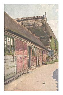
The old, well-preserved half-timbered houses and the
St. John's Church
The Neuengamme parish was mentioned in a document as early as 1261. The church building is a medieval brick building that was partly clad with field stones. More detailed information has not been passed down. In 1634 an organ by Gottfried Fritzsche was installed, the majority of which is still preserved despite renovations in 1803 and 1861. Between 1801 and 1803 a wooden vault was built into the church.
The bell tower, a wooden structure that was erected in 1630 and given its current form in 1750, is offset a few meters from the nave and has no structural contact with it. This is a common design for the Vierlande. There are three bells hanging in the tower, the largest of which was cast by Geert van Wou in 1487 .
Also typical of the area of the small half-timbered cultivation on the front side, the so-called "is BrautHAUS " of 1619. By this side entrance the bride enters the church at weddings and so can the entire aisle stride. The main entrance to the church, the "Paradise", is on the long side, directly in front of the chancel.
The interior of the church was carefully redesigned between 1956 and 1961. Cheeks from the 17th to 19th centuries, hat stands and altarpiece have been preserved. The oldest surviving four-country tombstone from 1470 can also be found here.
Public facilities
The parish of St. Johannis zu Neuengamme has a parish hall with a youth cellar, in which disco events are regularly held by volunteers . There are also various leisure activities with full-time employees and volunteers, confirmands, members of various groups who meet in the community hall (e.g. the theater group), and a football tournament is organized every year.
See also
Individual evidence
- ↑ Note: In the map by Gustav Adolf von Varendorff from 1796 shown here, the course of the (present-day) Gose Elbe running northwest from the Kiebitzbrack is also shown with this name, parallel to the Dowe Elbe .
- ^ Horst Beckershaus: The names of the Hamburg districts. Where do they come from and what they mean. Hamburg 2002, ISBN 3-434-52545-9 , p. 81.
- ↑ Quota of minors in the Hamburg districts in 2017
- ↑ Proportion of 65-year-olds and older in the Hamburg districts in 2017
- ↑ Proportion of foreigners in the Hamburg districts in 2017
- ↑ Unemployment rate in the Hamburg districts in 2017
- ↑ Statistical Office for Hamburg and Schleswig-Holstein (ed.): Hamburg District Profile 2016 (= NORD.regional . Volume 19 ). 2018, ISSN 1863-9518 ( Online PDF 6.6 MB [accessed February 12, 2018]).
- ↑ http://www.wahlen-hamburg.de/wahlen.php?site=left/gebiete&wahltyp=3#index.php?site=right/result&wahl=973&gebiet=63&typ=4&stimme=1&gID=2&gTyp=2
literature
- Joachim Gerhardt: The old organs in the churches of the Vier- und Marschlande . In: Lichtwark No. 12. Ed. Lichtwark Committee, Bergedorf, 1955. See now: Verlag HB-Werbung, Hamburg-Bergedorf. ISSN 1862-3549 .
- H. Schween: From Neuengamme's landscape, dams and dikes and his last governors . In: Lichtwark. No. 24. Ed. Lichtwark Committee, 1962. See now: Verlag HB-Werbung, Hamburg-Bergedorf. ISSN 1862-3549 .
- H. Schween: Neuengammes Becoming. In: Lichtwark No. 22. Ed. Lichtwark Committee, 1962. See now: Verlag HB-Werbung, Hamburg-Bergedorf. ISSN no. 1862-3549.


