
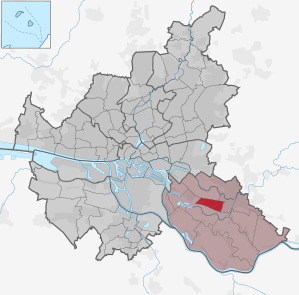
Hamburg-Neuallermöhe
|
district of Hamburg |
|
|---|---|
  |
|
| Coordinates | 53 ° 29 ′ 0 ″ N , 10 ° 10 ′ 0 ″ E |
| height | 2 m above sea level NN |
| surface | 4.2 km² |
| Residents | 23,479 (Dec. 31, 2019) |
| Population density | 5590 inhabitants / km² |
| Post Code | 21035 |
| prefix | 040 |
| district | Bergedorf |
| Transport links | |
| Highway |
|
| S-Bahn Hamburg |
|
| bus | 12, 234, 329, 335, 529, 629 |
| Source: Statistical Office for Hamburg and Schleswig-Holstein | |
Neuallermöhe is a Hamburg district in the Bergedorf district , which was newly formed on January 1, 2011. As a result, the settlements Neuallermöhe-West, previously part of Allermöhe , and Neuallermöhe-Ost, previously part of Bergedorf , were administratively united.
geography
Neuallermöhe is bounded in the north by the Berlin-Hamburg railway and in the south by the A 25 motorway . The main Allermöhe drainage ditch closes off the district to the west, and the Nettelnburger Landweg to the east. Historically, Neuallermöhe belongs to the Vier- und Marschlanden , despite its predominantly urban structure today.
history
Neuallermöhe-Ost was built between 1982 and 1994, Neuallermöhe-West since the 1990s. Neuallermöhe was Hamburg's youngest district until construction work began on HafenCity . On January 2, 2011, the district development was celebrated.
In the 1920s , the then senior construction director Fritz Schumacher envisaged a large settlement called Billwerder-Allermöhe on the railway line to Bergedorf and Berlin for the first time as part of his concept of “organic” development axes along the Hamburg long-distance traffic routes . In 1973, the planning was made more concrete: The Hamburg Senate passed a change to the land use plan , which created the legal basis for a new settlement with around 70,000 inhabitants including commercial and leisure areas on 1,325 hectares.

In 1979 planning work began for the 123 hectare Neu-Allermöhe Ost district . With catchy slogans such as “living by the water” and “ ecological building ” and a low planned housing density, the aim was to achieve a special quality of living for young families of the ecologically oriented middle class, because the metropolis of Hamburg saw itself as a loser in the face of increasing urban exodus. In the years from 1982 to 1994 approx. 3800 residential units were built on an area of 123 hectares. The Hamburg environmental authority and the Federal Ministry of Construction promoted the operation of a plant-owned sewage treatment plant .
At the end of the 1980s there was a shortage of inexpensive living space in Hamburg, also in view of the reunification of Germany and a booming immigration from many countries. In order to defuse the situation, the Senate decided in October 1989 to restart the further development of Neu-Allermöhe. The 340 hectare area to be developed for the Neu-Allermöhe West project was already owned by the city; the area was raised two meters with sand.
In order to avoid further urban sprawl and without going back to the concrete settlement of the 1970s, careful attempts were made to compact the building fabric. The development in the new residential area has a maximum of four storeys and looks almost urban around the new S-Bahn station . Neu-Allermöhe West was advertised as “Hamburg's youngest district” and at the time was the largest residential project in Hamburg and one of the largest in Germany.
statistics
- Minor quota: 23.1% [Hamburg average: 16.3% (2017)].
- Elderly rate: 8.7% [Hamburg average: 18.2% (2017)].
- Proportion of foreigners: 17.0% [Hamburg average: 17.1% (2017)].
- Unemployment rate: 5.9% [Hamburg average: 5.2% (2017)].
The average income per taxpayer in Neuallermöhe in 2013 was EUR 28,633 annually, the Hamburg average was EUR 39,054.
politics
For the election to Hamburg citizenship , Allermöhe belongs to the constituency of Bergedorf . The 2020 citizenship election led to the following result:
Culture and sights

Buildings
- Catholic Edith Stein Church with parish center, built in 1991/92
- In the eastern part of Neu-Allermöhe is the Evangelical Lutheran " Franz-von-Assisi Church ". It was inaugurated in 1993 and is Hamburg's youngest church building .
- The 25-meter-high “Zuckerstangen” observation tower , a sculpture with an 18-meter-high viewing platform, has stood on the Fleetplatz since 2004 .
sport and freetime
The Allermöher See (bathing lake) lies between Neu-Allermöhe West and East and there is another bathing lake to the west of Neu-Allermöhe West, which is surrounded by parkland. There are sports facilities in Neu-Allermöhe Ost and since 1997 in Neu-Allermöhe West. You can go canoeing and kayaking in the canals.
Allermöhe is home to the sports club Nettelnburg / Allermöhe , which has one of the largest youth football departments in Northern Germany.
Drainage system - the "Fleete"


Instead of the drainage ditches typical of the march, a system of larger drainage canals was created in the backfilled area of Neu-Allermöhe. They are - in line with the flow waters in the estuary of the rivers Alster and Bille in Hamburg's old town - in official parlance as canals called. However, since it is standing water, this designation does not apply. The Allermöher “Fleete” emerged long after the area was dyed .
The Allermöher fleet system begins at a "flushing inlet" on the Dove Elbe and includes the residential areas of Neu-Allermöhe before it meets the Dove Elbe again at the Allermöhe pumping station . Its catchment area is limited to the north by the railway embankment , to the east by the Schleusengraben , to the south by the A 25 motorway and to the west by the pumping station ditch. It is fed by precipitation and by the Dove Elbe. The total amount of water in the canal system is approx. 177,500 m³.
Neu-Allermöhe West is structurally divided by four side canals ( duck, lapwing, heron and swan cane ) running in north-south direction and on average two meters wide ; two eight meter wide main canals ( Fährbuernfleet and Allermöher Bahnfleet ) connect to the open drainage system that serves Neu-Allermöhe Ost and parts of Nettelnburg.
There are also the Mövenfleet, Allermöher Randfleet, Allermöher Hauptfleet, Annenfleet and the Landscheidefleet . The area of the canal was declared a park in 1990. Public institutions such as schools and day-care centers were built on its banks; But four-storey residential buildings were also permitted in order to allow “as many residents as possible to enjoy a preferred residential area” (justification for the development plan).
Flushing the canal
The fleet system is generally closed. The canals are “flushed” with water from the Dove Elbe five days a week using a system of 16 dam structures controlled by a computer system . In this way, the water in each section of the canal is changed once a week.
The water is taken from the Dove Elbe at a "flushing inlet" and fed back into the pumping station , where rubbish and natural debris are filtered out. The current enriches the water with oxygen that is essential for plants and animals and prevents eutrophication caused by organic decomposition processes and the discharge of road sewage . In addition, the flow prevents the iron found in the groundwater from collecting in the canal system. Through the introduction of oxygen, the bivalent, dissolved iron is oxidized to trivalent iron, which precipitates in the form of hydroxidic and oxidic compounds. These iron precipitates are carried away by the flow. Periodic ocher deposits caused by iron bacteria, which show up as a strong yellow coloration of the water in spring and autumn at water temperatures of approx. 8 ° C, are removed by regular flushing.
The flushing of the canal is regulated by 16 dam structures and the necessary flushing water (a flow rate of approx. 3 m³ / s) is taken from the Dove Elbe. At the rinse inlet the water falls from approx. 0.95 m above sea level. NHN (the mean water level of the Dove Elbe) through a mechanical rake to hold back larger floating matter, then it flows into the canal system. The flushed water, rainwater, an average flow rate of 9 million m³ / a at the pumping station flows back into the Dove Elbe.
Since the canals do not have clearly defined flow paths, all flow movements through the dam structures can be defined. This is not only useful for flushing, but also to increase the rainwater storage capacity of the fleet system; In the event of heavy rain, the canal system can take on the role of a retention basin. Stowage structures 1–14, when folded up, have a height of 0.4 m below sea level . The immobile 15 and 16 are only 0.75 m below sea level. This enables excess water to flow out of the fleet system at any time. The flushing is carried out by a computer system that controls when the dam structures 1–14 are folded up and down.
The rinsing takes place Monday to Friday, with a different rinsing route for each day; this ensures that each fleet is cleaned weekly. On a normal weekday, all dams fold up at 7:00 a.m. In the meantime, the flushing inlet is opened, whereby the water flows into the canal system up to the dam structures 3, 4, 5, 6 and 7. It stays there until 9:30 a.m. to give the water time to build up and to generate the necessary speed - approx. 0.83–1.38 m / s - for flushing. During this time, the water in the dammed area rises to a maximum of 0.4 m below sea level . At 9:30 a.m., some dam structures are lowered (the exact flushing route is, as already mentioned, different on every weekday) and the water takes its course through the canal system. On the rinsing route, the water level rarely rises above 0.5 m below sea level . At 1 p.m., all the dam structures finally open and the water begins to flow from the Allermöhe pumping station back into the Dove Elbe.
In the event of heavy precipitation, the water level can rise above 0.3 m below sea level and the water can flow over the 10 cm lower dam structures. Excess water then runs off through the Allermöhe pumping station to the Dove Elbe, so the water exchange takes place automatically. Because of the reduced oxygen consumption of aquatic plants and animals in winter, and since flushing is relatively expensive, it can take place between the beginning of December and the end of December February even dropped entirely.
Mowing the banks of the canals
By agreement with the horticultural authority at that time, the water management authority is still responsible for maintaining the canals in the water itself and at the edge up to 2 m from the normal water level ( 0.7 m below sea level ). Since 2001, the vegetation in this area has not been mowed.
Outside the immediate vicinity of the water, Revier 3 of the Bergedorf gardening and civil engineering department is responsible for maintenance. The grassy areas on the embankment are mowed twice a year (early June and mid to late August) with a flail mower; Mown grass stays in place. To keep sidewalks clear, their verge is mowed up to six times from April to October .
Economy and Infrastructure
economy
The retail trade is represented in the district in three local supply centers : Fleetplatz, Edith-Stein-Platz and Grachtenplatz.
traffic
On the southern border of Neuallermöhe, the so-called Marschen-Autobahn, the Bundesautobahn 25, runs along. With the Hamburg-Neuallermöhe-West and Hamburg-Nettelnburg junctions on the A 25, Neuallermöhe has a connection to the trunk road network.
Allermöhe had been on the Hamburg-Bergedorfer Railway since 1842 , which was extended to Berlin in 1846 . The route forms the northern border to the districts of Billwerder and Bergedorf. The Hamburg S-Bahn runs on the tracks on the north side of this line . The Allermöhe (existing since May 30, 1999) and Nettelnburg stops of the Hamburg S-Bahn are served by lines S2 and S21, which connect the district every 10 minutes during the day with Hamburg Central Station and the Bergedorf station.
The VHH takes care of the bus traffic within the Hamburger Verkehrsverbund (HVV) with bus routes that are mainly directed to the Bergedorf train station. This also includes night bus routes 329 and 629 from Bergedorf station and route 529, which is geared towards school traffic.
Within the new development areas, it is largely possible to move almost completely without contact with roads, only on footpaths and cycle paths. The basic structure of the Neu-Allermöhe-Ost district consists of two ring roads, the Henriette-Hertz-Ring and the Fanny-Lewald-Ring, from which all other access roads branch off. The Neu-Allermöhe West residential area is only connected to the rest of the road network at two points: at the Neu-Allermöhe-West motorway junction (exit 3) in the south and on the road via the Neu-Allermöhe Ost residential area to Nettelnburg in the northeast.
education and Science
Primary schools:
- Anton-Ree-Schule Allermöhe (ARSA), named after the reform pedagogue Anton Rée
- Adolph Diesterweg School, named after the pedagogue Adolph Diesterweg
- Clara Grunwald School (CGS), named after the educator Clara Grunwald
Further training:
- Gretel Bergmann School ( district school ), named after the athlete Gretel Bergmann
- Allermöhe high school
See also
Web links
Individual evidence
- ↑ http://www.hamburg.de/innenbehoerde/nofl/2603780/2010-11-02-bis-pm-hamm-neuallermoehe.html
- ↑ http://www.hamburg.de/bezirke/bergedorf/2702134/stadtteil-neuallermoehe.html
- ↑ Quota of minors in the Hamburg districts in 2017
- ↑ Proportion of 65-year-olds and older in the Hamburg districts in 2017
- ↑ Proportion of foreigners in the Hamburg districts in 2017
- ↑ Unemployment rate in the Hamburg districts in 2017
- ↑ Statistical Office for Hamburg and Schleswig-Holstein (ed.): Hamburg District Profile 2016 (= NORD.regional . Volume 19 ). 2018, ISSN 1863-9518 ( Online PDF 6.6 MB [accessed February 12, 2018]).
- ↑ Election results at www.wahlen-hamburg.de, accessed on March 31, 2020.
- ^ The tower of Neu-Allermöhe Hamburger Abendblatt dated August 23, 2004, accessed on March 1, 2017
- ↑ Otto Steigleder: Sportplatz 2000 - a modern sports center in Neuallermöhe-West . In Lichtwark booklet no. 63. Ed. Lichtwark Committee, 1998. See now: Verlag HB-Werbung, Hamburg-Bergedorf, ISSN 1862-3549 .
Allermöhe | Altengamme | Bergedorf | Billwerder | Curslack | Kirchwerder | Lohbrugge | Moorfleet | Neuallermöhe | Neuengamme | Ochsenwerder | Reitbrook | Spadenland | Tatenberg