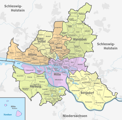
| district
|
Districts
|
district
|
Area
(km²)
|
Residents
|
Population density
(inhabitants / km²)
|
Coordinates
|
map
|
|
Hamburg old town!Hamburg old town
|
101!101-102
|
Hamburg-center
|
02.4!2.4
|
2350
|
979
|
53 ° 33 ′ 0 ″ N, 10 ° 0 ′ 0 ″ E
|

|
|
HafenCity!HafenCity
|
103!103-104
|
Hamburg-center
|
02.2!2.2
|
4925
|
2239
|
53 ° 32 ′ 28 "N, 10 ° 0 ′ 1" E
|

|
|
Neustadt!Neustadt
|
105!105-108
|
Hamburg-center
|
02.3!2.3
|
12,762
|
5549
|
53 ° 33 ′ 7 ″ N, 9 ° 59 ′ 8 ″ E
|

|
|
St. Pauli!St. Pauli
|
109!109-112
|
Hamburg-center
|
02.5!2.5
|
22.097
|
8839
|
53 ° 33 '25 "N, 9 ° 57' 50" E
|

|
|
St George!St. George
|
113!113-114
|
Hamburg-center
|
02.4!2.4
|
11,358
|
4733
|
53 ° 33 ′ 18 "N, 10 ° 0 ′ 44" E
|

|
|
Hammerbrook!Hammerbrook
|
115!115-118
|
Hamburg-center
|
03.0!3.0
|
4619
|
1540
|
53 ° 32 '43 "N, 10 ° 1' 50" E
|

|
|
Borgfelde!Borgfelde
|
119!119-120
|
Hamburg-center
|
00.8!0.8
|
8343
|
10429
|
53 ° 33 ′ 17 "N, 10 ° 2 ′ 4" E
|

|
|
Hamm!Hamm
|
121!121-127
|
Hamburg-center
|
04.0!4.0
|
38,330
|
9583
|
53 ° 33 '39 "N, 10 ° 3' 28" E
|

|
|
Horn!horn
|
128!128-129
|
Hamburg-center
|
05.9!5.9
|
38,373
|
6504
|
53 ° 33 '14 "N, 10 ° 5' 24" E
|

|
|
Billstedt!Billstedt
|
130!130
|
Hamburg-center
|
17.0!17.0
|
70,409
|
4142
|
53 ° 32 '26 "N, 10 ° 6' 4" E
|

|
|
Billbrook!Billbrook
|
131!131
|
Hamburg-center
|
06.1!6.1
|
1740
|
285
|
53 ° 31 '40 "N, 10 ° 5' 10" E
|

|
|
Rothenburgsort!Rothenburgsort
|
132!132-133
|
Hamburg-center
|
07.4!7.4
|
9187
|
1241
|
53 ° 32 ′ 6 "N, 10 ° 2 ′ 27" E
|

|
|
Veddel!Veddel
|
134!134
|
Hamburg-center
|
04.4!4.4
|
4475
|
1017
|
53 ° 31 ′ 0 ″ N, 10 ° 2 ′ 0 ″ E
|

|
|
Wilhelmsburg!Wilhelmsburg
|
135!135-137
|
Hamburg-center
|
35.4!35.4
|
53,518
|
1512
|
53 ° 29 ′ 42 "N, 10 ° 0 ′ 40" E
|

|
|
Little Grasbrook!Little Grasbrook
|
138!138
|
Hamburg-center
|
04.5!4.5
|
1108
|
246
|
53 ° 31 ′ 52 "N, 9 ° 59 ′ 37" E
|

|
|
Steinwerder!Steinwerder
|
139!139
|
Hamburg-center
|
07.4!7.4
|
33
|
4th
|
53 ° 32 ′ 4 "N, 9 ° 57 ′ 26" E
|

|
|
Waltershof!Waltershof
|
140!140
|
Hamburg-center
|
09.8!9.8
|
0
|
0
|
53 ° 31 ′ 40 "N, 9 ° 54 ′ 2" E
|

|
|
Finkenwerder!Finkenwerder
|
141!141
|
Hamburg-center
|
19.7!19.7
|
11,754
|
597
|
53 ° 31 '38 "N, 9 ° 51' 58" E
|

|
|
Neuwerk!Neuwerk
|
142!142
|
Hamburg-center
|
07.6!7.6
|
30th
|
4th
|
53 ° 55 ′ 16 ″ N, 8 ° 30 ′ 2 ″ E
|

|
|
Altona old town!Altona old town
|
201!201-206
|
Altona
|
02.8!2.8
|
29,169
|
10418
|
53 ° 32 ′ 56 "N, 9 ° 56 ′ 52" E
|

|
|
Sternschanze!Sternschanze
|
207!207
|
Altona
|
00.5!0.5
|
8092
|
16184
|
53 ° 33 '42 "N, 9 ° 57' 44" E
|

|
|
Altona North!Altona-North
|
208!208-210
|
Altona
|
02.2!2.2
|
24,536
|
11153
|
53 ° 33 ′ 47 "N, 9 ° 56 ′ 43" E
|

|
|
Ottensen!Ottensen
|
211!211-214
|
Altona
|
02.8!2.8
|
35,585
|
12709
|
53 ° 33 '14 "N, 9 ° 55' 4" E
|

|
|
Bahrenfeld!Bahrenfeld
|
215!215-217
|
Altona
|
10.6!10.6
|
30.203
|
2849
|
53 ° 34 '26 "N, 9 ° 53' 33" E
|

|
|
Groß Flottbek!Groß Flottbek
|
218!218
|
Altona
|
02.4!2.4
|
11,111
|
4630
|
53 ° 33 '55 "N, 9 ° 52' 39" E
|

|
|
Othmarschen!Othmarschen
|
219!219
|
Altona
|
06.0!6.0
|
15,737
|
2623
|
53 ° 33 '10 "N, 9 ° 53' 40" E
|

|
|
Lurup!Lurup
|
220!220
|
Altona
|
06.3!6.3
|
36,610
|
5811
|
53 ° 35 '35 "N, 9 ° 52' 58" E
|

|
|
Osdorf!Osdorf
|
221!221
|
Altona
|
07.2!7.2
|
26,565
|
3690
|
53 ° 34 '22 "N, 9 ° 50' 48" E
|

|
|
Nienstedten!Nienstedten
|
222!222
|
Altona
|
04.3!4.3
|
7181
|
1670
|
53 ° 33 '18 "N, 9 ° 50' 41" E
|

|
|
Blankenese!Blankenese
|
223!223-224
|
Altona
|
07.7!7.7
|
13,730
|
1783
|
53 ° 33 ′ 30 "N, 9 ° 48 ′ 40" E
|

|
|
Iserbrook!Iserbrook
|
225!225
|
Altona
|
02.7!2.7
|
11,423
|
4231
|
53 ° 34 ′ 35 ″ N, 9 ° 49 ′ 24 ″ E
|

|
|
Sulldorf!Sülldorf
|
226!226
|
Altona
|
05.7!5.7
|
9436
|
1655
|
53 ° 35 ′ 6 ″ N, 9 ° 47 ′ 39 ″ E
|

|
|
Cracks!Cracks
|
227!227
|
Altona
|
16.7!16.7
|
15,886
|
951
|
53 ° 34 ′ 59 "N, 9 ° 45 ′ 13" E
|

|
|
Eimsbuttel!Eimsbüttel
|
301!301-310
|
Eimsbüttel
|
03.3!3.3
|
58.004
|
17577
|
53 ° 34 ′ 33 ″ N, 9 ° 57 ′ 6 ″ E
|

|
|
Rotherbaum!Rotherbaum
|
311!311-312
|
Eimsbüttel
|
03.0!3.0
|
16,982
|
5661
|
53 ° 34 ′ 5 ″ N, 9 ° 59 ′ 18 ″ E
|

|
|
Harvestehude!Harvestehude
|
313!313-314
|
Eimsbüttel
|
02.1!2.1
|
17,875
|
8512
|
53 ° 34 ′ 40 "N, 9 ° 59 ′ 20" E
|

|
|
Hoheluft-West!Hoheluft-West
|
315!315-316
|
Eimsbüttel
|
00.7!0.7
|
13,435
|
19193
|
53 ° 34 ′ 48 ″ N, 9 ° 58 ′ 2 ″ E
|

|
|
Lokstedt!Lokstedt
|
317!317
|
Eimsbüttel
|
04.9!4.9
|
29,373
|
5994
|
53 ° 36 ′ 11 "N, 9 ° 57 ′ 23" E
|

|
|
Niendorf!Niendorf
|
318!318
|
Eimsbüttel
|
12.4!12.4
|
40,838
|
3293
|
53 ° 37 ′ 4 ″ N, 9 ° 57 ′ 1 ″ E
|

|
|
Schnelsen!Schnelsen
|
319!319
|
Eimsbüttel
|
09.0!9.0
|
29,604
|
3289
|
53 ° 38 ′ 0 ″ N, 9 ° 55 ′ 0 ″ E
|

|
|
Eidelstedt!Eidelstedt
|
320!320
|
Eimsbüttel
|
08.7!8.7
|
34,257
|
3938
|
53 ° 36 ′ 25 "N, 9 ° 54 ′ 22" E
|

|
|
Stellingen!Stellingen
|
321!321
|
Eimsbüttel
|
05.8!5.8
|
26,683
|
4601
|
53 ° 35 ′ 32 "N, 9 ° 55 ′ 43" E
|

|
|
Hoheluft-Ost!Hoheluft-Ost
|
401!401-402
|
Hamburg North
|
00.6!0.6
|
9694
|
16157
|
53 ° 35 ′ 5 "N, 9 ° 58 ′ 34" E
|

|
|
Eppendorf!Eppendorf
|
403!403-405
|
Hamburg North
|
02.7!2.7
|
25,070
|
9285
|
53 ° 35 ′ 44 "N, 9 ° 59 ′ 2" E
|

|
|
Great Borstel!Great Borstel
|
406!406
|
Hamburg North
|
04.0!4.0
|
9284
|
2321
|
53 ° 36 ′ 49 "N, 9 ° 58 ′ 57" E
|

|
|
Alsterdorf!Alsterdorf
|
407!407
|
Hamburg North
|
03.2!3.2
|
15.204
|
4751
|
53 ° 36 ′ 39 "N, 10 ° 0 ′ 47" E
|

|
|
Winterhude!Winterhude
|
408!408-413
|
Hamburg North
|
07.6!7.6
|
55,491
|
7301
|
53 ° 36 ′ 0 ″ N, 10 ° 0 ′ 0 ″ E
|

|
|
Uhlenhorst!Uhlenhorst
|
414!414-415
|
Hamburg North
|
02.2!2.2
|
18,634
|
8470
|
53 ° 34 ′ 21 ″ N, 10 ° 1 ′ 7 ″ E
|

|
|
Hohenfelde!Hohenfelde
|
416!416-417
|
Hamburg North
|
01.1!1.1
|
10,034
|
9122
|
53 ° 33 '42 "N, 10 ° 1' 15" E
|

|
|
Barmbek brew!Barmbek-South
|
418!418-423
|
Hamburg North
|
03.1!3.1
|
35,827
|
11557
|
53 ° 34 '48 "N, 10 ° 2' 26" E
|

|
|
Dulsberg!Dulsberg
|
424!424-425
|
Hamburg North
|
01.2!1.2
|
17,229
|
14358
|
53 ° 34 ′ 0 ″ N, 10 ° 3 ′ 0 ″ E
|

|
|
Barmbek-Nord!Barmbek-North
|
426!426-429
|
Hamburg North
|
03.8!3.8
|
41,875
|
11020
|
53 ° 36 ′ 19 ″ N, 10 ° 2 ′ 24 ″ E
|

|
|
Ohlsdorf!Ohlsdorf
|
430!430
|
Hamburg North
|
07.2!7.2
|
16,666
|
2315
|
53 ° 37 '33 "N, 10 ° 1' 53" E
|

|
|
Fuhlsbuttel!Fuhlsbüttel
|
431!431
|
Hamburg North
|
07.8!7.8
|
13,441
|
1723
|
53 ° 38 ′ 4 "N, 10 ° 0 ′ 58" E
|

|
|
Long horn!Longhorn
|
432!432
|
Hamburg North
|
13.4!13.4
|
46.144
|
3444
|
53 ° 39 ′ 56 ″ N, 10 ° 0 ′ 5 ″ E
|

|
|
Eilbek!Eilbek
|
501!501-504
|
Wandsbek
|
01.8!1.8
|
22,276
|
12376
|
53 ° 34 ′ 4 "N, 10 ° 2 ′ 44" E
|

|
|
Wandsbek!Wandsbek
|
505!505-509
|
Wandsbek
|
06.0!6.0
|
36,443
|
6074
|
53 ° 34 '55 "N, 10 ° 5' 3" E
|

|
|
Marienthal!Marienthal
|
510!510-511
|
Wandsbek
|
03.2!3.2
|
13,521
|
4225
|
53 ° 34 '8 "N, 10 ° 5' 9" E
|

|
|
Jenfeld!Jenfeld
|
512!512
|
Wandsbek
|
05.0!5.0
|
27,125
|
5425
|
53 ° 34 ′ 20 ″ N, 10 ° 8 ′ 10 ″ E
|

|
|
Tonndorf!Tonndorf
|
513!513
|
Wandsbek
|
03.9!3.9
|
15,148
|
3884
|
53 ° 35 ′ 10 ″ N, 10 ° 7 ′ 29 ″ E
|

|
|
Farmsen-Berne!Farmsen-Berne
|
514!514
|
Wandsbek
|
08.2!8.2
|
35,454
|
4324
|
53 ° 36 '23 "N, 10 ° 7' 11" E
|

|
|
Bramfeld!Bramfeld
|
515!515
|
Wandsbek
|
10.1!10.1
|
52,748
|
5223
|
53 ° 36 ′ 31 ″ N, 10 ° 4 ′ 21 ″ E
|

|
|
Steep shoop!Steep shoop
|
516!516
|
Wandsbek
|
02.5!2.5
|
19,941
|
7976
|
53 ° 36 '37 "N, 10 ° 3' 33" E
|

|
|
Wellingsbuttel!Wellingsbüttel
|
517!517
|
Wandsbek
|
04.1!4.1
|
10,848
|
2646
|
53 ° 38 ′ 16 "N, 10 ° 4 ′ 52" E
|

|
|
Sasel!Sasel
|
518!518
|
Wandsbek
|
08.4!8.4
|
23,750
|
2827
|
53 ° 39 ′ 14 "N, 10 ° 6 ′ 43" E
|

|
|
Poppenbuttel!Poppenbüttel
|
519!519
|
Wandsbek
|
08.1!8.1
|
23,901
|
2951
|
53 ° 39 '33 "N, 10 ° 5' 5" E
|

|
|
Hummelsbuttel!Hummelsbüttel
|
520!520
|
Wandsbek
|
09.1!9.1
|
18,394
|
2021
|
53 ° 38 ′ 52 "N, 10 ° 2 ′ 29" E
|

|
|
Lemsahl-Mellingstedt!Lemsahl-Mellingstedt
|
521!521
|
Wandsbek
|
08.0!8.0
|
6852
|
857
|
53 ° 41 '24 "N, 10 ° 5' 47" E
|

|
|
Duvenstedt!Duvenstedt
|
522!522
|
Wandsbek
|
06.8!6.8
|
6160
|
906
|
53 ° 42 ′ 29 ″ N, 10 ° 6 ′ 16 ″ E
|

|
|
Wohldorf-Ohlstedt!Wohldorf-Ohlstedt
|
523!523
|
Wandsbek
|
17.3!17.3
|
4650
|
269
|
53 ° 41 ′ 34 "N, 10 ° 7 ′ 52" E
|

|
|
Bergstedt!Bergstedt
|
524!524
|
Wandsbek
|
07.0!7.0
|
10,736
|
1534
|
53 ° 40 ′ 16 "N, 10 ° 7 ′ 37" E
|

|
|
Volksdorf!Volksdorf
|
525!525
|
Wandsbek
|
11.6!11.6
|
20,978
|
1808
|
53 ° 38 ′ 59 ″ N, 10 ° 11 ′ 3 ″ E
|

|
|
Rahlstedt!Rahlstedt
|
526!526
|
Wandsbek
|
26.6!26.6
|
92.087
|
3462
|
53 ° 36 ′ 7 ″ N, 10 ° 9 ′ 24 ″ E
|

|
|
Lohbrugge!Lohbrugge
|
601!601
|
Bergedorf
|
13.1!13.1
|
40,327
|
3078
|
53 ° 30 ′ 34 "N, 10 ° 10 ′ 56" E
|

|
|
Bergedorf!Bergedorf
|
602!602-603
|
Bergedorf
|
10.3!10.3
|
35,796
|
3475
|
53 ° 29 ′ 17 "N, 10 ° 12 ′ 45" E
|

|
|
Curslack!Curslack
|
604!604
|
Bergedorf
|
10.6!10.6
|
4036
|
381
|
53 ° 27 ′ 31 ″ N, 10 ° 12 ′ 57 ″ E
|

|
|
Altengamme!Altengamme
|
605!605
|
Bergedorf
|
15.6!15.6
|
2296
|
147
|
53 ° 25 ′ 29 "N, 10 ° 15 ′ 45" E
|

|
|
Neuengamme!Neuengamme
|
606!606
|
Bergedorf
|
18.6!18.6
|
3730
|
201
|
53 ° 26 ′ 47 ″ N, 10 ° 13 ′ 19 ″ E
|

|
|
Kirchwerder!Kirchwerder
|
607!607
|
Bergedorf
|
32.3!32.3
|
10.124
|
313
|
53 ° 25 ′ 11 ″ N, 10 ° 12 ′ 6 ″ E
|

|
|
Ochsenwerder!Ochsenwerder
|
608!608
|
Bergedorf
|
14.0!14.0
|
2912
|
208
|
53 ° 28 '25 "N, 10 ° 4' 50" E
|

|
|
Reitbrook!Reitbrook
|
609!609
|
Bergedorf
|
06.9!6.9
|
506
|
73
|
53 ° 28 ′ 4 "N, 10 ° 8 ′ 54" E
|

|
|
Very good!Very high
|
610!610
|
Bergedorf
|
08.6!8.6
|
1377
|
160
|
53 ° 29 ′ 10 ″ N, 10 ° 9 ′ 15 ″ E
|

|
|
Billwerder!Billwerder
|
611!611
|
Bergedorf
|
09.5!9.5
|
3359
|
354
|
53 ° 30 ′ 10 ″ N, 10 ° 8 ′ 20 ″ E
|

|
|
Moorfleet!Moorfleet
|
612!612
|
Bergedorf
|
04.5!4.5
|
1228
|
273
|
53 ° 30 ′ 5 "N, 10 ° 4 ′ 45" E
|

|
|
Tatenberg!Tatenberg
|
613!613
|
Bergedorf
|
03.1!3.1
|
597
|
193
|
53 ° 29 ′ 15 "N, 10 ° 4 ′ 45" E
|

|
|
Spadenland!Spadenland
|
614!614
|
Bergedorf
|
03.4!3.4
|
523
|
154
|
53 ° 30 ′ 0 ″ N, 10 ° 14 ′ 0 ″ E
|

|
|
New allergies!Neuallermöhe
|
615!615
|
Bergedorf
|
04.2!4.2
|
23,479
|
5590
|
53 ° 29 ′ 0 ″ N, 10 ° 10 ′ 0 ″ E
|

|
|
Harburg!Harburg
|
701!701-702
|
Harburg
|
04.0!4.0
|
26,156
|
6539
|
53 ° 27 ′ 33 "N, 9 ° 58 ′ 58" E
|

|
|
New territory!New territory
|
703!703
|
Harburg
|
08.0!8.0
|
1623
|
203
|
53 ° 28 '16 "N, 10 ° 1' 29" E
|

|
|
Good bog!Good moor
|
704!704
|
Harburg
|
02.0!2.0
|
142
|
71
|
53 ° 26 ′ 57 "N, 10 ° 0 ′ 55" E
|

|
|
Wilstorf!Wilstorf
|
705!705
|
Harburg
|
03.4!3.4
|
17,658
|
5194
|
53 ° 26 ′ 37 ″ N, 9 ° 59 ′ 3 ″ E
|

|
|
Ronneburg!Rönneburg
|
706!706
|
Harburg
|
02.3!2.3
|
3436
|
1494
|
53 ° 26 ′ 15 ″ N, 10 ° 0 ′ 16 ″ E
|

|
|
Langenbek!Langenbek
|
707!707
|
Harburg
|
00.8!0.8
|
4038
|
5048
|
53 ° 26 ′ 14 "N, 9 ° 59 ′ 10" E
|

|
|
Sinstorf!Sinstorf
|
708!708
|
Harburg
|
02.5!2.5
|
4201
|
1680
|
53 ° 25 '26 "N, 9 ° 58' 50" E
|

|
|
Marble peat!Marble peat
|
709!709
|
Harburg
|
05.8!5.8
|
8960
|
1545
|
53 ° 26 ′ 9 ″ N, 9 ° 58 ′ 7 ″ E
|

|
|
Eissendorf!Eißendorf
|
710!710
|
Harburg
|
08.3!8.3
|
24,999
|
3012
|
53 ° 27 ′ 21 ″ N, 9 ° 57 ′ 16 ″ E
|

|
|
Heimfeld!Heimfeld
|
711!711
|
Harburg
|
13.0!13.0
|
22,421
|
1725
|
53 ° 27 ′ 50 "N, 9 ° 57 ′ 22" E
|

|
|
Moorburg!Moorburg
|
712!712
|
Harburg
|
10.0!10.0
|
718
|
72
|
53 ° 29 ′ 21 ″ N, 9 ° 56 ′ 37 ″ E
|

|
|
Altenwerder!Altenwerder
|
713!713
|
Harburg
|
06.7!6.7
|
3
|
0
|
53 ° 30 ′ 25 "N, 9 ° 55 ′ 4" E
|

|
|
House break!House break
|
714!714
|
Harburg
|
09.8!9.8
|
17,036
|
1738
|
53 ° 28 ′ 0 ″ N, 9 ° 53 ′ 0 ″ E
|

|
|
Neugraben-Fischbek!Neugraben-Fischbek
|
715!715
|
Harburg
|
22.5!22.5
|
31,589
|
1404
|
53 ° 29 ′ 0 ″ N, 9 ° 51 ′ 0 ″ E
|

|
|
Francop!Francop
|
716!716
|
Harburg
|
08.8!8.8
|
715
|
81
|
53 ° 30 ′ 29 ″ N, 9 ° 51 ′ 10 ″ E
|

|
|
Neuenfelde!Neuenfelde
|
717!717
|
Harburg
|
15.6!15.6
|
4927
|
316
|
53 ° 30 '53 "N, 9 ° 47' 44" E
|

|
|
Cranz!Cranz
|
718!718
|
Harburg
|
01.3!1.3
|
804
|
618
|
53 ° 32 ′ 13 "N, 9 ° 46 ′ 50" E
|

|