
Hamburg-Gut Moor
|
district of Hamburg |
|
|---|---|
  |
|
| Coordinates | 53 ° 26 '57 " N , 10 ° 0' 55" E |
| height | 1.8 m above sea level NHN |
| surface | 1.97 km² |
| Residents | 142 (Dec 31, 2019) |
| Population density | 72 inhabitants / km² |
| Post Code | 21079 |
| prefix | 040 |
| district | Harburg |
| Transport links | |
| bus | 245 |
| Source: Statistical Office for Hamburg and Schleswig-Holstein | |
Gut Moor ( Low German : Good Moor ) is a small Hamburg district in the Harburg district .
history
Around 1540 Otto I , Duke of Harburg, had the Seevekanal dug through the Meckelfelder Moor. The canal was intended to drive the Harburg inland mills and was also a prerequisite for cultivating the surrounding moor . In 1630 his grandson, the last Duke of Harburg, Wilhelm August , gave his Chancellor Johann von Drebber a free estate in the moor as an official residence. The Kanzlershof domain that was created in this way included extensive land and also the area of the current district. In 1645 the Vogtei Höpen was created in the district of Harburg , which also included Gut Moor, Groß-Moor and Klein-Moor . In 1667 the settlement was named Mohr in the Harburg administrative camp register . The manor house was built in 1713 . It was torn down in 1910 when the Harburg marshalling yard was being expanded .
population
In terms of area and population, Gut Moor is one of the smallest districts of Hamburg. In 2011 Gut Moor had 131 inhabitants; 24 people were not yet of legal age and 18 were 65 years of age or older. 15 residents did not have German citizenship . The exact size of Gut Moor is not known, the State Statistical Office mixed the information on the size of the district with those from neighboring Hamburg-Neuland .
geography

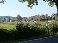
Gut Moor is located in the marshland on the edge of the Elbe glacial valley and consists almost entirely of meadow . The area is located on the edge of the Elbe glacial valley, directly at the transition to the Geest . In the area of Gut Moor, breeding activities and successful young rearing of white storks have been observed.
Waters
The Seevekanal flows on the southwestern edge of Gut Moors and branches off the Seeve at the Hörstener Wehr west of the Maschen marshalling yard and flows into the Süderelbe in Harburg . Other bodies of water are the Neuländer Wetter along the Großmoordamm dam and the Grüner Damm Wetter . The latter limits the district to the north.
Settlement structure
The main street of the district is the Großmoordamm , on one side there are lots with houses. There is a drainage ditch opposite the row of houses .
Neighboring districts of Hamburg
Gut Moor mainly borders on the districts of Hamburg-Neuland (north) and Hamburg-Rönneburg (south) as well as a short stretch of Hamburg-Harburg (west). In the east, the border with is Lower Saxony , behind which the community town of Großmoor the municipality Seevetal ( district of Harburg is located).
politics
For the election to the Hamburg citizenship and the district assembly , Gut Moor belongs to the Harburg constituency , results are summarized with Neuland .
Transport and infrastructure
The Großmoordamm ends in the west at federal highway 75 and is continued by federal highway 73 . The Federal Motorway 1 runs through Gut Moor for a length of 615 m .
Gut Moor is served by the public bus line 245 of Hamburger Hochbahn AG . There are the stops Großmoordamm 121 , Großmoordamm 181 , Großmoordamm 223 and Fünfhausener Straße (south) with Groß Moor and the Hamburg-Harburg train station .
Allotment garden association in Gut Moor

Hof am Großmoordamm


See also
Web links
- District statistics (PDF; 3.4 MB) of all Hamburg districts (as of 2010)
- Gut Moor on the side of the city of Hamburg
swell
- ^ Daniel Tilgner (ed.): Hamburg from Altona to Zollenspieker. The Haspa manual for all districts of the Hanseatic city. Hoffmann and Campe, Hamburg 2002, ISBN 3-455-11333-8 , p. 406.
- ^ Kausche, Dietrich: Harburg Hereditary Register from 1667 . Hamburg (Association for Hamburg. History), 1987, ISBN 3-923356-12-9 . P. 51
- ↑ a b Statistical Office for Hamburg and Schleswig-Holstein: City district database ( memento of the original from June 17, 2008 in the Internet Archive ) Info: The archive link was automatically inserted and not yet checked. Please check the original and archive link according to the instructions and then remove this notice.
- ↑ Final result of the 2020 citizenship election (PDF; 85 kB).
Altenwerder | Cranz | Eißendorf | Francop | Well moor | Harburg | House break | Heimfeld | Langenbek | Marble peat | Moorburg | Neuenfelde | Neugraben-Fischbek | New territory | Rönneburg | Sinstorf | Wilstorf