
Hamburg-Altenwerder
|
district of Hamburg |
|
|---|---|
  |
|
| Coordinates | 53 ° 30 '25 " N , 9 ° 55' 4" E |
| Residents | 3 (Dec 31, 2019) |
| Post Code | 2 .... |
| prefix | 040 |
| district | Harburg |
| Transport links | |
| Highway |
|
| Source: Statistical Office for Hamburg and Schleswig-Holstein | |

Altenwerder (spelling until 1946: Altenwärder ) is a Hamburg district in the Harburg district . The former village became a port expansion area in the 1960s. The residents were relocated; In 1998 the last residents left the district. Only the Altenwerder church is left of the old building ; today it belongs to the Hausbruch parish .
In 2003 the long-planned Altenwerder container terminal (CTA) went into operation. Today, the logistics halls and container cranes of the container terminal, the Sandauhafen north of it with the Hansaport for bulk goods, the Rugenberger Damm waste incineration plant on the Köhlbrand Bridge and two wind turbines characterize the district. To the east of the A7 motorway are the Alte Süderelbe marshalling yard as well as industrial plants and warehouses such as the Trimet aluminum works (formerly HAW - Hamburger Aluminum Werk) and the aluminum rolling mill of Hydro Aluminum Deutschland GmbH ( Norsk Hydro ).
Geographical location
To the north of Altenwerder is the district of Finkenwerder and Waltershof ( district of Hamburg-Mitte ), to the east of Wilhelmsburg (district of Hamburg-Mitte), to the south of Moorburg and to the west of Francop .
history


The island of Altenwerder was separated from the then diked Elbe island of Gorieswerder by the Allerkind flood in 1248 . The oldest surviving documents that mention the village of Altenwerder have no date, but historians have dated them to around 1250. In addition, loan registers of the Corvey Monastery give indirect evidence that Altenwerder could have been used or settled before 844. The name, shown in the early documents as Oldenwerdere , is justified by the fact that this Elbe island was settled earlier and longer than Finkenwerder or Silrandiswerder, where Werder means river island.
As parts of the country had become uninhabitable due to a series of storm surges, including the Cecilia flood , Altenwerder was re-diked on the basis of a treaty dated February 27, 1418 by the two rulers of the Archbishop of Bremen and the Dukes of Braunschweig and Lüneburg . In the 15th century, the Elbe island was farmed by sixteen farms alone. It is documented that Altenwerder had its own church as early as 1436, the parish of Altenwerder is first mentioned in 1468 , the first pastor mentioned by name is Hinrich Pruns († 1575), a new church was built in 1659.
At the beginning of the 16th century, the settlement of Köthners was permitted, who had to pay the farmhands for the use of the land and were available for repairs and construction work on the approximately 6 km long dike for a daily wage. Through the division of inheritance and the purchase of land, a multi-layered structure was created, ranging from independent full farms to small köthners who could no longer support themselves from agriculture alone. The houses of the Höfner were built in the style of the thatched Lower Saxony house, which was also the original shape of other houses in the village.
The dike divided the country into inland and outer dike land. In the inner dike there were vegetable, fruit and arable land, outside the dyke meadows and pastures. The dike cap was expanded to a wide driveway. The elevated building site on the dykes was a good place to build the houses. On the narrow island of Altenwerder, the north dike was the house dike. The individual possessions extended from there to the southern dike. Newer houses were also built on the outside of the dike or more outer dike on a mound , but they were thus more vulnerable to storm surges. The interior of the island was by blocks ( Querweg developed).
Documents from the Harburg district from 1678 mention two Vollhöfner, five Halbhöfner, nine Kohter and nine Brincksitzer in the Vogtey Altenwerder . Around 1756, in addition to 15 Vollhöfners and 2 Halbhöfners, 69 Köthners were named in Altenwerder.
A new church from 1769 was badly damaged in a very severe storm surge in 1825. A new church was built and inaugurated in 1831. The new building did not have a bell tower; the bells were placed in a wooden belfry in front of the church. The bell tower was not built until 1895.
In 1803 133 residential buildings and 1000 inhabitants are given, including 14 Vollhöfner, 2 Halbhöfner, 9 Großköthner and 81 Kleinköthner; the milk from the 400 or so cows that were kept at that time was transported to Hamburg with so-called Evern to be sold there. The total area of Altenwerder was determined in 1910 to be 825 hectares , of which 110 hectares were arable, 521 hectares were pasture and 194 hectares were wasteland. A census from June 16, 1925 identified 243 inhabited houses with 493 households and 2010 inhabitants in Altenwerder. A cattle census from December 1, 1924 found cattle husbandry in 255 households, specifically 146 horses, 538 cattle, 23 sheep, 517 pigs, 41 goats, 11 geese, 309 ducks and 2550 chickens. In 1937 Altenwerder, like some other communities in the Prussian district of Harburg, became part of Hamburg through the Greater Hamburg Act .
As a local supplier for the city of Hamburg, the residents of Altenwerder lived from growing vegetables, dairy farming, fishing and handicrafts. Since the 19th century more fruit was grown. With the gradual transformation of the islands into port and industrial areas in the 20th century, the islanders created new opportunities to earn a living. The pristine landscape and the isolated island life were lost at the same time.
The transport connection was made through the HADAG ship line Hamburg-Landungsbrücken - Neuhof - Moorburg - Harburg until the 1970s .

During the Second World War, the church was badly damaged by an air mine on April 8, 1945 in one of the last air raids. It was restored under the committed management of building inspector Andeus Bleß and on October 8, 1948, it was one of the first churches in the Hamburg area to be consecrated again.
As a consequence of the passage of the law to expand the port, the city of Hamburg bought properties from around 1960 and relocated the residents. An expropriation was announced between 1973 and 1978, which is why many people were persuaded to move, some with compensation. Today's Altenwerder has almost no residents. The remaining church and its cemetery are near the Elbmarsch high road (A7 motorway) in a green strip with old trees.
Two Enercon E-126 wind turbines have stood here since 2009, each with 6 megawatts and a total height of 198.5 meters among the tallest structures in the Hanseatic city.
In May 2016 it was announced that the Senate wanted to cut down the Vollhöfener Weiden in favor of new logistics areas as part of the port expansion "Altenwerder-West". There are 23,000 willow trees on the 45 hectare area . Environmental associations brought an action at the Hamburg administrative court. You see in the natural area an important habitat for rare species such as yellow mockers , small woodpeckers and water bats .
Population development
| 1803 | 1894 | 1925 | 1951 |
| about 1000 | 1394 | 2010 | 2563 |
| 1987 | 1988 | 1989 | 1990 | 1991 | 1992 | 1993 | 1994 | 1995 | 1996 | 1997 | 1998 | 1999 |
| 76 | 74 | 67 | 90 | 105 | 421 | 410 | 319 | 324 | 130 | 52 | 37 | 23 |
| 2000 | 2001 | 2002 | 2003 | 2004 | 2005 | 2006 | 2007 | 2008 | 2009 | 2010 | 2011 | 2017 |
| 1 | 12 | 0 | n / A | 0 | 0 | 2 | 2 | 3 | 3 | 3 | 3 | 3 |
Origin of the data: 1803, 1894, 1925, 1951, 1987-2017
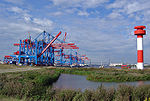
The Altenwerder port terminal in September 2004

2009 wind power plant under construction. Behind the church tower.

Hub of the wind turbine in front of container cranes of the CTA


See also
- List of streets and bridges in Hamburg-Altenwerder
- List of cultural monuments in Hamburg-Altenwerder
- List of stumbling blocks in Hamburg-Altenwerder
Web links
- Hamburg Altenwerder - a village disappears, on geschichtsspuren.de (formerly lostplaces.de)
- History of Altenwerder on www.rettet-die-elbe.de
- History and photos of Altenwerder
- Photos by Altenwerder from 1984/85 (private site)
Individual evidence
- ↑ a b Hamburg district office in cooperation with the Hamburg cultural authority - Monument Protection Office -: Altenwerder , Hamburg, 1981
- ^ Horst Beckershaus: The names of the Hamburg districts. Where do they come from and what they mean , Hamburg 2002, ISBN 3-434-52545-9 , p. 10
- ↑ G. Wülfken: was so beautiful Altenwerder , published by Uwe autumn, Neugraben, 1989
- ↑ a b c d H. L. Ballauf: The island of Altenwerder near Hamburg and Altona , Hahn brothers, Hanover, 1803
- ↑ a b c H. Laue and H. Meyer: Between Elbe, Seeve and Este , Verlag Gustav Elkan, Harburg / Elbe, 1925, p. 462 ff
- ↑ Angelika Hillmer: The world's most powerful wind turbines rotate on the A 7, Hamburger Abendblatt, August 22, 2009
- ↑ Conservationists complain against port expansion. (HTTPS) In: ndr.de. May 20, 2016. Retrieved May 24, 2016 .
- ↑ Gernot Knödler: Forest should give way to "logistics location" - lawsuit against port expansion. (HTTPS) In: taz.de. May 22, 2016, accessed May 30, 2016 .
- ↑ a b Journal for Ethnology, Volume 80–81, Berlin Society for Anthropology, Ethnology and Prehistory, German Society for Anthropology, Ethnology and Prehistory, German Society for Ethnology, 1955, page 129
- ↑ Statistical Office for Hamburg and Schleswig-Holstein, online database. Retrieved September 13, 2018 . Population Harburg district, Altenwerder district
- ↑ 30 years ago almost all residents had to make way for the port expansion. Bärbel and Bernd Uliczka stayed - in their trucker meeting place. Retrieved May 19, 2020 .
Altenwerder | Cranz | Eißendorf | Francop | Well moor | Harburg | House break | Heimfeld | Langenbek | Marble peat | Moorburg | Neuenfelde | Neugraben-Fischbek | New territory | Rönneburg | Sinstorf | Wilstorf