
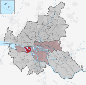
Hamburg-Waltershof
|
district of Hamburg |
|
|---|---|
  |
|
| Coordinates | 53 ° 31 '40 " N , 9 ° 54' 2" E |
| surface | 9.3 km² |
| Residents | 0 (Dec. 31, 2019) |
| Population density | 0 inhabitants / km² |
| Post Code | 21129 |
| prefix | 040 |
| district | Hamburg-center |
| Transport links | |
| Highway |
|
| Source: Statistical Office for Hamburg and Schleswig-Holstein | |
Waltershof ( Low German : Waltershoff ) is a district in the Hamburg-Mitte district of the Free and Hanseatic City of Hamburg . It is located in the western part of the Port of Hamburg , consists almost exclusively of port and industrial facilities and therefore has no residents.
geography
Geographical location
The former island of Waltershof is located on the south bank of the North Elbe, west of the confluence of the Köhlbrand and consists of the former islands of Griesenwerder , Mühlenwerder, Maakenwerder and Rugenbergen . Griesenwerder was Holstein until 1768 and came to Hamburg with the Gottorf Treaty , while Rugenbergen was already Hamburg in the 15th century. Waltershof was named in 1788 after the Hamburg Senator Walter Beckhoff . After the storm surge in 1962 , in which 37 people were killed in Waltershof, the island was given up as a settlement area.
To the south and west, Waltershof was bounded by the Köhlfleet (cf. Fleet ). In 1910 it was decided to use Waltershof as a port expansion area. In the course of this, the southeastern part of the Köhlfleet was filled in in the middle of the 20th century, so that Waltershof today forms a peninsula that connects to the neighboring Altenwerder to the south . The approach of the southern arm of the Köhlfleet is today the Sandauhafen harbor . The Köhlfleet and the Kleine Aue still demarcate the Waltershof peninsula from the Finkenwerder peninsula to the west .

A large part of the Waltershof area consists of harbor basins. The Parkhafen lies on the main stream of the (Norder-) Elbe , from which the Petroleumhafen to the west , the Waltershofer Hafen to the southeast and, formerly, the Griesenwerder Hafen to the south . In the northeast of the peninsula, southeast of the Maakenwerder port (a former connection - known as Kaisers Loch - to the Köhlbrand , which is separated from it by the Maakendamm ), is the southern access ramp of the new Hamburg Elbe tunnel .
The initially buoyant sealed concrete elements for the first three tubes of the tunnel were manufactured as a composite at that time - only the western fourth tube was driven by shield driving (see TRUDE ) - and were poured in the dammed and drained Maakenwerder harbor , which was then almost completely filled in ; The oldest Hamburg Container Terminal Burchardkai (CTB) was built on this area .
By Walter Hofer Harbor , there is a passage for small Rugenberger port (below the west ramp of the Köhlbrandbrücke ) defined by the Rugenberger lock is connected to the Köhlbrand. Today the Dradenauhafen can only be reached from the Köhlfleet with its Köhlfleet port ; Waltershof only became a peninsula when the connection to the Köhlbrand was filled in.
Neighboring districts
In the north, the Waltershof district borders on the districts of Othmarschen , Ottensen and Altona-Altstadt on the other side of the Norderelbe , in the east on Steinwerder beyond the Köhlbrand, in the south on Altenwerder and in the west on Finkenwerder .
politics
For the election to the citizenship , Hamburg-Waltershof belongs to the constituency of Billstedt-Wilhelmsburg-Finkenwerder . Due to the low number of voters in the district, the results are determined together with Hamburg-Finkenwerder and are listed in the article there.
Economy and Infrastructure
traffic


The southern ramp of the new Elbe tunnel with a junction of the A 7 is located in Waltershof .
Since 1974, the Köhlbrand Bridge, with a passage height of 54 meters, has connected Waltershof with the neighboring island of Neuhof to the east in the Steinwerder and Wilhelmsburg districts . The bridge was part of the free port , the eastern and western parts of which it connected; it is only approved for motor vehicles . Before that, two congested trajectories fulfilled this important connection task over the Köhlbrand, but pedestrians and cyclists could also use them.
The Hamburg-Waltershof freight yard of the Hamburg port railway is located in Waltershof , with extensive track systems running through the district; There are no railway systems for passenger traffic here.
The ferry 61 connects Waltershof with the Landungsbrücken.


Public facilities
In 1889 the Hamburg seaman's school , which was previously located in Hamburg-Steinwerder , came to Waltershof. The school was run as a foundation and trained students between the ages of 13-17 years in a two-year training course to become drivers. The seaman's school moved to Hamburg-Finkenwerder in 1913 .
On the northwest tip Waltershofs, the Seemannshöft that are pilot station Seemannshöft with its characteristic radar tower and the Hamburger Schiffsmeldedienst resident. The Dradenau sewage treatment plant is also located in the district, with its “dragon eggs” of the Hamburg city drainage system that can be seen from afar .
The Waltershof customs office operates one of the world's most modern container testing systems with the option of screening entire containers in one piece. In 2020, around 1.5 tons of cocaine were discovered in a container here , one of the largest finds in the history of the Hamburg port. It was hidden between sacks of Guiana rice . Further customs stations are located on Zellmannstrasse and on Köhlfleetdamm .
The International Sailor Club Duckdalben of the German Sailor Mission Hamburg-Harburg eV is also on Zellmannstrasse . As a facility with a wide variety of offers, it is aimed at seafarers from all over the world and is intended to offer a pleasant place to stay in the port area during the short lay times.
economy
Until the beginning of 2013 , the northeast of Waltershof was designated as a free port , that is to say as a “free zone of control type I” under customs law, and formed the newer, western part of the former Hamburg free port . There are two extensive container terminals here for handling goods with containers to and from seagoing vessels.
The older facility is the container terminal Burchardkai (CTB) of HHLA with the Burchardkai (on the northeast side of the Waltershofer Hafen and east of the Parkhafen ) and with the Athabaskakai on the Norderelbe.
The second large facility is the Eurogate terminal with the Predöhlkai on the southern side of the Waltershofer Hafen . It was expanded in the 1990s and the Griesenwerder harbor (with the berths at Stoltenkai and Diestelkai ) was filled in for it. This Container Terminal Hamburg (CTH) is to be expanded to the northwest on the site of a refinery that was abandoned in the early 1990s , partially backfilling the petroleum port as far as the North Elbe.
At the terminals, numerous companies are active, the largest are the HHLA (HHLA) and the Eckelmann Group belonging Eurokai KGaA .
Outside the free port area, in the vicinity of the petroleum port, there are large tank systems for petroleum products and alcohol. Opposite the Dradenau sewage treatment plant is a small steelworks belonging to the ArcelorMittal group of companies in Hamburg , which produces steel from scrap and sponge iron and is also accessible from the waterfront with the Amsterdam quay at Dradenauhafen .
Hansaport Hafenbetriebsgesellschaft mbH operates a bulk cargo handling facility for iron ore and coal at Sandauhafen .
The aluminum factory of the former Reynolds / HAW on Finkenwerder Straße , like the Alte Süderelbe freight yard , is already in the Altenwerder district .
In Waltershof are since 2011 two wind turbines of the type Nordex N100 with 140 meters hub height, 100 meters in diameter and 2.5 megawatts.
Publications
- Johannes Tönnies: From Walters-Hof to the container terminal: the Elbe island Waltershof, Hamburg 2012
See also
Web links
Individual evidence
- ^ Franklin Kopitzsch , Daniel Tilgner (ed.): Hamburg Lexikon. 4th, updated and expanded special edition. Ellert & Richter, Hamburg 2010, ISBN 978-3-8319-0373-3 , p. 620.
- ↑ https://www.sueddeutsche.de/panorama/hamburg-hafen-zoll-kokain-1.4994850
- ↑ https://www.sueddeutsche.de/panorama/hamburg-hafen-zoll-kokain-1.4994850
Billbrook | Billstedt | Borgfelde | Finkenwerder | HafenCity | Hamburg old town | Hamm | Hammerbrook | Horn | Little Grasbrook | Neustadt | Neuwerk | Rothenburgsort | Steinwerder | St. George | St. Pauli | Veddel | Waltershof | Wilhelmsburg