
Hamburg Francop
|
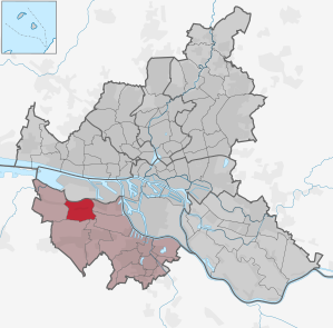
district of Hamburg |
|
|---|---|
  |
|
| Coordinates | 53 ° 30 '29 " N , 9 ° 51' 10" E |
| surface | 9.1 km² |
| Residents | 715 (Dec. 31, 2019) |
| Population density | 79 inhabitants / km² |
| Post Code | 2 .... |
| prefix | 040 |
| district | Harburg |
| Source: Statistical Office for Hamburg and Schleswig-Holstein | |

Francop is a district of the Free and Hanseatic City of Hamburg in the Harburg district . The district belongs to the old country .
geography
expansion
All of Francop's houses are on a long street. However, the street changes name several times. From west to east: Forty pieces, Hohenwischer Strasse, Hinterdeich.
Neighboring districts
Finkenwerder borders on Francop to the north in the Hamburg-Mitte district , to the east on Altenwerder , south-east on Moorburg and Hausbruch , south on Neugraben-Fischbek and west on Neuenfelde .
history

The first written mention of Francop comes from the year 1235, but the origin of the village is assumed earlier, in the middle of the 12th century. The name refers to a man named Franko or Franke as the founder of the village. The suffix -cop or -koop comes from Middle Dutch and goes back to settlement officials who, on behalf of the manor, recruited colonists who often came from the Netherlands in the southern Elbmarsch . For etymology see also: Boskoop (Netherlands) (section: History).
On August 1, 1932, Frankop was incorporated from the dissolved Jork district into the Harburg district.
In 1937, Francop, like some other communities in the Prussian district of Harburg, became part of Hamburg through the Greater Hamburg Law .
statistics
- Minor quota: 15.2% [Hamburg average: 16.3% (2017)].
- Elderly rate: 17.9% [Hamburg average: 18.2% (2017)].
- Proportion of foreigners: 10.9% [Hamburg average: 17.1% (2017)].
- Unemployment rate: 1.6% [Hamburg average: 5.2% (2017)].
The average income per taxpayer in Francop is 35,782 euros annually (2013), the Hamburg average is 39,054 euros.
politics
For the election to Hamburg citizenship , Francop belongs to the constituency of the Süderelbe .
Election results
| Citizenship election | SPD | CDU | FDP | Green 1) | left | AfD | Rest |
|---|---|---|---|---|---|---|---|
| 2015 | 41.0% | 26.3% | 13.9% | 6.1% | 6.0% | 4.3% | 2.4% |
| 2011 | 45.4% | 31.5% | 13.7% | 4.5% | 1.5% | - | 3.4% |
| 2008 | 25.9% | 59.3% | 5.5% | 4.5% | 3.1% | - | 1.7% |
| 2004 | 23.5% | 59.3% | 3.7% | 6.6% | - | - | 6.9% |
| 2001 | 23.0% | 38.1% | 9.0% | 5.2% | 0.3% 2) | - | 24.4% 3) |
| 1997 | 36.8% | 35.8% | 4.7% | 9.0% | - | - | 13.7% 4) |
| 1993 | 38.7% | 36.4% | 5.9% | 6.6% | - | - | 12.4% 5) |
| 1991 | 43.2% | 46.2% | 3.0% | 3.6% | - | - | 4.0% |
| 1987 | 39.7% | 52.4% | 4.5% | 3.2% | - | - | 0.2% |
| 1986 | 35.3% | 52.9% | 4.0% | 6.3% | - | - | 1.5% |
| Dec 1982 | 38.8% | 52.8% | 2.8% | 5.6% | - | - | - |
| June 1982 | 32.1% | 56.5% | 2.8% | 8.1% | - | - | 0.5% |
| 1978 | 42.6% | 49.6% | 4.9% | 1.5% | - | - | 1.4% |
| 1974 | 34.9% | 52.0% | 11.7% | - | - | - | 1.4% |
| 1970 | 44.7% | 41.2% | 7.8% | - | - | - | 6.3% 6) |
| 1966 | 39.5% | 48.4% | 7.1% | - | - | - | 5.0% 7) |
1) 1978 as a colorful list - defend yourself , 1982 to 2011 as Greens / GAL.
2) As PDS / Left List.
3) Including 22.7% for the Schill party .
4) Including 5.3% for the DVU .
5) Including 6.6% for The Republicans .
6) Including 6.0% for the NPD .
7) NPD.
Culture and sights

There are many old half-timbered houses in Francop .
Economy and Infrastructure

The Francoper live mainly from fruit growing .
traffic
Two HVV bus lines operate in Francop, the line 157 Harburg - Moorburg - Hohenwisch and the line 257 S-Neugraben - Francop - Neuenfelde - Jork.
Personalities
- Wilhelm Mohr (1912–2000), typesetter and Low German author
See also
Web links
- District statistics; Francop on page 221 f. (PDF; 3 MB)
Individual evidence
- ^ Horst Beckershaus: The names of the Hamburg districts. Where do they come from and what they mean , Hamburg 2002, ISBN 3-434-52545-9 , p. 43
- ^ Prussian State Ministry, § 66, Ordinance on the reorganization of districts, from August 1, 1932 Preußische Gesetzessammlung, Berlin 1932; No. 43 , R. von Deckers Verlag, G. Schenk, 1932, pages 255-273
- ↑ Quota of minors in the Hamburg districts in 2017
- ↑ Proportion of 65-year-olds and older in the Hamburg districts in 2017
- ↑ Proportion of foreigners in the Hamburg districts in 2017
- ↑ Unemployment rate in the Hamburg districts in 2017
- ↑ Statistical Office for Hamburg and Schleswig-Holstein (ed.): Hamburg District Profile 2016 (= NORD.regional . Volume 19 ). 2018, ISSN 1863-9518 ( Online PDF 6.6 MB [accessed February 12, 2018]).
Altenwerder | Cranz | Eißendorf | Francop | Well moor | Harburg | House break | Heimfeld | Langenbek | Marble peat | Moorburg | Neuenfelde | Neugraben-Fischbek | New territory | Rönneburg | Sinstorf | Wilstorf