
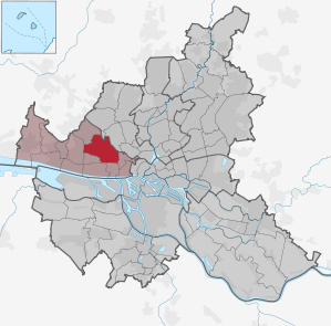
Hamburg-Bahrenfeld
|
district of Hamburg |
|
|---|---|
  |
|
| Coordinates | 53 ° 34 '26 " N , 9 ° 53' 33" E |
| surface | 10.9 km² |
| Residents | 30,203 (Dec. 31, 2019) |
| Population density | 2771 inhabitants / km² |
| Post Code | 22 ... |
| prefix | 040 |
| district | Altona district |
| Transport links | |
| Highway |
|
| Federal road |
|
| Train |
|
| Source: Statistical Office for Hamburg and Schleswig-Holstein | |
Bahrenfeld is a district in western Hamburg . It belongs to the Altona district . Incorporated in 1938 with the whole of Altona in Hamburg, the district had over 26,000 inhabitants in 2008.
geography
In 2007, Bahrenfeld had an area of 10.5 km². It borders in the west on Osdorf , in the southwest on Groß Flottbek , in the south on Othmarschen and Ottensen , in the southeast on Altona-Nord , in the east on Stellingen and in the north on Eidelstedt and Lurup .
history
Bahrenfeld was first mentioned in 1256. For centuries it was a small farming village on the road from Hamburg to Pinneberg and belonged to the Holstein-Pinneberg rule for most of the time . In 1867 Bahrenfeld became Prussian and in the same year it was connected to the newly opened Altona-Blankeneser Railway . In the period that followed, the first industrial companies settled here; From 1910, extensive workers' settlements emerged on the border with Ottensen.
Already in 1890 Bahrenfeld was incorporated into Altona / Elbe , with which it became part of Hamburg under the Greater Hamburg Law in 1938. During the subsequent reorganization of the Hamburg district boundaries after the Second World War, Bahrenfeld was considerably expanded to include parts of the former Ottensener Feldmark (also called Neu-Ottensen) to the east. With this, the unified municipality of Hamburg adapted the new district boundaries of Bahrenfeld, Ottensen and Altona Nord to the boundaries of the track systems without referring to historical boundaries.
In 1923, the Reemtsma company relocated its cigarette production from Erfurt to Altona-Bahrenfeld in Prussia. From 1930 the British American Tobacco also produced in Bahrenfeld. After BAT moved out, the production facility was converted into Westend Village , a comfortable residential complex.
Since the opening of the federal highway 7 in the mid-1970s, however, Bahrenfeld has been cut into two parts, the old center around the Bahrenfeld market square has disappeared.
Population development
| 1840 | 1890 | 1914 | 1939 | 1956 | 2013 |
|---|---|---|---|---|---|
| 400 | 2,200 | 9,400 | 26,000 | 43,000 | 27,274 |
statistics
- Minor quota: 16.7% [Hamburg average: 16.3% (2017)].
- Elderly rate: 12.8% [Hamburg average: 18.2% (2017)].
- Proportion of foreigners: 24.0% [Hamburg average: 17.1% (2017)].
- Unemployment rate: 5.9% [Hamburg average: 5.2% (2017)].
The average income per taxpayer in Bahrenfeld is 33,565 euros annually (2013), the Hamburg average is 39,054 euros.
politics
For the election to the citizenry , Bahrenfeld belongs to the constituency of Altona . The 2015 state election led to the following result:
Culture and sights
Parks

The Altonaer Volkspark connects to the north of the Bahrenfeld trotting track . It is Hamburg's largest public park (205 hectares) and extends as far as Lurup, Eidelstedt and Stellingen.
The Bonnepark named after Georg Bonne is a large traffic island between the A 7 , B 431 and Bahrenfelder Chaussee. The Bonnehaus stood in Bonnepark , but Bonne never lived in it. It was built in 1895 by Carl Friedrich Gajen and used as a manor. The IOGT (International Organization of Good Templars) later moved into the house. After the seizure of power by the National Socialists, the premises were converted into a total of six different sized apartments. The Bonnehaus was demolished in the course of the new construction of the A 7.
There are several large cemeteries in Bahrenfeld. In addition to the Altona main cemetery at Volkspark, these are the Jewish burial ground on Bornkampsweg, the Mennonite cemetery on Holstenkamp and the Protestant cemeteries on Holstenkamp, Bornkamp and Diebsteich. All of these are tangible remnants of freedom of belief in Altona's history .
The grounds of the Lise-Meitner -Park at DESY (hence also: Desy-Wiesen ) were designed from soil that was left during the construction of the Hamburg Elbe Tunnel .
The Otto von Bahrenpark also includes a green area, but it designates a real estate property that includes a listed building ensemble of the former gasworks .
Other structures

The dahlia garden is one of the few tourist attractions in Bahrenfeld. Every year more than a quarter of a million visitors find their way into this free garden. It is part of the Altonaer Volkspark and is located on the corner of Luruper Chaussee and Stadionstrasse. The dahlia garden was inaugurated in 1920. It is 1½ hectare in size and with 14,227 dahlias it is Europe's dahlia garden with the most rarities. The season usually lasts from late June to late October (until the first frost).
On the northern edge of the Altonaer Volkspark are the sports arenas Barclaycard Arena , the former home of the now defunct DEL Club Hamburg Freezers and the handball club HSV Hamburg , which is now mainly used for concerts, and the Volksparkstadion , the venue of the former Bundesliga club and since 2018 in the 2 .Bundesliga playing Hamburger SV , as well as the ice and ball sports hall Volksbank Arena .
The Evangelical Luther Church (Bahrenfeld's first church, built in 1910), east of the Autobahn and Volkspark, is also worth a detour. In addition to the Luther Church, Bahrenfeld has two other Protestant churches, the Paul Gerhardt Church in the east of the district and the Free Evangelical Community of Hamburg-Bahrenfeld.
Economy and Infrastructure
traffic
Bahrenfeld is well connected to national road traffic. The federal motorway 7 runs through Bahrenfeld , at its exit no. 28 it intersects the federal road 431 , which crosses Bahrenfeld from east to west.
The emanating therefrom emissions , in particular noise, have led to that enshrined in the Bahrenfeld, Othmarschen and Great Flottbek citizens' initiative "Without Roof crash is" for years an over cap on the highway trench requested has worked on a financing and implementation concept and for that also finds cross-party support in local politics.
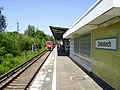
Bahrenfeld is with the train stations Bahrenfeld (border between Bahrenfeld and Ottensen ) on the railway line Hamburg-Altona-Wedel and Diebsteich (border between Bahrenfeld and Altona-Nord ) on the railway line Hamburg-Altona-Kiel and the City-S-Bahn Hamburg to the Network of the S-Bahn Hamburg (lines S 1, S 11, S 21, S 3) and the AKN ( line A1 ) connected.

Bahrenfeld S-Bahn station.
Diebsteich S-Bahn station.


In Bahrenfeld was the northern part of the rail network of the Ottensener Industriebahn , a connecting railway with roll-head traffic . Remnants of it can still be seen in the road surface.
Metrobus routes 1 (S-Rissen - S Blankenese - Schenefelder Holt - S Othmarschen - Altona station), 2 (Schenefeld, Achterndiek / Schenefeld, bus depot - Rugenbarg (north) - Trabrennbahn Bahrenfeld - Altona station) and 3 ( (Schenefelder Platz -) Stadionstraße - Rathausmarkt - Hbf - Tiefstack power station), the Xpressbus route X3 (Schenefelder Platz - Osdorfer Born - S Holstenstraße - U Feldstraße - U / S Jungfernstieg - U Meßberg), the express bus route 37 (Schenefelder Platz - Bramfeld, Dorfplatz ) as well as the city bus routes 180 (S-Stellingen - S-Holstenstraße), 283 (Elbe shopping center - Altona - Kalvslohtwiete), 284 (U Niendorf Nord - Rugenbarg (north) - AK Altona / Kressenweg) and 288 (Lutherpark care center - Fischmarkt) connect the district with downtown Hamburg and the regional center Hamburg-Altona.
Established businesses
Due to its favorable location, Bahrenfeld is the seat of various companies, especially in the service and processing sector. A large industrial and commercial area runs through the northeast of the district. The district statistics indicate the number of local handicraft businesses as 356 for 2007, compared with 281 in 2002.
- Audiolith Records
- Carl Kühne KG (Essig-Kühne) (only head office, production is now in six German plants as well as in France, Turkey and Poland)
- Jimdo
- The Hamburger Morgenpost newspaper (MOPO)
- The yacht outfitter AW Niemeyer
- Reyher screws
- Rotring
- Piano maker Steinway & Sons , today Steinway Musical Instruments
- Berendsohn AG
Public facilities
- The voluntary fire brigade Ottensen-Bahrenfeld has its office in Friesenweg.
- The THW local association Hamburg-Altona owned a site for its purposes on Notkestrasse until August 2011.
- The Hamburg police have set up police station 25 at Notkestraße 95 (formerly in Silcherstraße).
Research and education
The German Electron Synchrotron DESY in the Helmholtz Association , a world-renowned research institute for particle physics, maintains a research center in Bahrenfeld; Starting from the site, the now decommissioned HERA particle accelerator tunnels the northern part of Bahrenfeld. With around 1,800 employees, DESY is one of the largest employers in the district. In 1992, DESY received its second location, DESY Zeuthen, southeast of Berlin .
In addition, there are branch offices of the Max Planck Institute for the Structure and Dynamics of Matter , the Helmholtz Center Geesthacht and the European Molecular Biology Laboratory on the DESY site .
Six schools are located within the residential areas , including the Bahrenfeld district school (previously Bahrenfeld comprehensive school ) and a special school for handicapped children in Kielkamp. In 2007 there were 2,295 students in the district.
literature
- Martin Wendt: How Bahrenfeld became. From the Stone Age to today - the chronicle of a Hamburg district. In: 750 years of Bahrenfeld . Hamburg 2006 (Festschrift, published by the Bahrenfeld Citizens' Association).
- Johanna Wolff: walks through Bahrenfeld. Hamburg 1990 (results).
See also
- List of streets and squares in Hamburg-Bahrenfeld
- List of cultural monuments in Hamburg-Bahrenfeld
- List of stumbling blocks in Hamburg-Bahrenfeld
Web links
- Bahrenfeld on hamburg.de
- Bahrenfelder See
Individual evidence
- ↑ a b c website Statistics North, accessed October 15, 2009.
- ↑ Quota of minors in the Hamburg districts in 2017
- ↑ Proportion of 65-year-olds and older in the Hamburg districts in 2017
- ↑ Proportion of foreigners in the Hamburg districts in 2017
- ↑ Unemployment rate in the Hamburg districts in 2017
- ↑ Statistical Office for Hamburg and Schleswig-Holstein (ed.): Hamburg District Profile 2016 (= NORD.regional . Volume 19 ). 2018, ISSN 1863-9518 ( statistik-nord.de [PDF; 6.6 MB ; accessed on February 12, 2018]).
- ↑ Result of the 2015 mayor elections in the Hamburg districts, voter turnout and share of votes (state votes - total votes) of the parties in percent. (PDF; 94.9 kB) Statistical Office for Hamburg and Schleswig-Holstein, February 27, 2015, accessed on March 10, 2016 .
- ↑ Final result of the 2011 mayor election (state votes - total votes) in the Hamburg districts: voter turnout and votes of the parties in percent. (PDF; 60.6 kB) Statistical Office for Hamburg and Schleswig-Holstein, May 18, 2011, accessed on March 10, 2016 .
Altona old town | Altona-North | Bahrenfeld | Blankenese | Groß Flottbek | Iserbrook | Lurup | Nienstedten | Osdorf | Othmarschen | Ottensen | Cracks | Sternschanze | Sülldorf