
Hamburg-Hohenfelde
|
district of Hamburg |
|
|---|---|
  |
|
| Coordinates | 53 ° 33 '42 " N , 10 ° 1' 15" E |
| surface | 1.1 km² |
| Residents | 10,034 (Dec. 31, 2019) |
| Population density | 9122 inhabitants / km² |
| Post Code | 22087, 22089 |
| prefix | 040 |
| district | Hamburg North |
| Transport links | |
| Federal road |
|
| Subway |
|
| Source: Statistical Office for Hamburg and Schleswig-Holstein | |
Hohenfelde is a district on the Outer Alster in the Hamburg-Nord district of the Free and Hanseatic City of Hamburg . Hohenfelde lies between St. Georg in the west and Eilbek in the east, in the north it borders on the Uhlenhorst , in the south on Borgfelde .
history


Hohenfelde was pledged to the Hospital of the Holy Spirit in 1256 and transferred in a document by Count Adolf VI von Schauenburg in 1359. As early as 1375, the Landwehr was built as a defensive wall to secure the field mark, stretching from the Kuhmühlenteich down to the valley of the Hammer Brook. As a result of the Reformation , the property of the Hospital of the Holy Spirit was secularized in 1528 and initially administered by the 12 senior elders.
The so-called Hohe Feld was an area at the gates of the city that served as a glacis from 1679 , i.e. as a free field of fire in front of the city fortifications, and was not allowed to be built on. Until the Mundsburger Damm was filled in in Uhlenhorst, the Kuhmühle was the only bridge over the Eilbek , over which the villages of Barmbek and Winterhude could be reached from the Lübecker Tor . The main street of Hohenfelde was the Mühlendamm .
In 1773 Hohenfelde, which at the time was much larger than today's district, had an estimated 30 inhabitants. But already in 1810 there were 754 inhabitants in Hohenfelde. In the course of the expulsion of the Napoleonic troops from Hamburg, Hohenfelde was one of the last areas of retreat and suffered catastrophic destruction. In 1824, ten years later, the reconstruction was not yet completed and the population had dropped to 583 residents.
The modern settlement of Hohenfeld was favored by the Hamburg fire of 1842, which reduced a third of the old town to rubble, and the lifting of the gate lock in 1861, which made the old city limits freely passable. Until 1870, the development, mainly residential houses with trade, extended over the entire district, although not everywhere in a coherent form. In 1869 a beach bathing area was built on the banks of the Alster in Hohenfelde, which was initially reserved for men only, and in 1901 was given a separate women's pool. In 1874 Hohenfelde was incorporated into Hamburg and placed under municipal administration. In the year of incorporation, the watermill, first mentioned in 1247, which as a grain mill was one of the most important utilities of the time, was demolished and replaced by a bridge that is still called Kuhmühle today .
The Lübeck Gate was a city gate in the ramparts of the Hamburg suburb of St. Georg. It got its name because the road to Lübeck once began here. The last remnants of the moat were filled with rubble after the Second World War and the Sechslingspforte road was built on it . This street name is reminiscent of a “side entrance” in the city fortifications at the level of Buchtstraße . The connection also served as a connection from St. Georg to the fire pit in the Alster Bay. The way to Uhlenhorst once led through the gate. In 1852 a private stock corporation laid out a footpath from the Lohmühle along the Alster to shorten the route. The raised a sextuplet from the users as a kind of " toll ". In 1869 the road toll was abolished.
From 1839 the Basson horse buses ran from the town hall through Hohenfelde to the Wandsbeker Zoll. Since 1842, Hermann Schulz's horse-drawn bus also drove daily from the pig market to the Barmbeker market on the Dehnheide. From 1867 the red and white Soltauschen buses were used to connect Hohenfelde with St. Pauli. The S-Bahn has been running with the Landwehr station since 1906 and the ring line with the Lübecker Strasse and Uhlandstrasse stations since 1912 . Until the war-related destruction, there was an important junction of the Hamburg tram not far from the Uhlandstraße train station . After the Second World War, the hub of having transport to Metro Station Mundsburg shifted in Uhlenhorst. With the increasing introduction of buses, tram lines 19 and 35 and the Alsterring line from Hohenfelde disappeared in the 1960s.
As a result of Operation Gomorrah in 1943, 70 percent of the Hohenfelde housing stock was destroyed in the Second World War. At times there was no water, electricity or gas. The street trees were sawed off for heating. The remaining apartments were overcrowded and many residents were evacuated. After the war, the bunker on Hinrichsenstrasse was made available as emergency accommodation. With the reconstruction of Hohenfelde between 1950 and 1960, the structural aspect changed considerably. Hohenfelde achieved supra-regional importance through the construction of the Alster swimming pool in 1968.
statistics
- Minor quota: 12.2% [Hamburg average: 16.3% (2017)].
- Elderly rate: 15.8% [Hamburg average: 18.2% (2017)].
- Proportion of foreigners: 19.6% [Hamburg average: 17.1% (2017)].
- Unemployment rate: 4.4% [Hamburg average: 5.2% (2017)].
The average income per taxpayer in Hohenfelde is 39,541 euros annually (2013), the Hamburg average is 39,054 euros.
politics
For the election to Hamburg citizenship and the district assembly , Hohenfelde belongs to the constituency of Barmbek-Uhlenhorst-Dulsberg .
Election results
| Citizenship election | SPD | Green 1) | CDU | Left 2) | FDP | AfD | Rest |
|---|---|---|---|---|---|---|---|
| 2015 | 44.6% | 14.4% | 12.9% | 9.4% | 8.8% | 5.4% | 4.1% |
| 2011 | 46.7% | 14.6% | 19.2% | 6.6% | 7.6% | - | 5.3% |
| 2008 | 33.0% | 11.2% | 42.1% | 6.9% | 4.9% | - | 1.9% |
| 2004 | 32.0% | 15.0% | 45.1% | - | 3.3% | - | 4.6% |
| 2001 | 37.8% | 11.5% | 26.0% | 0.6% | 5.6% | - | 18.5% 3) |
| 1997 | 34.8% | 18.3% | 28.7% | 0.8% | 3.9% | - | 13.5% |
| 1993 | 41.3% | 15.6% | 24.4% | - | 4.2% | - | 14.5% 4) |
| 1991 | 46.2% | 8.9% | 34.9% | 0.7% | 5.5% | - | 3.8% |
| 1987 | 42.2% | 8.6% | 41.8% | - | 6.2% | - | 1.2% |
| 1986 | 36.4% | 12.8% | 44.5% | - | 5.1% | - | 1.2% |
| Dec 1982 | 45.6% | 8.6% | 41.9% | - | 2.9% | - | 1.0% |
| June 1982 | 36.8% | 9.7% | 46.4% | - | 4.8% | - | 2.3% |
| 1978 | 44.4% | 4.5% | 42.1% | - | 6.5% | - | 2.5% |
| 1974 | 34.3% | - | 48.7% | - | 12.8% | - | 3.8% |
| 1970 | 47.6% | - | 40.3% | - | 7.0% | - | 5.1% |
| 1966 | 47.5% | - | 39.7% | - | 8.0% | - | 4.8% |
1) 1978 as a colorful list - defend yourself , 1982 to 2011 as Greens / GAL.
2) 1991 and 1997 as PDS / Linke Liste, 2001 as PDS.
3) Including 15.1% for the Schill party .
4) Including 5.2% for the Instead of Party .
Culture and sights

South side of the Alster swimming pool

Marien Hospital

Canoe polo in the Alster Bay

"Three men in a boat" bronze sculpture by Edwin Scharff on the banks of the Outer Alster

The Faculty of Design at the Hamburg University of Applied Sciences , Wartenau 15
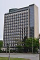
High-rise Lübecker Straße 1, Alster-Tower, Neue Heimat -Haus, architect: Ernst May


.1.ajb.jpg)
traffic
Public transport connection

In Hohenfelde there are the subway stations Lübecker Straße (U1 / U3), Uhlandstraße (U3) and Wartenau (U1) as well as the S-Bahn station Landwehr (S1 / S11). The Metrobus routes 6 (Borgweg → Speicherstadt / Feldstrasse) and 25 (Altona → Winterhude → Hammerbrook), as well as the city bus routes 172 (Mundsburger Brücke → Barmbek → Ohlsdorf → Hummelsbüttel) and 173 (Mundsburger Brücke → Barmbek → Bramfeld) also run through Hohenfelde. There are also express bus routes 35 (Hamburg Messe → Rathausmarkt → Wandsbek → Jenfeld → Rahlstedt) and 36 (Blankenese → Altona → Rathausmarkt → Wandsbek → Farmsen), as well as night bus routes 607 (St. Pauli → Rathausmarkt → Barmbek → Poppenbüttel → Volksdorf) and 608 (St. Pauli → Rathausmarkt → Wandsbek → Rahlstedt) through this district.
Private transport
High field is strongly influenced by the main roads Wallstrasse-Steinhauerdamm-Lübeckerstraße ( B 75 ), Wartenau ( B 5 ), Schwanenwik -Mundsburger dam and Mühlendamm- Kuhmühle cut and through it and extending on the border of St. Georg Sechslingspforte with noise and exhaust gases burdened.
literature
- C. Albrecht: From the high field to Hohenfelde. Published by neuspar on the 40th anniversary of its branch Lübecker Straße 11, Hamburg 1966, OCLC 248081155 .
- Ulrich Bauche : Hamburg in historical aerial photographs. Braunschweig 1980, ISBN 3-14-508975-7 .
- HJ Behnke, K.-G. Evers, K. Möller: Area renovation of a residential area - The restructuring in Hamburg-Hohenfelde. West Berlin 1976.
- U. Emmenthal: Hohenfelde. A district-sociological study of its usage and social structure based on resident and expert interviews. Diploma thesis . Hamburg 1987, OCLC 256978822 .
- H. Hinrichsen: The past from Eilbek and Hohenfelde. Hamburg 1981, ISBN 3-920610-49 .
- J. Strege: 100 years of St. Gertrud Hamburg 1885–1985. Hamburg 1985, OCLC 27917249 .
- Rainer Ahlers: Sankt Georg Buch - with Borgfelde, Hohenfelde, Hammerbrook and Hamm. Junius Verlag, Hamburg 2015, ISBN 978-3-88506-059-8 .
Web links
- Hohenfelde on hamburg.de
- Hohenfelder and Uhlenhorster citizens' association
- Hohenfelde district development concept
Individual evidence
- ↑ Map of the destruction in 1945
- ↑ Quota of minors in the Hamburg districts in 2017
- ↑ Proportion of 65-year-olds and older in the Hamburg districts in 2017
- ↑ Proportion of foreigners in the Hamburg districts in 2017
- ↑ Unemployment rate in the Hamburg districts in 2017
- ↑ Statistical Office for Hamburg and Schleswig-Holstein (ed.): Hamburg District Profile 2016 (= NORD.regional . Volume 19 ). 2018, ISSN 1863-9518 ( Online PDF 6.6 MB [accessed February 12, 2018]).
Alsterdorf | Barmbek-North | Barmbek-Süd | Dulsberg | Eppendorf | Fuhlsbüttel | Groß Borstel | Hoheluft-Ost | Hohenfelde | Langenhorn | Ohlsdorf | Uhlenhorst | Winterhude