Motorway triangle Norderelbe
| Motorway triangle Norderelbe | |
|---|---|
|
|
|
| map | |
| location | |
| Country: | Germany |
| State : | Hamburg |
| Coordinates: | 53 ° 30 '31 " N , 10 ° 2' 10" E |
| Height: | 3 m above sea level NN |
| Basic data | |
| Design type: | Left-hand trumpet |
| Bridges: | 1 (motorway) |
| Construction year: | 1963 |
| The A1 from Lübeck before the triangle | |
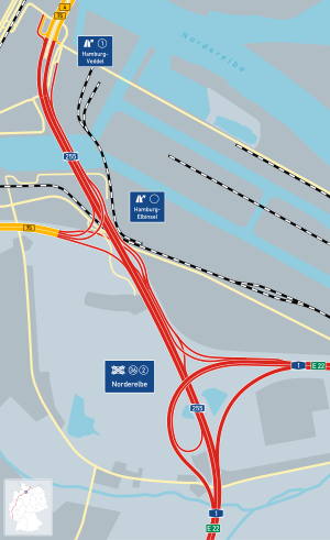
The motorway junction Norderelbe (short triangle Norderelbe until 6 October 2019 junction Hamburg-Süd , shortly Hamburg-South ) is a highway junction in Hamburg . It connects the federal highway 1 ( Hansalinie ; E 22 ) with the federal highway 255 ( Veddel junction ).
As part of the downgrading of the A 252 to B 75 on October 6, 2019, the previous cross was Hamburg-Süd in Autobahndreieck Norderelbe renamed.
geography
The motorway triangle is located in the city of Hamburg , more precisely in the districts of Wilhelmsburg and Veddel in the Hamburg-Mitte district . It is located about 5 km south of downtown Hamburg and about 5 km northeast of Hamburg-Harburg .
The Norderelbe runs around one kilometer to the east and is crossed by the A1 in the direction of Lübeck on the Moorfleet motorway bridge . The Georgswerder energy mountain is located immediately to the west of the cross .
It is also the only junction of German motorways that is entirely on an island.
The motorway triangle has junction number 36 on the A 1 and number 2 on the A 255.
Design and state of development
The A 1 has six lanes, the A 255 is partially expanded to up to eight lanes, as it also includes the connections between the B 75 from the Hamburg-Elbinsel junction and the A 1. For example, three structurally separate two-lane carriageways run side by side on a small stretch to the north. The connecting ramps of the motorways are two-lane.
The motorway triangle is designed as a left-hand trumpet and is a so-called TOTSO , because to be able to stay on the A1 from the south, you have to leave the main lane. However, if you follow this, you automatically switch to the A 255.
The former Hamburg-Süd motorway junction essentially consisted of two interconnected motorway triangles, so it could be divided into a north and a south part. The former northern part formed a complete triangle . He took up the A 255.
Traffic volume
The Hamburg-Süd junction was used by an average of around 190,000 vehicles per day.
| From | To | Average daily traffic volume |
Share of heavy goods traffic |
||||
|---|---|---|---|---|---|---|---|
| 2005 | 2010 | 2015 | 2005 | 2010 | 2015 | ||
| AD Hamburg-Southeast (A 1) | AK Hamburg-Süd | 102,500 | 106,300 | - | 19.4% | 16.5% | - |
| AK Hamburg-Süd | AS Hamburg-Stillhorn (A 1) | 119,000 | 117,500 | 114,200 | - | 13.5% | 13.3% |
| AS Hamburg-Georgswerder (A 252) | AK Hamburg-Süd | 44,200 | 60,300 | - | 9.4% | 9.3% | - |
| AS Hamburg-Veddel (A 255) | AK Hamburg-Süd | - | 93,800 | 100,900 | - | 8.6% | 7.3% |
Individual evidence
- ^ Hendrik Bugdoll: Kreuz Hamburg-Süd. (No longer available online.) In: Autobahnkreuze & Autobahnreiecke in Germany. 2018, archived from the original on March 28, 2018 ; accessed on March 25, 2018 . Info: The archive link was inserted automatically and has not yet been checked. Please check the original and archive link according to the instructions and then remove this notice.
- ^ Wilhelmsburger Reichsstraße will be transferred to a new route. Retrieved September 19, 2019 .
- ↑ Manual road traffic census 2005. (PDF) Results on federal motorways. BASt Statistics, 2005, accessed on March 18, 2018 .
- ↑ Manual road traffic census 2010. (PDF) Results on federal motorways. BASt Statistics, 2010, accessed on March 18, 2018 .
- ↑ Manual road traffic census 2015. (PDF) Results on federal motorways. BASt Statistics, 2015, accessed on March 18, 2018 .

