
Kaisersesch
| coat of arms | Germany map | |
|---|---|---|

|
Coordinates: 50 ° 14 ' N , 7 ° 8' E |
|
| Basic data | ||
| State : | Rhineland-Palatinate | |
| County : | Cochem cell | |
| Association municipality : | Kaisersesch | |
| Height : | 410 m above sea level NHN | |
| Area : | 8.18 km 2 | |
| Residents: | 3137 (Dec. 31, 2019) | |
| Population density : | 383 inhabitants per km 2 | |
| Postal code : | 56759 | |
| Area code : | 02653 | |
| License plate : | COC, ZEL | |
| Community key : | 07 1 35 045 | |
| LOCODE : | DE HSK | |
| Association administration address: | Am Römerturm 2 56759 Kaisersesch |
|
| Website : | ||
| City Mayor : | Gerhard Weber ( CDU ) | |
| Location of the city of Kaisersesch in the Cochem-Zell district | ||
  |
||


Kaisersesch is a town in the Cochem-Zell district in Rhineland-Palatinate . It is the administrative seat of the Kaisersesch community , to which it also belongs. Kaisersesch is a nationally recognized tourist destination and designated as a basic center according to state planning .
location
The city of Kaisersesch is located on the edge of the Eifel , between the Eastern and Vulkaneifel around 12 kilometers north of the Moselle .
history
In addition to pre-Roman barrows in the Langheck forest area southwest of the city and a Roman cremation cemetery in the area of today's Bahnhofstraße, the route of the Roman road between Andernach and Trier , the so-called “Roman Wall” in Langheck, which is still visible today , suggests earlier settlement activities.
Between 1051 and 1056 the place Esch was mentioned for the first time in deeds of donation, which are considered unsafe or falsified. Esch had been part of Kurtrier since 1294 as a place of jurisdiction and later the seat of the Kaisersesch office . During the Palatine War of Succession , the city was almost completely destroyed by the French in 1689. From 1794 Kaisersesch was under French rule , in 1815 the place was assigned to the Kingdom of Prussia at the Congress of Vienna . Since 1946 it has been part of the then newly formed state of Rhineland-Palatinate .
In 1982, a reprocessing plant (WAA) was planned between Hambuch and Illerich in the Pommerbachtal . After nine months, the German Society for the Reprocessing of Nuclear Fuels (DWK) withdrew all plans and the reprocessing plant in Wackersdorf (Bavaria) was to be built instead of Kaisersesch . In 1987, the state of Rhineland-Palatinate intended to build an incinerator for hazardous waste in the Kaisersesch industrial area . Here, too, the plan ultimately had to be abandoned because of the considerable resistance from the population.
City rights
The village of Esch, fortified by Archbishop Baldwin of Luxembourg in Trier, received market rights and other freedoms under Frankfurt city law in 1321 from King Ludwig IV of Bavaria ( Roman-German Emperor from 1328) . These city rights were lost after the coalition wars and the French rule - nevertheless , the emperor, who was led soon after the city rights were granted (1339: Keysers-Esch ), remained in the place name. On November 22, 1997, Kaisersesch received its city rights back.
Jewish community

Jews have probably settled in Kaisersesch since the middle of the 19th century. In the 1930s, Düngenheim , Hambuch , Illerich and Müllenbach also belonged to the synagogue community . The size of the Jewish community was 31 in 1885, 29 in 1925, 50 in 1932 and 27 in 1939. It is not known when the local synagogue was occupied. In 1938 the prayer house on the corner of Koblenzerstrasse and Balduinstrasse was devastated, and later it was converted into a residential building. The Jewish cemetery "auf der Klopp" was occupied from 1920 to 1942 and is still preserved today.
politics

City council
The city council in Kaisersesch consists of 20 council members, who were elected in the local elections on May 26, 2019 in a personalized proportional representation, and the honorary city mayor as chairman.
The distribution of seats in the city council:
| choice | SPD | CDU | UBL | FWG | total |
|---|---|---|---|---|---|
| 2019 | 4th | 10 | 6th | - | 20 seats |
| 2014 | 4th | 12 | 4th | - | 20 seats |
| 2009 | 3 | 11 | 5 | 1 | 20 seats |
| 2004 | 3 | 12 | 4th | 1 | 20 seats |
- UBL = Independent Citizens List for Kaisersesch and VG Kaisersesch e. V.
City arms
|
|
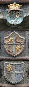
Blazon : "In silver a continuous red cross, in the first corner a six-pointed black star over a black crescent moon." |
| Crest Reason: The 1954 former town Kaisersesch from the Rhineland-Palatinate Ministry of the Interior awarded coat of arms is an old aldermen seal of kurtrierischen Office location Kaisersesch back from the 1502nd The cross refers to the Electorate of Trier and the symbols of the star and crescent, which are not infrequently represented in Rhenish seals, probably refer to a place of judgment, but perhaps also to a Marian patronage. |

Tower of St. Pancras

Pilgrims' fountain at the church, station on the Way of St. James

Depeschenreiterbrunnen

Postillon on the fountain column
Coat of arms on the fountain
.JPG)
.JPG)
.jpg)
.JPG)

Attractions
- Roman road embankment in the Langheck (so-called "Römerwall"), partly identical to a medieval Landwehr .
- The old stagecoach route via Landkern to Cochem is clearly recognizable in the area (south of the A 48, east of the L 98) and can be hiked.
- Catholic parish church of St. Pankratius from 1898 to 1900 (architect Lambert von Fisenne ) with the city's landmark, the leaning church tower from the 14th century.
- "Old prison" in the historic town center, former Kurtrierisches Amtshaus (Burgmannenhaus) with a medieval core, today a local museum.
- The Depeschenreiterbrunnen built in 2000 on the Alte Postplatz is a reminder of the time of the postillions , stagecoaches, dispatch riders and the Thurn-und-Taxis'sche post station from 1725 in Kaisersesch. On top of the fountain is a bronze sculpture of a rider with a golden post horn. Coats of arms are all around the fountain bowl as a sign of the city's history, including a royal crown reminiscent of Queen Rizecha , who first mentioned the place Esch in a deed of donation from 1051-1056, the court coat of arms, first mentioned in 1554, and the city coat of arms.
- At the station of the Way of St. James behind the church is the pilgrims' fountain, inaugurated in 2009 with a bronze sculpture. The figure represents a pilgrim who is resting, has taken off his shoes and is cooling his feet in the well water. It is the work of the Cologne-based sculptor Hans-Günther Obermaier (* 1943) from 2008.
See also: List of cultural monuments in Kaisersesch
traffic

Kaisersesch has a stop on the Eifelquerbahn . DB Regio regional trains run between Kaisersesch and Andernach , with connections in Andernach in the direction of Cologne and Koblenz .
In the summer months, rail buses and steam trains were offered on the Eifelquerbahn via Ulmen (Eifel) and Daun to Gerolstein for several years . There was a connection to regional trains on the Eifel route to Cologne and Trier .
Kaisersesch is located directly on the federal motorway 48 and is crossed by the state road L 98 Mayen - Cochem . The stagecoach route ran via Landkern to Cochem.
Personalities
- Werner Höfer (1913–1997), journalist and television presenter
- Peter Kremer (1901–1989), local writer
- Oswald Mathias Ungers (1926–2007), architect
Others
The Bundeswehr training area was abandoned in March 2013.
literature
- Margret Wensky: Cities and Freedoms up to 1500 (= Historical Atlas of the Rhineland . Volume VI.2 ). Bonn 2008, ISBN 978-3-7749-3562-4 , pp. 50-51 .
- Ursula Reuter: Jewish communities from the early 19th to the beginning of the 21st century (= Historical Atlas of the Rhineland . Volume VIII.8 ). Bonn 2007, ISBN 978-3-7749-3524-2 , pp. 53 .
- General Directorate for Cultural Heritage Rhineland-Palatinate (ed.): Informational directory of cultural monuments, Cochem-Zell district ( Cochem-Zell monuments directory, December 29, 2011), 2011.
- Cochem-Zell: Landscape on the Moselle (= guide to archaeological monuments in Germany. Volume 46./ Archeology on the Middle Rhine and Moselle. Volume 17.). Stuttgart 2005, ISBN 3-8062-1953-2 , pp. 121-125.
Web links
- Website of the city of Kaisersesch
- The history of the Jews in Kaisersesch ( Memento from June 28, 2003 in the Internet Archive )
- Literature about Kaisersesch in the Rhineland-Palatinate state bibliography
Individual evidence
- ↑ State Statistical Office of Rhineland-Palatinate - population status 2019, districts, communities, association communities ( help on this ).
- ↑ State Statistical Office Rhineland-Palatinate: My village, my city. Retrieved March 3, 2020 .
- ^ Heinrich Beyer, Leopold Eltester, Adam Goerz a. a .: Middle Rhine document book / document book on the history of the Middle Rhine territories now forming the Prussian administrative districts of Coblenz and Trier, Coblenz edition, 3 volumes 1860–1874. Volume 1, No. 335: “Emperor Heinrich III. confirms the donations made by Queen Richeza of Poland to the Brauweiler Abbey. 1051, July 18th. "And Volume 1, No. 343:" Queen Richeza of Poland describes the goods she donated to the Brauweiler Abbey. 1056. "
- ↑ Dieter Junker: Against the "WAAhnsinn": Nine months that moved the Eifel. In: Rhein-Zeitung. March 13, 2012, accessed July 14, 2017 .
- ^ Entry on Kaisersesch city fortifications in the " KuLaDig " database of the Rhineland Regional Council , accessed on July 14, 2017.
- ↑ State Main Archive Koblenz, 1A 3001
- ↑ Official municipality directory (= State Statistical Office of Rhineland-Palatinate [Hrsg.]: Statistical volumes . Volume 407 ). Bad Ems February 2016, p. 187 (PDF; 2.8 MB).
- ↑ Entry on the Kaisersesch synagogue (prayer house "Judenschule", today residential building) in the database " KuLaDig " of the Rhineland Regional Association , accessed on July 14, 2017.
- ^ The Regional Returning Officer Rhineland-Palatinate: Local elections 2019, city and municipal council elections.
- ↑ The city arms. Kaisersesch, accessed on March 3, 2020 .
- ↑ Cochem-Zell: Landscape on the Moselle. 2005, p. 121 ff.
- ↑ a b Hiking and Leisure Map Moselle Valley, ISBN 978-3-933671-16-5
- ↑ a b List of monuments in the Cochem-Zell district 2011, p. 27
- ↑ End of service Eifelquerbahn
- ↑ Information on the decision on the future need for site facilities of the Bundeswehr. Force Base, November 25, 2013, archived from original on October 4, 2013 ; Retrieved on November 15, 2017 (existing facilities).

Alf | Alflen | Altlay | Alt-trimmed | Auderath | Bad Bertrich | Beilstein | Beuren | Binningen | Blankenrath | Brachtendorf | Bremm | Briedel | Brieden | Briedern | Brohl | Bruttig-Fankel | Büchel | Bullay | Cochem | Dohr | Durfus | Düngenheim | Ediger-Eller | Ellenz-Poltersdorf | Eppenberg | Serious | Eulgem | Faid | Felt | Forst (Eifel) | Forst (Hunsrück) | Gamling | Gevenich | Gillenbeuren | Greimersburg | Grenderich | Hambuch | Haserich | Hauroth | Hesweiler | Illerich | Kaifenheim | Kail | Kaisersesch | Kalenborn | Kliding | Klotten | Country core | Laubach | Leienkaul | Lie | Liesenich | Lütz | Lutzerath | Masburg | Mesenich | Medium- bodied | Möntenich | Moritzheim | Mosel core | Tired (Moselle) | Müllenbach | Neef | Nehren | Panzweiler | Peterswald -öffelscheid | Pomerania | Pünderich | Reidenhausen | Roes | Sankt Aldegund | Showers | Schmitt | Senheim | Sosberg | Tellig | Treis cards | Elms | Urmersbach | Urschmitt | Valwig | Wagenhausen | Walhausen | Hamlet | Wirfus | Wollmerath | Zell (Mosel) | Zettingen