
Faid
| coat of arms | Germany map | |
|---|---|---|

|
Coordinates: 50 ° 9 ′ N , 7 ° 7 ′ E |
|
| Basic data | ||
| State : | Rhineland-Palatinate | |
| County : | Cochem cell | |
| Association municipality : | Cochem | |
| Height : | 413 m above sea level NHN | |
| Area : | 8.23 km 2 | |
| Residents: | 1033 (Dec. 31, 2019) | |
| Population density : | 126 inhabitants per km 2 | |
| Postal code : | 56814 | |
| Area code : | 02671 | |
| License plate : | COC, ZEL | |
| Community key : | 07 1 35 029 | |
| Association administration address: | Ravenéstrasse 61 56812 Cochem |
|
| Website : | ||
| Local Mayor : | Stefan Thomas | |
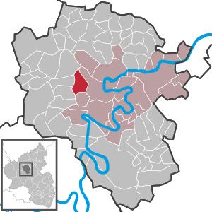
| Location of the local community Faid in the district of Cochem-Zell | ||
  |
||

Faid is a municipality in the Cochem-Zell district in Rhineland-Palatinate . It belongs to the Cochem community .
geography
Faid is located west of Cochem on the edge of the Eifel .
history
The village was first mentioned in 943 in a deed of donation to the Stablo monastery . Under the rule of Kurtrier , Faid and Cochem formed a community with shared forest ownership . The rule of Trier expired in 1794 with the occupation by the French revolutionary army . In 1815 the place was assigned to the Kingdom of Prussia at the Congress of Vienna , and even in Prussian times there were disputes between Faid and Cochem over joint ownership. Since 1946 it has been part of the then newly formed state of Rhineland-Palatinate .
Municipal council
The local council in Faid consists of 16 council members, who were elected in a personalized proportional representation in the local elections on May 26, 2019 , and the honorary local mayor as chairman.
traffic
Faid is on the B 259 and has bus connections to Cochem , Lutzerath and Ulmen .
See also
Web links
- Literature about Faid in the Rhineland-Palatinate State Bibliography
Individual evidence
- ↑ State Statistical Office of Rhineland-Palatinate - population status 2019, districts, communities, association communities ( help on this ).
- ^ The Regional Returning Officer Rhineland-Palatinate: Local elections 2019, city and municipal council elections

Alf | Alflen | Altlay | Alt-trimmed | Auderath | Bad Bertrich | Beilstein | Beuren | Binningen | Blankenrath | Brachtendorf | Bremm | Briedel | Brieden | Briedern | Brohl | Bruttig-Fankel | Büchel | Bullay | Cochem | Dohr | Durfus | Düngenheim | Ediger-Eller | Ellenz-Poltersdorf | Eppenberg | Serious | Eulgem | Faid | Felt | Forst (Eifel) | Forst (Hunsrück) | Gamling | Gevenich | Gillenbeuren | Greimersburg | Grenderich | Hambuch | Haserich | Hauroth | Hesweiler | Illerich | Kaifenheim | Kail | Kaisersesch | Kalenborn | Kliding | Klotten | Country core | Laubach | Leienkaul | Lie | Liesenich | Lütz | Lutzerath | Masburg | Mesenich | Medium- bodied | Möntenich | Moritzheim | Mosel core | Tired (Moselle) | Müllenbach | Neef | Nehren | Panzweiler | Peterswald -öffelscheid | Pomerania | Pünderich | Reidenhausen | Roes | Sankt Aldegund | Showers | Schmitt | Senheim | Sosberg | Tellig | Treis cards | Elms | Urmersbach | Urschmitt | Valwig | Wagenhausen | Walhausen | Hamlet | Wirfus | Wollmerath | Zell (Mosel) | Zettingen