
Wollmerath
| coat of arms | Germany map | |
|---|---|---|

|
Coordinates: 50 ° 9 ′ N , 6 ° 59 ′ E |
|
| Basic data | ||
| State : | Rhineland-Palatinate | |
| County : | Cochem cell | |
| Association municipality : | Elms | |
| Height : | 378 m above sea level NHN | |
| Area : | 4.06 km 2 | |
| Residents: | 206 (Dec. 31, 2019) | |
| Population density : | 51 inhabitants per km 2 | |
| Postal code : | 56826 | |
| Area code : | 02677 | |
| License plate : | COC, ZEL | |
| Community key : | 07 1 35 091 | |
| Association administration address: | Marktplatz 1 56766 Ulmen |
|
| Website : | ||
| Local Mayor : | Ulrich Laux | |
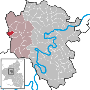
| Location of the local community Wollmerath in the district of Cochem-Zell | ||
  |
||


Wollmerath is a municipality in the Cochem-Zell district in Rhineland-Palatinate . It belongs to the Ulmen community .
geography
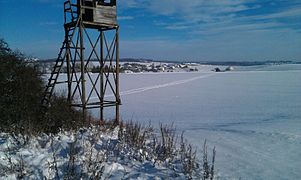
Wollmerath is located eleven kilometers southeast of the city of Daun in the foothills of a side valley of the Ueßbach . The village covers altitudes between 360 m above sea level. NHN and 410 m above sea level NHN . Geographically, can the agricultural half municipality in the Eastern Südwestsaum Hocheifel almost entirely the Middle Üßbachtal assign a section on the northwest border already the Ueßbachbergland . There the municipality reaches also with around 435 m above sea level. NHN its highest point on the ground , its lowest at 325 m above sea level. NHN at the southern exit of the Ueßbach from the district. The Birkenhof, Gillenbeurenermühle and Wollmerathermühle residential areas belong to Wollmerath.
Wollmerath borders (clockwise) on the local communities Filz , Schmitt , Gillenbeuren , Wagenhausen , Winkel (Eifel) and Demerath (both rural districts of Vulkaneifel).
history
Wollmerath was first mentioned in a document in 1193. From 1241 until the end of the 18th century, it was the eponymous capital of the "Herrschaft Wollmerath", which was inherited from the Counts of Wied and was under the sovereignty of Kurtrier . The last lords of domination belonged to v noble family of the Barons. Breiten-Landenberg . In addition to Wollmerath, the rulership also included the villages of Filz , Niederwinkel and Wagenhausen .
After the occupation of the Left Bank of the Rhine in 1794/96 by French revolutionary troops , the place became French, in 1815 the region and with it Wollmerath were assigned to the Kingdom of Prussia at the Congress of Vienna . Since 1946 the place has been part of the then newly formed state of Rhineland-Palatinate .
- Population development
The development of the population of Wollmerath, the values from 1871 to 1987 are based on censuses:
|
|
Municipal council
The council in Wollmerath consists of six council members, who in the local elections on May 26, 2019 in a majority vote were elected, and the honorary mayor as chairman.
Attractions
- Parish church of St. Maria Magdalena with the tombstones of Ernst Carl Anton Joseph Freiherr von Breiten-Landenberg and his wife Maria Magdalena, née Truchsess von Rheinfelden, as well as an organ built by Balthasar König in 1749.
- The Wollmerather Kopp is one of the young, Quaternary, volcanoes and consists of sweat slag, volcanic lapilli and ash deposits. Mining was carried out here until the 1960s, since then the Wollmerather Kopp has been out of sight. Like the Wollmerather Maar, the Wollmerather Kopp lies directly on the Siegen main thrust, a major geological fault zone that extends from Siegen to the Gillenfeld area.
- Wollmerather Kopp
Direction Wollmerath

Wollmerather Kopp
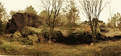
Front view of the upper head


- The Maare & Thermen path from Bad Bertrich to Ulmen, which runs through the Üßbachtal valley, has been extended through the village of Wollmerath with an approximately 1.5 kilometer long supplementary loop.
See also
Web links
- Website of the local community Wollmerath
- Local community Wollmerath on the website of the Verbandsgemeinde Ulmen
- Literature about Wollmerath in the Rhineland-Palatinate state bibliography
Individual evidence
- ↑ State Statistical Office of Rhineland-Palatinate - population status 2019, districts, communities, association communities ( help on this ).
- ↑ a b State Statistical Office Rhineland-Palatinate: Regional data.
- ↑ State Statistical Office Rhineland-Palatinate (ed.): Official directory of the municipalities and parts of the municipality. Status: January 2019 [ Version 2020 is available. ] . S. 36 (PDF; 3 MB).
- ^ Nikolaus Joseph Thome: The former high court Wollmerath . In: Heimatbuch des Kreises Cochem . Sesterhenn, Kaisersesch 1926, p. 142 ( dilibri.de ).
- ^ The Regional Returning Officer Rhineland-Palatinate: Local elections 2019, city and municipal council elections

Alf | Alflen | Altlay | Alt-trimmed | Auderath | Bad Bertrich | Beilstein | Beuren | Binningen | Blankenrath | Brachtendorf | Bremm | Briedel | Brieden | Briedern | Brohl | Bruttig-Fankel | Büchel | Bullay | Cochem | Dohr | Durfus | Düngenheim | Ediger-Eller | Ellenz-Poltersdorf | Eppenberg | Serious | Eulgem | Faid | Felt | Forst (Eifel) | Forst (Hunsrück) | Gamling | Gevenich | Gillenbeuren | Greimersburg | Grenderich | Hambuch | Haserich | Hauroth | Hesweiler | Illerich | Kaifenheim | Kail | Kaisersesch | Kalenborn | Kliding | Klotten | Country core | Laubach | Leienkaul | Lie | Liesenich | Lütz | Lutzerath | Masburg | Mesenich | Medium- bodied | Möntenich | Moritzheim | Mosel core | Tired (Moselle) | Müllenbach | Neef | Nehren | Panzweiler | Peterswald -öffelscheid | Pomerania | Pünderich | Reidenhausen | Roes | Sankt Aldegund | Showers | Schmitt | Senheim | Sosberg | Tellig | Treis cards | Elms | Urmersbach | Urschmitt | Valwig | Wagenhausen | Walhausen | Hamlet | Wirfus | Wollmerath | Zell (Mosel) | Zettingen