Peterswald -öffelscheid
| coat of arms | Germany map | |
|---|---|---|

|
Coordinates: 50 ° 0 ' N , 7 ° 17' E |
|
| Basic data | ||
| State : | Rhineland-Palatinate | |
| County : | Cochem cell | |
| Association municipality : | Zell (Moselle) | |
| Height : | 450 m above sea level NHN | |
| Area : | 15.33 km 2 | |
| Residents: | 728 (Dec. 31, 2019) | |
| Population density : | 47 inhabitants per km 2 | |
| Postal code : | 56858 | |
| Area code : | 06545 | |
| License plate : | COC, ZEL | |
| Community key : | 07 1 35 071 | |
| Community structure: | 2 districts | |
| Association administration address: | Corray 1 56856 Zell (Moselle) |
|
| Website : | ||
| Local Mayor : | Kurt Mähser | |
| Location of the community Peterswald -akenbofelscheid in the district of Cochem-Zell | ||
Peterswald -öffelscheid is a municipality in the district of Cochem-Zell in Rhineland-Palatinate . It belongs to the Verbandsgemeinde Zell (Mosel) .
geography
The two places Peterswald and Löffelscheid are approx. 8 km east-southeast of Zell an der Mosel in the Hunsrück . The Brühlhof residential area also belongs to the district of Löffelscheid .
Language dialect
Hunsrück is spoken in Peterswald .
history
First documented mention in 1233 as Silva s. Petri . Later also called Petrusdorf . Both belonged to the "triple territory". As in the Beltheim court , Kurtrier , Sponheim and Braunshorn (later Winneburg and Metternich) shared sovereignty. In 1790 the rule was Peterswald with the villages Peterswald and Löffelscheid the Counts of Metternich allocated. From 1794 the places were under French rule. In 1815 they were assigned to the Kingdom of Prussia at the Congress of Vienna . Since 1946 they have been part of the then newly formed state of Rhineland-Palatinate . On November 7, 1970, the two communities merged to form Peterswald -akenöffelscheid .
- Statistics on population development
The development of the number of inhabitants in relation to today's municipality of Peterswald-Löffelscheid; the values from 1871 to 1987 are based on censuses:
|
|
Municipal council
The local council in St-Löffelscheid consists of twelve council members, who in the local elections on May 26, 2019 in a majority vote were elected, and the honorary mayor as chairman.
Church in Spoonscheid
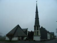
The festive inauguration of the new branch church in Löffelscheid “Maria Heimsuchung” took place on July 5, 1964. The patroness is the Mother of God (“Maria Heimsuche”), the second patron is Saint Nicholas. The church is a round building (two cones were pushed into one another). The architect was Bruno Schönhagen , Koblenz. The towering wall symbolizes with the old altarpiece (Holy Trinity), the Mother of God, the saints and Christ in the tabernacle. The smaller cone "carries" salvation - the Eucharist - the altar - the confessional chapel. The church ceiling encloses you like the protective cloak of Our Lady. The pews close in a semicircle around the altar. The altar is a simple table made of red sandstone. The bell tower is not attached to the church and is 28 meters high.
Church in Peterswald
The current church in Peterswald was built between 1765 and 1766. The church located in the middle of the village is a hall building with a separate choir. The former west gable was given today's front by a tower in 1923. Special features of the bell tower are the sound openings on all sides, a curved tip and a cross. The murals on the very old altar show three arrests of Jesus and the teaching of five disciples. An old bronze bell from 1463 is worth seeing. The church patrons are "Peter and Paul".
traffic
Peterswald -öffelscheid is connected to Blankenrath by the bus route 761 of the Rhein-Mosel transport association, and the VRM routes 321 and 669 also serve the place.
Hahn is only 5 km southwest of Peterswald -akenbofelscheid . The district of Löffelscheid is located in the noise protection area of Frankfurt-Hahn Airport and is therefore exposed to a certain level of noise pollution.
See also
Web links
- Literature about Peterswald-Löffelscheid in the Rhineland-Palatinate state bibliography
Individual evidence
- ↑ State Statistical Office of Rhineland-Palatinate - population status 2019, districts, communities, association communities ( help on this ).
- ↑ Official municipality directory (= State Statistical Office of Rhineland-Palatinate [Hrsg.]: Statistical volumes . Volume 407 ). Bad Ems February 2016, p. 175 (PDF; 2.8 MB).
- ↑ State Statistical Office Rhineland-Palatinate - regional data
- ^ The Regional Returning Officer Rhineland-Palatinate: Local elections 2019, city and municipal council elections


