
Zettingen
| coat of arms | Germany map | |
|---|---|---|

|
Coordinates: 50 ° 14 ' N , 7 ° 12' E |
|
| Basic data | ||
| State : | Rhineland-Palatinate | |
| County : | Cochem cell | |
| Association municipality : | Kaisersesch | |
| Height : | 378 m above sea level NHN | |
| Area : | 3.7 km 2 | |
| Residents: | 263 (Dec. 31, 2019) | |
| Population density : | 71 inhabitants per km 2 | |
| Postal code : | 56761 | |
| Area code : | 02653 | |
| License plate : | COC, ZEL | |
| Community key : | 07 1 35 093 | |
| Association administration address: | Am Römerturm 2 56759 Kaisersesch |
|
| Website : | ||
| Local Mayor : | Johannes Hammes | |
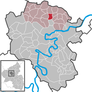
| Location of the local community Zettingen in the district of Cochem-Zell | ||
  |
||

Zettingen is a municipality in the Cochem-Zell district in Rhineland-Palatinate . It belongs to the Kaisersesch association.
geography
Zettingen is four kilometers east of the city of Kaisersesch, immediately south of the federal motorway 48 . The village extends over an area sloping from west to east to Brohlbach and includes altitudes between 360 m above sea level. NHN and 385 m above sea level NHN . A tributary of the Brohlbach rises with the Kerzbach to the south of the village . In terms of natural space , around three quarters of the agricultural and sparsely forested municipal area can be assigned to the Kaisersescher Eifelrand .
Zettingen borders (clockwise) on the local communities Gamlen , Kaifenheim , Brachtendorf , Durfus , Wirfus , Illerich and Hambuch .
history
The first documented mention of Zettingen comes from the year 1267. Archaeological finds in and around the place allow the conclusion that the area was already settled by the Romans.
In the 13th century that the archbishops of Trier , the Treasury Klotten bring its hinterland, was one of the well Zettingen, per se. On October 1, 1251, the Archbishop of Trier, Arnold II of Isenburg, incorporated the parish of Hambuch and the associated localities into the Cistercian convent of Rosenthal with the consent of the patron saint .
From 1350, the Mädburg Monastery in the Elztal near Kehrig also owned property in Zettingen.
In the 15th century, the Lords of Brohl owned a farm in Zettingen, which later fell to Georg von der Leyen and Dietrich von Braunsberg . The gentlemen von Brohl were also owners of the bailiwick, the hen and goose interest in Zettingen. The collegiate monastery at Karden also owned meadows, arable land and wilderness in Zettingen. After the secularization of the spiritual goods, they were auctioned by the French between 1804 and 1808. This also affected the property of the monastery Rosental near Binningen , which had four hectares of arable land, three hectares of wilderness and one hectare of meadows in Zettingen.
Until the end of the 18th century, Zettingen belonged to the rulers of Kurtrier and was assigned to the high court of Klotten in the office of Cochem . In the Trier fire book from 1563 there were ten fireplaces (households) in Zettingen, in 1684 there were only seven.
In 1794 French revolutionary troops annexed the Left Bank of the Rhine ; from 1798 to 1814 Zettingen belonged to the canton Kaisersesch in the Koblenz arrondissement of the Rhine-Moselle department . The municipal council (Zettinger community representative in the Mairie Kaisersesch) was the citizen of Steffes in 1808.
Due to the resolutions at the Congress of Vienna (1815), the region was assigned to the Kingdom of Prussia . Under the Prussian administration, the community of Zettingen came to the mayor's office of Kaisersesch in the district of Cochem , which belonged to the new administrative district of Koblenz and from 1822 to the Rhine province .
The municipality of Zettingen has been part of the state of Rhineland-Palatinate since 1946 , has belonged to the Kaisersesch association since 1968 and to the Cochem-Zell district since 1969 .
- Statistics on population development
The development of the population of Zettingen, the values from 1871 to 1987 are based on censuses:
|
|
politics
Municipal council
The council in Zettingen consists of six council members, who in the local elections on May 26, 2019 in a majority vote were elected, and the honorary mayor as chairman.
Local mayor
Johannes Hammes has been the local mayor since August 2011. His predecessor was Hans-Josef Schaden, who resigned from office on April 30, 2011 after 32 years in office for personal reasons. Damage was the senior mayor of the Kaisersesch community and the Cochem-Zell district.
Public facilities
The Zettingen community has been running a 3-group kindergarten in Kaifenheim with the neighboring communities of Brachtendorf, Gamlen and Kaifenheim since 1982, which was expanded in 2003 to include a group and a multi-purpose room.
Born in Zettingen
- Marie-Theres Hammes-Rosenstein (1954–2019), Mayor of the City of Koblenz
See also
Web links
- Internet presence of the local community Zettingen
- Local community Zettingen on the website of the association community Kaisersesch
- Literature about Zettingen in the Rhineland-Palatinate state bibliography
Individual evidence
- ↑ State Statistical Office of Rhineland-Palatinate - population status 2019, districts, communities, association communities ( help on this ).
- ↑ a b State Statistical Office Rhineland-Palatinate - regional data
- ^ Johann Friedrich Schannat, Johann Peter Bachem: Eiflia illustrata or geographical and historical description of the Eifel , Volume 3, 1852, p. 279 ( Google Books )
- ^ Wilhelm Fabricius : Explanations of the historical atlas of the Rhine Province, Volume 2: The map of 1789. Bonn 1898, pp. 117, 146.
- ↑ Handbook for the residents of the Rhine-Mosel Department , Koblenz: Prefecture-Buchdruckerey, 1808, p. 64. ( www.dilibri.de )
- ↑ Topographical-statistical overview of the government district of Coblenz , Coblenz: Hölscher, 1843, p. 39 ( www.dilibri.de )
- ^ The Regional Returning Officer Rhineland-Palatinate: Municipal elections 2014 city and municipal council elections

Alf | Alflen | Altlay | Alt-trimmed | Auderath | Bad Bertrich | Beilstein | Beuren | Binningen | Blankenrath | Brachtendorf | Bremm | Briedel | Brieden | Briedern | Brohl | Bruttig-Fankel | Büchel | Bullay | Cochem | Dohr | Durfus | Düngenheim | Ediger-Eller | Ellenz-Poltersdorf | Eppenberg | Serious | Eulgem | Faid | Felt | Forst (Eifel) | Forst (Hunsrück) | Gamling | Gevenich | Gillenbeuren | Greimersburg | Grenderich | Hambuch | Haserich | Hauroth | Hesweiler | Illerich | Kaifenheim | Kail | Kaisersesch | Kalenborn | Kliding | Klotten | Country core | Laubach | Leienkaul | Lie | Liesenich | Lütz | Lutzerath | Masburg | Mesenich | Medium- bodied | Möntenich | Moritzheim | Mosel core | Tired (Moselle) | Müllenbach | Neef | Nehren | Panzweiler | Peterswald -öffelscheid | Pomerania | Pünderich | Reidenhausen | Roes | Sankt Aldegund | Showers | Schmitt | Senheim | Sosberg | Tellig | Treis cards | Elms | Urmersbach | Urschmitt | Valwig | Wagenhausen | Walhausen | Hamlet | Wirfus | Wollmerath | Zell (Mosel) | Zettingen