Lütz
| coat of arms | Germany map | |
|---|---|---|

|
Coordinates: 50 ° 10 ′ N , 7 ° 22 ′ E |
|
| Basic data | ||
| State : | Rhineland-Palatinate | |
| County : | Cochem cell | |
| Association municipality : | Cochem | |
| Height : | 140 m above sea level NHN | |
| Area : | 5.48 km 2 | |
| Residents: | 271 (Dec. 31, 2019) | |
| Population density : | 49 inhabitants per km 2 | |
| Postal code : | 56290 | |
| Area code : | 02672 | |
| License plate : | COC, ZEL | |
| Community key : | 07 1 35 056 | |
| Association administration address: | Ravenéstrasse 61 56812 Cochem |
|
| Website : | ||
| Mayoress : | Simone Nick | |
| Location of the local community Lütz in the district of Cochem-Zell | ||
Lütz is a municipality in the Cochem-Zell district in Rhineland-Palatinate . It has been a member of the Cochem community since July 1, 2014 . Lütz is a state-approved resort .
geography
The place is located in the northern Hunsrück in a side valley of the Moselle (between the Moselle towns of Burgen and Treis-Karden) only a few kilometers from the Moselle. Lütz is located in the Lützbachtal , which is hardly accessible to traffic. The village is characterized by a number of beautiful half-timbered houses.
history
Lütz was first mentioned in a document in 912, when King Karl III. gave his property to "Lutiaco" to the monastery of St. Maximin .
Ecclesiastically, the parish of Lütz belonged to the land chapter of Zell of the Archdiocese of Trier , but did not belong to the territory of the Electorate of Trier . The church was first mentioned around 1250 under the name Luzze in the property register of the Archbishop of Trier. According to a visitation report from 1569, the parish “Lutz” included the branches “Dommershusen” ( Dommershausen ) with “Ibeshusen” Eveshausen , “Budershusen” (Petershausen), “Lych” ( Lieg ), “Lair” ( Lahr ) and “Sultzhusen” “( Zilshausen ). In 1806 Dommershausen and Eveshausen became an independent parish, and in 1869 the Lieg parish was spun off.
A village fire destroyed parts of the village in 1749. The church of St. Maximinus (with the exception of the Romanesque tower from the 12th century) and the town hall had to be rebuilt.
In the 14th century Lütz belonged to the Eltz rule . Lütz was owned by imperial knights and belonged to Baron von Wiltberg when the French revolutionary troops took the left bank of the Rhine in 1794 . In 1815 the place was assigned to the Kingdom of Prussia at the Congress of Vienna . Since 1946 the place has been part of the then newly formed state of Rhineland-Palatinate .
politics
Municipal council
The municipal council in Lütz consists of eight council members, who were elected by a majority vote in the local elections on May 26, 2019 , and the honorary local mayor as chairman.
coat of arms
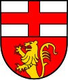
| Blazon : "In the divided shield, above in silver a red bar cross, below in red a black armored and tongued growing golden lion." | |
.
Culture and sights
The Hunsrück-Moselle cycle path runs through the village. A hiking trail runs parallel to the stream through the valley. A newly created slate mine path near Lütz provides knowledge about the slate mining that was formerly operated in the Lützbachtal. Until 1953, slate was mined in what were formerly eleven pits with 19 tunnels and 5 test tunnels. The slate heaps today offer rare animal and plant species a unique biotope.
tourism
Ship landing stage Moselle
The closest ship landing stage for Lütz is in Treis-Karden OT Treis.
literature
- Daniel Kugel: Lütz and his story. Lütz 2012.
Web links
- Internet presence of the community of Lütz
- Internet presence of the parish of Lütz
- Coincidental find: vagabond and "strangers" in the parish of Lütz / Rhineland-Palatinate
- Literature about Lütz in the Rhineland-Palatinate state bibliography
Individual evidence
- ↑ State Statistical Office of Rhineland-Palatinate - population status 2019, districts, communities, association communities ( help on this ).
- ↑ State Statistical Office Rhineland-Palatinate - regional data
- ^ Philipp de Lorenzi: Contributions to the history of all parishes in the Diocese of Trier , Bischöfliches General-Vicariate, 1887, p. 183
- ^ The Regional Returning Officer Rhineland-Palatinate: Local elections 2019, city and municipal council elections.


