
Kail
| coat of arms | Germany map | |
|---|---|---|

|
Coordinates: 50 ° 11 ′ N , 7 ° 15 ′ E |
|
| Basic data | ||
| State : | Rhineland-Palatinate | |
| County : | Cochem cell | |
| Association municipality : | Kaisersesch | |
| Height : | 294 m above sea level NHN | |
| Area : | 6.15 km 2 | |
| Residents: | 300 (Dec. 31, 2019) | |
| Population density : | 49 inhabitants per km 2 | |
| Postal code : | 56829 | |
| Area code : | 02672 | |
| License plate : | COC, ZEL | |
| Community key : | 07 1 35 044 | |
| LOCODE : | DE KA3 | |
| Association administration address: | Am Römerturm 2 56759 Kaisersesch |
|
| Website : | ||
| Mayoress : | Barbara Gehle | |
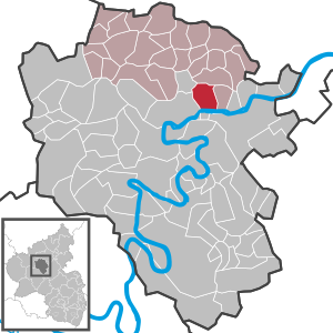
| Location of the local community Kail in the district of Cochem-Zell | ||
  |
||

Kail is a municipality in the Cochem-Zell district in Rhineland-Palatinate . It has been a member of the Kaisersesch community since July 1, 2014 .

Geographical location
The Moselle valley in the south, Pommerbachtal and Fellerbachtal in the east and west as well as the Kailer Hochwald in the north-west border the historical high plateau, which has been inhabited since the Stone Age.
climate
The annual precipitation is 642 mm. The precipitation is in the lower third of the values recorded in Germany. Lower values are registered at 29% of the measuring stations of the German Weather Service . The driest month is February, with the most rainfall in June. In June there is 1.6 times more rainfall than in February. Precipitation hardly varies and is evenly distributed over the year. Lower seasonal fluctuations are recorded at only 15% of the measuring stations .
history
The largest landowner in the area was from 1121 to 1806 the St. Kastor monastery in Karden . From 1794 Kail was under French rule, in 1815 the place was assigned to the Kingdom of Prussia at the Congress of Vienna . Since 1946 it has been part of the then newly formed state of Rhineland-Palatinate .
Municipal council
The council in Kail consists of six council members, who in the local elections on May 26, 2019 in a majority vote were elected, and the volunteer local mayor as chairman. Before 2014, the council had eight council members.
Culture and sights

The symbol of the village is the Catholic parish church of St. Bartholomew. It was built from 1901 to 1903 and is decorated with beautiful stained glass of the church windows in bright colors.
See also: List of cultural monuments in Kail
Economy and Infrastructure
The Kail community is dominated by agriculture , even if its economic importance has declined in recent decades. A majority of the population is now employed in other industries. There are fewer than ten full-time farms. Due to the high altitude of Kail, the place is flood-free. This was the reason for the Hubertus Vallendar distillery to relocate its headquarters from Pomerania to Kail after the flood of the century in 1997 . Kail does not have a local rail connection. The closest stop is Pommern (Mosel) on the Moselle route .
Web links
- Website of the parish of Kail
- Internet presence of the Vikariekirche Kail
- Literature about Kail in the Rhineland-Palatinate State Bibliography
Individual evidence
- ↑ State Statistical Office of Rhineland-Palatinate - population status 2019, districts, communities, association communities ( help on this ).
- ^ The Regional Returning Officer Rhineland-Palatinate: Local elections 2019, city and municipal council elections.

Alf | Alflen | Altlay | Alt-trimmed | Auderath | Bad Bertrich | Beilstein | Beuren | Binningen | Blankenrath | Brachtendorf | Bremm | Briedel | Brieden | Briedern | Brohl | Bruttig-Fankel | Büchel | Bullay | Cochem | Dohr | Durfus | Düngenheim | Ediger-Eller | Ellenz-Poltersdorf | Eppenberg | Serious | Eulgem | Faid | Felt | Forst (Eifel) | Forst (Hunsrück) | Gamling | Gevenich | Gillenbeuren | Greimersburg | Grenderich | Hambuch | Haserich | Hauroth | Hesweiler | Illerich | Kaifenheim | Kail | Kaisersesch | Kalenborn | Kliding | Klotten | Country core | Laubach | Leienkaul | Lie | Liesenich | Lütz | Lutzerath | Masburg | Mesenich | Medium- bodied | Möntenich | Moritzheim | Mosel core | Tired (Moselle) | Müllenbach | Neef | Nehren | Panzweiler | Peterswald -öffelscheid | Pomerania | Pünderich | Reidenhausen | Roes | Sankt Aldegund | Showers | Schmitt | Senheim | Sosberg | Tellig | Treis cards | Elms | Urmersbach | Urschmitt | Valwig | Wagenhausen | Walhausen | Hamlet | Wirfus | Wollmerath | Zell (Mosel) | Zettingen