
Bullay
| coat of arms | Germany map | |
|---|---|---|

|
Coordinates: 50 ° 3 ' N , 7 ° 8' E |
|
| Basic data | ||
| State : | Rhineland-Palatinate | |
| County : | Cochem cell | |
| Association municipality : | Zell (Moselle) | |
| Height : | 250 m above sea level NHN | |
| Area : | 3.97 km 2 | |
| Residents: | 1571 (Dec. 31, 2019) | |
| Population density : | 396 inhabitants per km 2 | |
| Postal code : | 56859 | |
| Area code : | 06542 | |
| License plate : | COC, ZEL | |
| Community key : | 07 1 35 019 | |
| Address of the municipal administration: |
Graf-Beisel-Str. 4 56859 Bullay |
|
| Website : | ||
| Local Mayor : | Matthias Müller | |
| Location of the local community Bullay in the district of Cochem-Zell | ||
  |
||


Bullay is a municipality in the Cochem-Zell district in the center of Rhineland-Palatinate . It belongs to the Verbandsgemeinde Zell (Mosel) and is located across from Alf on the Moselle .
geography
The local community Bullay is located in the middle of the federal state Rhineland-Palatinate.
history
It is certain that there was a Roman settlement in the area of the municipality. The first written mention as Buley infra Cell comes from the year 1150. From 1470 to 1550 there were mining operations in Bullay. Bullay was ruled by four barons: Zand von Merl, Boos von Waldeck, von Metzenhausen and von Kellenbach (later von Landenberg). From 1794 Bullay was under French rule and from 1798 to 1814 belonged to the canton of Zell in the Rhine-Moselle department . In 1815 the place was assigned to the Kingdom of Prussia at the Congress of Vienna . The Linke Moselle Valley Railway was built in 1879 . Since 1946 it has been part of the then newly formed state of Rhineland-Palatinate .
In 1993 there was the largest flood in the region to date, known as the “Christmas flood” or “century flood”.
- Statistics on population development
The development of the population of Bullay, the values from 1871 to 1987 are based on censuses:
|
|
politics
Municipal council
The local council in Bullay consists of 16 council members, who were elected in a personalized proportional representation in the local elections on May 26, 2019 , and the honorary local mayor as chairman.
The distribution of seats in the municipal council:
| choice | SPD | CDU | FWG | total |
|---|---|---|---|---|
| 2019 | 3 | 5 | 8th | 16 seats |
| 2014 | 3 | 6th | 7th | 16 seats |
| 2009 | 2 | 6th | 8th | 16 seats |
| 2004 | 2 | 7th | 7th | 16 seats |
FWG = Free Voters Group Bullay eV
Culture and sights
Buildings
See also: List of Cultural Monuments in Bullay
- Alf-Bullay double-decker bridge over the Moselle with the Moselle railway above the road
- The environmental station, which has received an architecture award from the state of Rhineland-Palatinate
- Bullay has also had a small mosque on the banks of the Moselle near the Alf-Bullay double-decker bridge since 2014
religion
As the only community in the predominantly Catholic district of Cochem-Zell , Bullay has had its own Sunni mosque since March 14, 2014. Since then, all 5 prayers of the day have been offered here for citizens of Sunni faith . The mosque belongs to the DiTiB association. Most of the members of the community have Turkish or German roots.
Picture gallery

View of Bullay and the Alf - Bullay double-decker bridge around 1880

The Moselle at Bullay
"Environmental Station" Bullay (DB)

Aerial view of Bullay from 1945


Economy and Infrastructure
traffic
Road traffic
Bullay is connected to the left bank of the Moselle via a double-decker bridge and thus to federal highways 49 (towards Koblenz) and 53 (towards Trier).
Rail transport
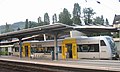
The train runs from the train station into the Prinzenkopf tunnel . The Bullay (DB) station is located on the Linke Moselle Valley Railway, Trier Hbf - Koblenz Hbf, which was completed in 1879. From 1905 until part of the route was closed in 1961, the Bullay Süd station was the northern terminus of the Moselle Railway Trier Nord - Bullay Süd, which was dismantled from 1961 and replaced by buses.
Waterways
A passenger ferry connects Bullay with Alf.
A community-owned jetty is available to recreational boaters for overnight stays free of charge.
Personalities
Sons and daughters of the church
- Marcus Braun (* 1971), writer
Web links
- Bullay local church website
- Literature about Bullay in the Rhineland-Palatinate State Bibliography
Individual evidence
- ↑ State Statistical Office of Rhineland-Palatinate - population status 2019, districts, communities, association communities ( help on this ).
- ↑ State Statistical Office Rhineland-Palatinate - regional data
- ^ The Regional Returning Officer Rhineland-Palatinate: Local elections 2019, city and municipal council elections

Alf | Alflen | Altlay | Alt-trimmed | Auderath | Bad Bertrich | Beilstein | Beuren | Binningen | Blankenrath | Brachtendorf | Bremm | Briedel | Brieden | Briedern | Brohl | Bruttig-Fankel | Büchel | Bullay | Cochem | Dohr | Durfus | Düngenheim | Ediger-Eller | Ellenz-Poltersdorf | Eppenberg | Serious | Eulgem | Faid | Felt | Forst (Eifel) | Forst (Hunsrück) | Gamling | Gevenich | Gillenbeuren | Greimersburg | Grenderich | Hambuch | Haserich | Hauroth | Hesweiler | Illerich | Kaifenheim | Kail | Kaisersesch | Kalenborn | Kliding | Klotten | Country core | Laubach | Leienkaul | Lie | Liesenich | Lütz | Lutzerath | Masburg | Mesenich | Medium- bodied | Möntenich | Moritzheim | Mosel core | Tired (Moselle) | Müllenbach | Neef | Nehren | Panzweiler | Peterswald -öffelscheid | Pomerania | Pünderich | Reidenhausen | Roes | Sankt Aldegund | Showers | Schmitt | Senheim | Sosberg | Tellig | Treis cards | Elms | Urmersbach | Urschmitt | Valwig | Wagenhausen | Walhausen | Hamlet | Wirfus | Wollmerath | Zell (Mosel) | Zettingen