
Valwig
| coat of arms | Germany map | |
|---|---|---|

|
Coordinates: 50 ° 9 ' N , 7 ° 13' E |
|
| Basic data | ||
| State : | Rhineland-Palatinate | |
| County : | Cochem cell | |
| Association municipality : | Cochem | |
| Height : | 90 m above sea level NHN | |
| Area : | 5.7 km 2 | |
| Residents: | 433 (Dec. 31, 2019) | |
| Population density : | 76 inhabitants per km 2 | |
| Postal code : | 56812 | |
| Area code : | 02671 | |
| License plate : | COC, ZEL | |
| Community key : | 07 1 35 086 | |
| Community structure: | 2 districts | |
| Association administration address: | Ravenéstrasse 61 56812 Cochem |
|
| Website : | ||
| Mayoress : | Angela Balensiefen | |
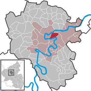
| Location of the local community Valwig in the district of Cochem-Zell | ||
  |
||


Valwig is a wine village on the Moselle in the Cochem-Zell district in Rhineland-Palatinate . The local community belongs to the Cochem Association .
geography
Geographical location
The place is on the right bank of the Moselle (river kilometer 55). The district town of Cochem is about three kilometers away.
geology
The Moselle valley belongs to the Rhenish Slate Mountains and is characterized by steep and rugged mountain slopes.
Community structure
The municipality of Valwig is divided into the following districts (with height information):
- Valwig ( 90 m above sea level )
- Valwigerberg ( 315 m above sea level )
Neighboring communities
The district Valwig borders on the Moselle downstream on Cochem, upstream on Bruttig-Fankel and is separated from Ernst by the Moselle . The municipality of Treis-Karden can be reached via the Valwigerberg .
history
In the first documents Valwig is mentioned as "Falavoia" "(866 AD)," Falaveia "(893 AD) and" Valefayer "(1130 AD). However, it is assumed that Valwig was already inhabited by Celts and Romans . This is supported by the Celto-Romanic name “Balbiacum”, which translates as “settlement of Balbius.” Valwig is therefore one of the oldest Moselle villages. With the occupation of the left bank of the Rhine in 1794 by French revolutionary troops , centuries of rule ended Kurtriers . The place was assigned to the Kingdom of Prussia at the Congress of Vienna in 1815. Since 1946 the place has been part of the then newly formed state of Rhineland-Palatinate .
Municipal council
The municipal council in Valwig consists of eight council members, who were elected by a majority vote in the local elections on May 26, 2019 , and the honorary local mayor as chairman.
Culture and sights

Parish Church of St. Martin
The parish church, built by Johann Claudius von Lassaulx between 1823 and 1827 and enthroned over the Valwig district, is the first neo-Romanesque church in Germany.
Pilgrimage Church of St. Mary and Magdalena
The construction of the small pilgrimage chapel on the Valwigerberg goes back to the middle of the 15th century. After the accumulation of reports of answers to prayer, it was built by the knight Johann von Winneburg to honor the “miraculous image of our dear Lady from the Mountains”.
Hiking trails
Two regional hiking trails run between the vineyards of Valwig, Cond and Bruttig-Fankel, where mainly Riesling is grown. The 7.5 km long Apolloweg Valwig , named after the Moselle Apollofalter , runs in the direction of Cochem and Valwigerberg . The Apolloweg, the first themed trail on the Moselle, was created by the municipality of Valwig with funds from the European Union's LEADER II program .
Since 2007 the 3.9 km long Breva-Weg (also Herrenbergsteig) has been leading up the Moselle to the Valwigerberg district and the neighboring municipality of Bruttig-Fankel. This is a joint project of the wine villages Bruttig, Ernst and Valwig, from whose name components the name of the path is derived. 17 winegrowers belong to the Breva interest group and together produce Breva wine from Riesling grapes from the steep slopes .
The Moselle cycle path is located directly on the banks of the Moselle in the direction of Cochem and Beilstein . Two supraregional hiking trails lead through the district of Valwig, the Moselsteig and the Moselhöhenweg .
Personalities
Born in Valwig
- Friedrich Bopparder (* around 1460–1519), vicar, scholaster and monastery dean in the collegiate monastery St. Castor (card).
- Peter Bopparder (around 1470 - around 1538), canon and dean of the collegiate monastery St. Castor (Karden)
- Martin Gobelius (around 1535–1598), monastery dean in Salmünster
- Franz Goebel (1881–1973), Capuchin, spiritual and theologian
Web links
- Numbers, data, facts for the districts of Valwig and Valwigerberg
- Tourist info municipality Valwig at valwig.de
- Apolloweg Valwig
- Valwiger Heimat-Gazette 2000
- Literature about Valwig in the Rhineland-Palatinate State Bibliography
Individual evidence
- ↑ State Statistical Office of Rhineland-Palatinate - population status 2019, districts, communities, association communities ( help on this ).
- ^ The Regional Returning Officer Rhineland-Palatinate: Local elections 2019, city and municipal council elections.

Alf | Alflen | Altlay | Alt-trimmed | Auderath | Bad Bertrich | Beilstein | Beuren | Binningen | Blankenrath | Brachtendorf | Bremm | Briedel | Brieden | Briedern | Brohl | Bruttig-Fankel | Büchel | Bullay | Cochem | Dohr | Durfus | Düngenheim | Ediger-Eller | Ellenz-Poltersdorf | Eppenberg | Serious | Eulgem | Faid | Felt | Forst (Eifel) | Forst (Hunsrück) | Gamling | Gevenich | Gillenbeuren | Greimersburg | Grenderich | Hambuch | Haserich | Hauroth | Hesweiler | Illerich | Kaifenheim | Kail | Kaisersesch | Kalenborn | Kliding | Klotten | Country core | Laubach | Leienkaul | Lie | Liesenich | Lütz | Lutzerath | Masburg | Mesenich | Medium- bodied | Möntenich | Moritzheim | Mosel core | Tired (Moselle) | Müllenbach | Neef | Nehren | Panzweiler | Peterswald -öffelscheid | Pomerania | Pünderich | Reidenhausen | Roes | Sankt Aldegund | Showers | Schmitt | Senheim | Sosberg | Tellig | Treis cards | Elms | Urmersbach | Urschmitt | Valwig | Wagenhausen | Walhausen | Hamlet | Wirfus | Wollmerath | Zell (Mosel) | Zettingen