
Moritzheim
| coat of arms | Germany map | |
|---|---|---|

|
Coordinates: 50 ° 3 ' N , 7 ° 16' E |
|
| Basic data | ||
| State : | Rhineland-Palatinate | |
| County : | Cochem cell | |
| Association municipality : | Zell (Moselle) | |
| Height : | 415 m above sea level NHN | |
| Area : | 4.02 km 2 | |
| Residents: | 128 (Dec. 31, 2019) | |
| Population density : | 32 inhabitants per km 2 | |
| Postal code : | 56865 | |
| Area code : | 06545 | |
| License plate : | COC, ZEL | |
| Community key : | 07 1 35 064 | |
| Association administration address: | Corray 1 56856 Zell (Moselle) |
|
| Website : | ||
| Local Mayor : | Adelbert Reis | |
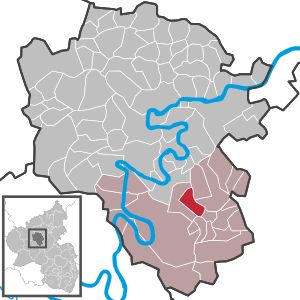
| Location of the Moritzheim community in the Cochem-Zell district | ||
  |
||

Moritzheim is a municipality in the Cochem-Zell district in Rhineland-Palatinate . It belongs to the Verbandsgemeinde Zell (Mosel) .
Geographical location
The place is in the Hunsrück at an altitude of about 415 m above sea level. NHN . The distance to the Moselle is approx. 12 km. It can be reached via the state road 98 to Senheim or the nearby federal road 421 to Zell. Parallel to the L 98, the place can also be hiked from Senheim on a partial stage of the Keltenweg Nahe – Mosel .
history
After a major fire in Senheim on August 13, 1839, 30 families who had become homeless founded the "Colony Hoch-Senheim". Soon after completion, the place was renamed Moritzheim after the Prussian district administrator of the Zell district , Friedrich Alexander Moritz . What is remarkable about this development is the regular checkerboard pattern of the place.
23 families emigrated to America in the years of need , 1846–1852. Only five residents stayed in the village at that time.
Moritzheim has been part of the then newly formed state of Rhineland-Palatinate since 1946 . By the 8th Administrative Simplification Act of July 28, 1970 with effect from November 7, 1970, the place came from the Verbandsgemeinde Senheim to the Verbandsgemeinde Zell (Mosel) in the Cochem-Zell district.
- Statistics on population development
The development of the population of Moritzheim, the values from 1871 to 1987 are based on censuses:
|
|
Municipal council
The municipal council in Moritzheim consists of six council members, who were elected by a majority vote in the local elections on May 26, 2019 , and the honorary local mayor as chairman.
Public facilities
Web links
- Hunsrück Reise: Moritzheim ( Memento from March 5, 2012 in the Internet Archive )
- Literature about Moritzheim in the Rhineland-Palatinate State Bibliography
Individual evidence
- ↑ State Statistical Office of Rhineland-Palatinate - population status 2019, districts, communities, association communities ( help on this ).
- ↑ State Statistical Office Rhineland-Palatinate - regional data
- ^ The Regional Returning Officer Rhineland-Palatinate: Local elections 2019, city and municipal council elections

Alf | Alflen | Altlay | Alt-trimmed | Auderath | Bad Bertrich | Beilstein | Beuren | Binningen | Blankenrath | Brachtendorf | Bremm | Briedel | Brieden | Briedern | Brohl | Bruttig-Fankel | Büchel | Bullay | Cochem | Dohr | Durfus | Düngenheim | Ediger-Eller | Ellenz-Poltersdorf | Eppenberg | Serious | Eulgem | Faid | Felt | Forst (Eifel) | Forst (Hunsrück) | Gamling | Gevenich | Gillenbeuren | Greimersburg | Grenderich | Hambuch | Haserich | Hauroth | Hesweiler | Illerich | Kaifenheim | Kail | Kaisersesch | Kalenborn | Kliding | Klotten | Country core | Laubach | Leienkaul | Lie | Liesenich | Lütz | Lutzerath | Masburg | Mesenich | Medium- bodied | Möntenich | Moritzheim | Mosel core | Tired (Moselle) | Müllenbach | Neef | Nehren | Panzweiler | Peterswald -öffelscheid | Pomerania | Pünderich | Reidenhausen | Roes | Sankt Aldegund | Showers | Schmitt | Senheim | Sosberg | Tellig | Treis cards | Elms | Urmersbach | Urschmitt | Valwig | Wagenhausen | Walhausen | Hamlet | Wirfus | Wollmerath | Zell (Mosel) | Zettingen