
Hesweiler
| coat of arms | Germany map | |
|---|---|---|

|
Coordinates: 50 ° 3 ' N , 7 ° 17' E |
|
| Basic data | ||
| State : | Rhineland-Palatinate | |
| County : | Cochem cell | |
| Association municipality : | Zell (Moselle) | |
| Height : | 390 m above sea level NHN | |
| Area : | 2.31 km 2 | |
| Residents: | 122 (Dec. 31, 2019) | |
| Population density : | 53 inhabitants per km 2 | |
| Postal code : | 56865 | |
| Area code : | 06545 | |
| License plate : | COC, ZEL | |
| Community key : | 07 1 35 041 | |
| Association administration address: | Corray 1 56856 Zell (Moselle) |
|
| Website : | ||
| Local Mayor : | Manfred Wilhelms | |
| Location of the local community of Hesweiler in the Cochem-Zell district | ||
  |
||

Hesweiler is a municipality in the Cochem-Zell district in Rhineland-Palatinate . It belongs to the Verbandsgemeinde Zell (Mosel) .
geography
Hesweiler is located in the northern part of the Hunsrück near the B 421 and Blankenrath .
history
The place was first mentioned in a document in 1259. The Counts of Sponheim had jurisdiction until 1788 in the “Hasericher care”. From 1794, Hesweiler was under French rule and from 1798 to 1814 belonged to the canton of Zell in the Rhine-Mosel department . In 1815 the place was assigned to the Kingdom of Prussia at the Congress of Vienna . In 1848 the local chapel was built in honor of St. Joseph by the building contractor Binzen from Zell. Since 1946 the place has been part of the then newly formed state of Rhineland-Palatinate . Through the 8th Administrative Simplification Act of July 18, 1970, with effect from November 7, 1970, the community came from the Senheim community to the Zell (Mosel) community .
- Statistics on population development
The development of the population of Hesweiler, the values from 1871 to 1987 are based on censuses:
|
|
Municipal council
The municipal council in Hesweiler consists of six council members, who were elected by a majority vote in the local elections on May 26, 2019 , and the honorary local mayor as chairman.
traffic
Hesweiler is in the area of the Rhein-Mosel transport association . The bus line 722 offers daily connections to the next town, Zell (Mosel) , and to the next train station, Bullay (DB) on the Moselle route Koblenz - Trier .
See also
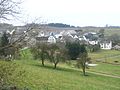
Hesweiler from the east
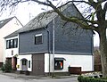
Town house in the village center

Hesweiler Chapel


Web links
- Literature about Hesweiler in the Rhineland-Palatinate state bibliography
Individual evidence
- ↑ State Statistical Office of Rhineland-Palatinate - population status 2019, districts, communities, association communities ( help on this ).
- ↑ State Statistical Office Rhineland-Palatinate - regional data
- ^ The Regional Returning Officer Rhineland-Palatinate: Local elections 2019, city and municipal council elections

Alf | Alflen | Altlay | Alt-trimmed | Auderath | Bad Bertrich | Beilstein | Beuren | Binningen | Blankenrath | Brachtendorf | Bremm | Briedel | Brieden | Briedern | Brohl | Bruttig-Fankel | Büchel | Bullay | Cochem | Dohr | Durfus | Düngenheim | Ediger-Eller | Ellenz-Poltersdorf | Eppenberg | Serious | Eulgem | Faid | Felt | Forst (Eifel) | Forst (Hunsrück) | Gamling | Gevenich | Gillenbeuren | Greimersburg | Grenderich | Hambuch | Haserich | Hauroth | Hesweiler | Illerich | Kaifenheim | Kail | Kaisersesch | Kalenborn | Kliding | Klotten | Country core | Laubach | Leienkaul | Lie | Liesenich | Lütz | Lutzerath | Masburg | Mesenich | Medium- bodied | Möntenich | Moritzheim | Mosel core | Tired (Moselle) | Müllenbach | Neef | Nehren | Panzweiler | Peterswald -öffelscheid | Pomerania | Pünderich | Reidenhausen | Roes | Sankt Aldegund | Showers | Schmitt | Senheim | Sosberg | Tellig | Treis cards | Elms | Urmersbach | Urschmitt | Valwig | Wagenhausen | Walhausen | Hamlet | Wirfus | Wollmerath | Zell (Mosel) | Zettingen