
Urmersbach
| coat of arms | Germany map | |
|---|---|---|

|
Coordinates: 50 ° 15 ' N , 7 ° 8' E |
|
| Basic data | ||
| State : | Rhineland-Palatinate | |
| County : | Cochem cell | |
| Association municipality : | Kaisersesch | |
| Height : | 420 m above sea level NHN | |
| Area : | 4.34 km 2 | |
| Residents: | 430 (Dec. 31, 2019) | |
| Population density : | 99 inhabitants per km 2 | |
| Postal code : | 56761 | |
| Area code : | 02653 | |
| License plate : | COC, ZEL | |
| Community key : | 07 1 35 084 | |
| Association administration address: | Am Römerturm 2 56759 Kaisersesch |
|
| Website : | ||
| Local Mayor : | Thilo Schmitt | |
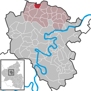
| Location of the Urmersbach community in the Cochem-Zell district | ||
  |
||

Urmersbach is a municipality in the Cochem-Zell district in Rhineland-Palatinate . It belongs to the Kaisersesch association.
geography
Urmersbach is in the Eastern Eifel . The Obermühle and Schuwerackerhof residential areas also belong to the community .
history
The place was first mentioned in a document in 1253.
Until the end of the 18th century, Urmersbach belonged to the rulers of Kurtrier and was assigned to the Kaisersesch office.
In 1794, French revolutionary troops annexed the Left Bank of the Rhine ; from 1798 to 1814 Urmersbach belonged to the canton of Kaisersesch in the Koblenz arrondissement of the Rhine-Moselle department . The municipal council (Urmersbacher community representative in the Mairie Kaisersesch) was 1808 the citizen Schmidt.
Due to the resolutions at the Congress of Vienna (1815), the region was assigned to the Kingdom of Prussia . Under the Prussian administration, the municipality of Urmersbach became part of the mayor's office in Kaisersesch in the Cochem district , which belonged to the new administrative district of Koblenz and, from 1822, to the Rhine province .
The municipality of Urmersbach has been part of the state of Rhineland-Palatinate since 1946 , has belonged to the Kaisersesch association since 1968 and to the Cochem-Zell district since 1969 .
- Population development
The oldest number comes from the year 1612, where 11 incolae , i.e. families, are called, which roughly corresponds to a population of 70. In 1787 the place had 233 inhabitants. At the end of 1999 there were 510 people in 229 families in Urmersbach, 261 of whom were women and 249 men.
In 1787 the size of the district is given as 361 hectares and in 1789 with 623 acres of “land”. In 1925 433 hectares are mentioned, and today the area is 434 hectares.
The development of the population of Urmersbach, the values from 1871 to 1987 are based on censuses:

|
|
politics
Municipal council
The municipal council in Urmersbach consists of eight council members, who were elected in a personalized proportional representation in the local elections on May 26, 2019 , and the honorary local mayor as chairman.
coat of arms
|
|
Blazon : "The shield in silver, on it a red St. Andrew's cross, topped with two golden ears." |
| Justification of the coat of arms: The ears of corn crossed in the coat of arms indicate agriculture and the miller's trade, both of which have been the livelihood of the village population for centuries. |
Culture and sights
Cultural monuments
see the list of cultural monuments in Urmersbach
Parish Church of St. Andrew
The history of the parish church “St. Andreas ”goes back to a mention in a wisdom from 1574. The chapel patron St. Andreas is mentioned here for the first time in the boundary definition of the“ Polcher wood ”.
The chapel is first mentioned in 1613. In 1784 the chapel is described in documents as falling apart . In 1787 the chapel was rebuilt by the Lambertine Seminary with the help of the faithful. In 1791 the reconstruction was completed with the solemn consecration. A relic of this time is the gallery with an old oak beam as a backrest. The following slogan is carved on this: “ANNO 1792 YOU HAVE READ ME TO LOOK AT YOUR SOLET OF GOD. YOU LIE ON ME AS HONORED AND DON'T EVEN RECOGNIZE GOD THE LORD. I AM A LENE. PRAISE GOD I LET EICH FALL INTO THE LIGHT ”.
In 1954 the chapel was expanded and renovated in its current form according to the plans of the architect Böhr from Mayen.
Events
- Fair
- Every year the village fair in honor of St. Andrew takes place on the first weekend in September. The event, organized by the four associations of the Kirmesgesellschaft, is celebrated on Saturdays and Sundays in the marquee at the parish hall.
- Shooting festival
- Every year on the last Sunday in July, the St. Hubertus Schützenbruderschaft Urmersbach 1928 e. V. their traditional shooting festival with a large pageant.
traffic
On May 15, 1895, Urmersbach was connected to the Eifelquerbahn , which still runs through the town today.
Web links
- Local community Urmersbach on the website of the Kaisersesch association
- Literature about Urmersbach in the Rhineland-Palatinate state bibliography
Individual evidence
- ↑ State Statistical Office of Rhineland-Palatinate - population status 2019, districts, communities, association communities ( help on this ).
- ↑ State Statistical Office Rhineland-Palatinate (ed.): Official directory of the municipalities and parts of the municipality. Status: January 2018 [ Version 2020 is available. ] . S. 23 (PDF; 2.2 MB).
- ^ A b Wilhelm Fabricius : Explanations of the historical atlas of the Rhine Province, Volume 2: The map of 1789. Bonn 1898, p. 138.
- ↑ Handbook for the residents of the Rhine-Mosel Department , Koblenz: Prefecture-Buchdruckerey, 1808, p. 63 ff ( www.dilibri.de )
- ↑ Topographical-statistical overview of the government district of Coblenz , Coblenz: Hölscher, 1843, p. 39 ( www.dilibri.de )
- ↑ State Statistical Office Rhineland-Palatinate - regional data
- ^ The Regional Returning Officer Rhineland-Palatinate: Local elections 2019, city and municipal council elections

Alf | Alflen | Altlay | Alt-trimmed | Auderath | Bad Bertrich | Beilstein | Beuren | Binningen | Blankenrath | Brachtendorf | Bremm | Briedel | Brieden | Briedern | Brohl | Bruttig-Fankel | Büchel | Bullay | Cochem | Dohr | Durfus | Düngenheim | Ediger-Eller | Ellenz-Poltersdorf | Eppenberg | Serious | Eulgem | Faid | Felt | Forst (Eifel) | Forst (Hunsrück) | Gamling | Gevenich | Gillenbeuren | Greimersburg | Grenderich | Hambuch | Haserich | Hauroth | Hesweiler | Illerich | Kaifenheim | Kail | Kaisersesch | Kalenborn | Kliding | Klotten | Country core | Laubach | Leienkaul | Lie | Liesenich | Lütz | Lutzerath | Masburg | Mesenich | Medium- bodied | Möntenich | Moritzheim | Mosel core | Tired (Moselle) | Müllenbach | Neef | Nehren | Panzweiler | Peterswald -öffelscheid | Pomerania | Pünderich | Reidenhausen | Roes | Sankt Aldegund | Showers | Schmitt | Senheim | Sosberg | Tellig | Treis cards | Elms | Urmersbach | Urschmitt | Valwig | Wagenhausen | Walhausen | Hamlet | Wirfus | Wollmerath | Zell (Mosel) | Zettingen