
Panzweiler
| coat of arms | Germany map | |
|---|---|---|

|
Coordinates: 50 ° 1 ′ N , 7 ° 18 ′ E |
|
| Basic data | ||
| State : | Rhineland-Palatinate | |
| County : | Cochem cell | |
| Association municipality : | Zell (Moselle) | |
| Height : | 465 m above sea level NHN | |
| Area : | 3.85 km 2 | |
| Residents: | 262 (Dec. 31, 2019) | |
| Population density : | 68 inhabitants per km 2 | |
| Postal code : | 56865 | |
| Area code : | 06545 | |
| License plate : | COC, ZEL | |
| Community key : | 07 1 35 070 | |
| Association administration address: | Corray 1 56856 Zell (Moselle) |
|
| Website : | ||
| Local Mayor : | Winfried Theisen | |
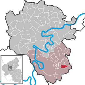
| Location of the local community Panzweiler in the district of Cochem-Zell | ||
  |
||

Panzweiler is a municipality in the Cochem-Zell district in Rhineland-Palatinate . It belongs to the Verbandsgemeinde Zell (Mosel) .
geography
Panzweiler is located in the Hunsrück , near the federal highway 421 . The local community covers 3.85 km², of which 1.32 km² is forest. Panzweiler also includes the Gassenhof and Lager residential areas .
history
In the area of Panzweiler as well as Walhausen, Löffelscheid, Grenderich and Moritzheim, the rubble of a number of smaller Roman villas lie in the ground. Immediately south of the place was a Roman settlement. The place is called in the years 1259 and 1276 as Panzwilre and belonged with Blankenrath to the parish of Mastershausen . In a letter from August 1576, which the Count Palatine of Simmern and the Margrave of Baden as Count of Sponheim, wrote to Philip the Elder Baron of Winneburg and Beilstein, Panzweiler and the village of Haserich, which is also disputed between these parties, are the property of the Duke of Jülich ( -Kleve-Berg). During the Sponheim rule, Panzweiler belonged to the Oberamt Kastellaun. The Panzweiler court consisted of the towns of Panzweiler (Simmern district) and Haserich (Zell district) and, like the Blankenrath court, formed a Kleve fiefdom. There were 25 Sponheim nurses and one sitter under the Hesweiler nursing school. From 1794 Panzweiler was under French rule and from 1798 to 1814 belonged to the canton of Zell in the Rhine-Moselle department . In 1815 the place was assigned to the Kingdom of Prussia at the Congress of Vienna . Since 1946 it has been part of the then newly formed state of Rhineland-Palatinate . Through the 8th Administrative Simplification Act of July 18, 1970 with effect from November 7, 1970, the community came from the Blankenrath community to the Zell (Mosel) community in the Cochem-Zell district.
- Statistics on population development
The development of the population of the municipality of Panzweiler, the values from 1871 to 1987 are based on censuses:
|
|
Municipal council
The council in Panzweiler consists of six council members, who in the local elections on May 26, 2019 in a majority vote were elected, and the honorary mayor as chairman.
See also

Town house in the center of the village
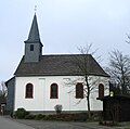
Chapel on the outskirts towards Blankenrath


Web links
- Literature about Panzweiler in the Rhineland-Palatinate state bibliography
Individual evidence
- ↑ a b State Statistical Office of Rhineland-Palatinate - population status 2019, districts, municipalities, association communities ( help on this ).
- ↑ State Statistical Office Rhineland-Palatinate (ed.): Official directory of the municipalities and parts of the municipality. Status: January 2018 [ Version 2020 is available. ] . S. 24 (PDF; 2.2 MB).
- ↑ State Statistical Office Rhineland-Palatinate - regional data
- ^ The Regional Returning Officer Rhineland-Palatinate: Local elections 2019, city and municipal council elections

Alf | Alflen | Altlay | Alt-trimmed | Auderath | Bad Bertrich | Beilstein | Beuren | Binningen | Blankenrath | Brachtendorf | Bremm | Briedel | Brieden | Briedern | Brohl | Bruttig-Fankel | Büchel | Bullay | Cochem | Dohr | Durfus | Düngenheim | Ediger-Eller | Ellenz-Poltersdorf | Eppenberg | Serious | Eulgem | Faid | Felt | Forst (Eifel) | Forst (Hunsrück) | Gamling | Gevenich | Gillenbeuren | Greimersburg | Grenderich | Hambuch | Haserich | Hauroth | Hesweiler | Illerich | Kaifenheim | Kail | Kaisersesch | Kalenborn | Kliding | Klotten | Country core | Laubach | Leienkaul | Lie | Liesenich | Lütz | Lutzerath | Masburg | Mesenich | Medium- bodied | Möntenich | Moritzheim | Mosel core | Tired (Moselle) | Müllenbach | Neef | Nehren | Panzweiler | Peterswald -öffelscheid | Pomerania | Pünderich | Reidenhausen | Roes | Sankt Aldegund | Showers | Schmitt | Senheim | Sosberg | Tellig | Treis cards | Elms | Urmersbach | Urschmitt | Valwig | Wagenhausen | Walhausen | Hamlet | Wirfus | Wollmerath | Zell (Mosel) | Zettingen