
Hauroth
| coat of arms | Germany map | |
|---|---|---|

|
Coordinates: 50 ° 15 ' N , 7 ° 6' E |
|
| Basic data | ||
| State : | Rhineland-Palatinate | |
| County : | Cochem cell | |
| Association municipality : | Kaisersesch | |
| Height : | 520 m above sea level NHN | |
| Area : | 3.94 km 2 | |
| Residents: | 318 (Dec. 31, 2019) | |
| Population density : | 81 inhabitants per km 2 | |
| Postal code : | 56761 | |
| Area code : | 02653 | |
| License plate : | COC, ZEL | |
| Community key : | 07 1 35 040 | |
| Association administration address: | Am Römerturm 2 56759 Kaisersesch |
|
| Website : | ||
| Local Mayor : | Stefan Schneider | |
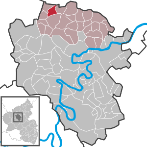
| Location of the local community Hauroth in the district of Cochem-Zell | ||
  |
||

Hauroth is a municipality in the Cochem-Zell district in Rhineland-Palatinate . It belongs to the Kaisersesch association.
geography
Hauroth is in the Eastern Eifel . The community also includes the Sonnenhof, Tannenhof and Wiesenhof residential areas .
history
Hauroth was first mentioned in 1103. Hauroth belonged to the late 18th century to kurtrierischen Office Monreal and the high court Masburg . The high court Masburg was a fiefdom of the Counts of Virneburg . In the Trier fire book from 1563 there are 14 fireplaces (households) in Hauroth ( Huroden ).
In 1794, French revolutionary troops annexed the Left Bank of the Rhine ; from 1798 to 1814, Hauroth belonged to the canton of Kaisersesch in the Koblenz arrondissement of the Rhine-Moselle department . The municipal council (Haurother community representative in the Mairie Kaisersesch) was in 1808 the citizen Theisen.
Due to the resolutions at the Congress of Vienna (1815), the region was assigned to the Kingdom of Prussia . Under the Prussian administration, the community of Hauroth came to the mayor's office of Kaisersesch in the district of Cochem , which belonged to the new administrative district of Koblenz and from 1822 to the Rhine province .
The municipality of Hauroth has been part of the state of Rhineland-Palatinate since 1946 , has belonged to the Kaisersesch association since 1968 and to the Cochem-Zell district since 1969 .
politics
Municipal council
The council in Hauroth consists of eight council members, who in the local elections on May 26, 2019 in a majority vote were elected, and the honorary mayor as chairman.
coat of arms
|
|
Blazon : “Divided by a slanted silver wavy bar of red and green. Above is an openwork, round arched golden window, divided by three staggered pointed arches set with noses. Below three golden ears of corn. " |
literature
- Ingeborg Scholz: Hauroth and its history. For the 900th anniversary of an Eifel village. 2003, ISBN 3-89801-301-4 .
See also
Web links
- Website of the local community Hauroth (without legal notice)
- Local community Hauroth on the website of the Kaisersesch community community
- Literature about Hauroth in the Rhineland-Palatinate State Bibliography
Individual evidence
- ↑ State Statistical Office of Rhineland-Palatinate - population status 2019, districts, communities, association communities ( help on this ).
- ↑ State Statistical Office Rhineland-Palatinate (ed.): Official directory of the municipalities and parts of the municipality. Status: January 2019 [ Version 2020 is available. ] . S. 34 (PDF; 3 MB).
- ^ Wilhelm Fabricius : Explanations of the historical atlas of the Rhine Province, Volume 2: The map of 1789. Bonn 1898, pp. 138, 155, 210.
- ↑ Handbook for the residents of the Rhine-Moselle department . Prefecture-Buchdruckerey, Koblenz 1808, p. 65 ( dilibri.de ).
- ^ Topographical-statistical overview of the government district of Coblenz . Hölscher, Coblenz 1843, p. 38 ( dilibri.de ).
- ^ The Regional Returning Officer Rhineland-Palatinate: Local elections 2019, city and municipal council elections

Alf | Alflen | Altlay | Alt-trimmed | Auderath | Bad Bertrich | Beilstein | Beuren | Binningen | Blankenrath | Brachtendorf | Bremm | Briedel | Brieden | Briedern | Brohl | Bruttig-Fankel | Büchel | Bullay | Cochem | Dohr | Durfus | Düngenheim | Ediger-Eller | Ellenz-Poltersdorf | Eppenberg | Serious | Eulgem | Faid | Felt | Forst (Eifel) | Forst (Hunsrück) | Gamling | Gevenich | Gillenbeuren | Greimersburg | Grenderich | Hambuch | Haserich | Hauroth | Hesweiler | Illerich | Kaifenheim | Kail | Kaisersesch | Kalenborn | Kliding | Klotten | Country core | Laubach | Leienkaul | Lie | Liesenich | Lütz | Lutzerath | Masburg | Mesenich | Medium- bodied | Möntenich | Moritzheim | Mosel core | Tired (Moselle) | Müllenbach | Neef | Nehren | Panzweiler | Peterswald -öffelscheid | Pomerania | Pünderich | Reidenhausen | Roes | Sankt Aldegund | Showers | Schmitt | Senheim | Sosberg | Tellig | Treis cards | Elms | Urmersbach | Urschmitt | Valwig | Wagenhausen | Walhausen | Hamlet | Wirfus | Wollmerath | Zell (Mosel) | Zettingen