
Urschmitt
| coat of arms | Germany map | |
|---|---|---|

|
Coordinates: 50 ° 7 ' N , 7 ° 4' E |
|
| Basic data | ||
| State : | Rhineland-Palatinate | |
| County : | Cochem cell | |
| Association municipality : | Elms | |
| Height : | 390 m above sea level NHN | |
| Area : | 6.61 km 2 | |
| Residents: | 185 (Dec. 31, 2019) | |
| Population density : | 28 inhabitants per km 2 | |
| Postal code : | 56825 | |
| Area code : | 02677 | |
| License plate : | COC, ZEL | |
| Community key : | 07 1 35 085 | |
| LOCODE : | DE R7G | |
| Association administration address: | Marktplatz 1 56766 Ulmen |
|
| Website : | ||
| Local Mayor : | Peter Jahnen | |
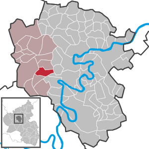
| Location of the Urschmitt community in the Cochem-Zell district | ||
  |
||

Urschmitt is a municipality in the Cochem-Zell district in Rhineland-Palatinate . It belongs to the Ulmen community .
geography
Urschmitt is eight kilometers southwest of the city of Cochem and four kilometers northwest of the Moselle . The village extends over a comparatively flat area east of the Blinzberg hill ( 430 m above sea level ). Geographically , the municipality of leaves Gevenicher plateau in the Eastern Moseleifel assign, in the here the valleys and side valleys of to earth Bach and Ellerbachs cut. The eastern half of the municipality includes part of the Cochem State Forest . It reaches its lowest point on the ground at 165 m above sea level. NHN at the southern exit of the Erlenbach from the district. The Forsthaus Sommet residential area belongs to Urschmitt .
Urschmitt borders (clockwise) on the local communities of Weiler , Dohr , Ediger-Eller , Kliding and Lutzerath .
At the end of the 1960s, RWE planned the large Bremm pumped storage plant . Its six-kilometer-long Obersee in the immediately west of Erdenbachtal and the smaller Untersee in eastern Ellerbachtal would have markedly delimited the ridge with Urschmitt, Kliding and Beuren on both sides along state road 106.
history
Urschmitt is first mentioned in 980 - at that time still under the name Ursmadia . The rule of Kurtrier ended with the occupation of the left bank of the Rhine in 1794/96 by French revolutionary troops . In 1815 the place was assigned to the Kingdom of Prussia at the Congress of Vienna . Urschmitt and Kliding , which formed one municipality, were divided in 1848. Since 1946 the place has been part of the state of Rhineland-Palatinate .
- Population development
The development of the population of Urschmitt, the values from 1871 to 1987 are based on censuses:
|
|
Municipal council
The municipal council in Urschmitt consists of six council members, who were elected by a majority vote in the local elections on May 26, 2019 , and the honorary local mayor as chairman.
Attractions
Urschmitt has few historical monuments, the church was built in 1910. The altar of the parish church of St. Quirinus , however, comes from the former Stuben monastery . Directly opposite the church is a traditional half-timbered house, as was common back then. Another half-timbered house is now in the Kommern open-air museum , it was dismantled stone by stone and rebuilt there.
See also:
Personalities
- Herbert Schneiders (* 1953), politician
Web links
- Urschmitt parish
- Urschmitt local community on the website of the Ulmen community
- Literature about Urschmitt in the Rhineland-Palatinate State Bibliography
Individual evidence
- ↑ a b State Statistical Office of Rhineland-Palatinate - population status 2019, districts, municipalities, association communities ( help on this ).
- ↑ State Statistical Office Rhineland-Palatinate (ed.): Official directory of the municipalities and parts of the municipality. Status: January 2018 [ Version 2020 is available. ] . S. 23 (PDF; 2.2 MB).
- ↑ State Statistical Office Rhineland-Palatinate - regional data
- ^ The Regional Returning Officer Rhineland-Palatinate: Local elections 2019, city and municipal council elections

Alf | Alflen | Altlay | Alt-trimmed | Auderath | Bad Bertrich | Beilstein | Beuren | Binningen | Blankenrath | Brachtendorf | Bremm | Briedel | Brieden | Briedern | Brohl | Bruttig-Fankel | Büchel | Bullay | Cochem | Dohr | Durfus | Düngenheim | Ediger-Eller | Ellenz-Poltersdorf | Eppenberg | Serious | Eulgem | Faid | Felt | Forst (Eifel) | Forst (Hunsrück) | Gamling | Gevenich | Gillenbeuren | Greimersburg | Grenderich | Hambuch | Haserich | Hauroth | Hesweiler | Illerich | Kaifenheim | Kail | Kaisersesch | Kalenborn | Kliding | Klotten | Country core | Laubach | Leienkaul | Lie | Liesenich | Lütz | Lutzerath | Masburg | Mesenich | Medium- bodied | Möntenich | Moritzheim | Mosel core | Tired (Moselle) | Müllenbach | Neef | Nehren | Panzweiler | Peterswald -öffelscheid | Pomerania | Pünderich | Reidenhausen | Roes | Sankt Aldegund | Showers | Schmitt | Senheim | Sosberg | Tellig | Treis cards | Elms | Urmersbach | Urschmitt | Valwig | Wagenhausen | Walhausen | Hamlet | Wirfus | Wollmerath | Zell (Mosel) | Zettingen