Reidenhausen
| coat of arms | Germany map | |
|---|---|---|

|
Coordinates: 50 ° 3 ′ N , 7 ° 19 ′ E |
|
| Basic data | ||
| State : | Rhineland-Palatinate | |
| County : | Cochem cell | |
| Association municipality : | Zell (Moselle) | |
| Height : | 445 m above sea level NHN | |
| Area : | 2.06 km 2 | |
| Residents: | 169 (Dec. 31, 2019) | |
| Population density : | 82 inhabitants per km 2 | |
| Postal code : | 56865 | |
| Area code : | 06545 | |
| License plate : | COC, ZEL | |
| Community key : | 07 1 35 074 | |
| Association administration address: | Corray 1 56856 Zell (Moselle) |
|
| Website : | ||
| Local Mayor : | Christian Klemm | |
| Location of the local community Reidenhausen in the district of Cochem-Zell | ||
Reidenhausen is a municipality in the district of Cochem-Zell in Rhineland-Palatinate . It belongs to the Verbandsgemeinde Zell (Mosel) .
geography
Reidenhausen is located on a ridge in the northern Hunsrück that slopes down towards the Moselle .
history
An old long-distance route, the Keltenweg Nahe-Mosel, runs over this ridge . A stately burial mound on the outskirts, where this path leads past, proves that the district is old settlement land .
Reudinhusin is mentioned in a document around 1310 . Reidenhausen (at times also Rodenhausen ), which formed a municipality with Blankenrath , was separated from the neighboring town in 1794 under French rule . From 1798 to 1814 the place belonged to the canton of Zell in the Rhein-Mosel-Département . 1815, the region and thus Reidenhausen on the Congress of Vienna the Kingdom of Prussia and from that first the mayor Senheim , later the mayor Blankenrath in county cell associated. Since 1946 the place has been part of the state of Rhineland-Palatinate . Through the 8th Administrative Simplification Act of July 18, 1970 with effect from November 7, 1970, the municipality of Reidenhausen came to the Verbandsgemeinde Zell (Mosel) after the dissolution of the Verbandsgemeinde Blankenrath .
politics
Municipal council
The council in Reidenhausen consists of six council members, who in the local elections on May 26, 2019 in a majority vote were elected, and the honorary mayor as chairman.
coat of arms
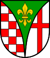
| Blazon : “A curled, overturned point, inside a golden lily in green, split; front red-silver box , behind in silver a red bar cross. " | |
| Foundation of the coat of arms: Maria has been the church patroness since the existence of a chapel. The attribute of the Mother of God is the lily. The green color is supposed to indicate the only source of income for centuries, agriculture. The red / silver box comes from the Sponheim coat of arms ; until the 18th century they had ownership claims on the entire Hunsrück. The red bar cross indicates the former rule of Kurtrier . |
See also
Web links
- Website of the community of Reidenhausen
- Literature about Reidenhausen in the Rhineland-Palatinate state bibliography
Individual evidence
- ↑ State Statistical Office of Rhineland-Palatinate - population status 2019, districts, communities, association communities ( help on this ).
- ^ The Regional Returning Officer Rhineland-Palatinate: Local elections 2019, city and municipal council elections


