
Moselle cycle path

The German Moselle Cycle Route is a long -distance cycle route along the Moselle and is part of the international Velo Tour Moselle cycle route . The Moselle rises in the Vosges , at 715 m above sea level. NN height, on the west side of the Col de Bussang . The signage for the French part begins in Metz . The German part starts in Perl and leads to the mouth of the Moselle in the Rhine at the Deutsches Eck in Koblenz . The total length from Metz is 311 km, that of the German part 239 km. The cycle route is a typical river cycle path with no significant inclines. The German part is on asphalt bike paths, either on its own route or alongside the road and is therefore also suitable for families.
Upper Moselle
Before Metz there are only a few bike paths along the Moselle. However, Metz is relatively easy to reach on mostly quiet country roads:
- Bussang , at an altitude of around 600 m, is only 4 km from the source. A signposted railway cycle path leads from the former train station to Remiremont (33 km).
- From Remiremont on the quiet D42 on the right side of the Moselle to Éloyes and Épinal (27 km).
- The end of the Canal des Vosges canal is in Epinal . You can follow it on cycle paths to lock 33 near Socourt (32 km).
- At the canal bridge change to the D570 road and follow it for 30 km. In Richardménil turn half left onto the D115 in the direction of Messein . About 1.5 km after Richardménil you come to a lock.
- Turn right at the lock and follow the signposted, paved cycle path on the right bank of the Canal de jonction de Nancy to Laneuveville-devant-Nancy . The route deviates here from the Moselle and crosses Nancy to cut off the wide arch of the Moselle around the city. Immediately after the bridge, take a sharp left and follow the towpath along the Marne-Rhine Canal to Nancy (16 km).
- In Nancy , the cycle path continues on the left bank of the Meurthe (not on the canal!) To the confluence with the Moselle near Pompey to the village of Custines (14 km).
- From here continue on the D40 on the right bank of the Moselle to Pont-à-Mousson (6 km).
- From Pont-à-Mousson, continue on the D657 to Jouy-aux-Arches , just before Metz (11 km).
- In Jouy-aux-Arches , behind the huge Roman aqueduct, a path leads left to the Moselle. The towpath on the right or left bank of a small canal leads to the center of Metz.
Route from Metz
Metz - Thionville
A new cycle path has been completed on this section since September 2010. It runs largely on the left bank of the Moselle and begins in Metz at the level of the campsite in the city center. Most of it is paved and easy to drive on.
(Length: 34 km; Metz at 173 m , Thionville at 159 m ).
Thionville - Perl / Schengen
From Thionville , the cycle route is usually well signposted as the Moselle cycle path on both sides of the Moselle. It runs close to the Moselle on towpaths, quiet country roads or asphalt farm roads. You will pass the towns of Malling , Contz-les-Bains and Sierck-les-Bains before reaching Perl on the German side of the Moselle or Schengen on the Luxembourg side.
(Length: 21 km; Thionville at 159 m , Perl at 146 m ).
Perl / Schengen - Trier

This is where the short Saarland part of the Moselle begins, which ends just after Nennig . The cycle path now runs close to the Moselle on its own route. In the area of waves , the Moselle is left and the place on the other side of the railway bypassed. In Oberbillig you can take the ferry to Wasserbillig where connection to the Sauer bike trail into Sauertal to Echternach and Vianden and continue on Nimstal- and Prümtal cycle path to Bitburg and Losheimergraben there. Shortly afterwards, the cycle path reaches Konz , where the Saar reaches the Moselle. The Saar cycle path also connects to the Moselle cycle path here. Trier is then reached after another 10 km.
(Length: 42 km; Perl at 146 m , Trier at 139 m ).
Trier - Neumagen-Dhron
Trier, as one of the oldest cities in Germany , is certainly the cultural highlight of the cycle route with its sights. This is also where the Kylltal cycle path branches off towards Gerolstein . From Trier the main route leads on the left side of the Moselle to Schweich , where you return to the right side to Longuich . The route then leads close to the Moselle via Leiwen to Neumagen-Dhron . The towns of Mehring and Trittenheim on the left bank of the Moselle can be easily reached via bridges along the way. To connect to the Ruwer-Hochwald-Radweg , you have to stay on the right side of the Moselle until Trier-Ruwer .
(Length: 40 km; Trier at 139 m , Neumagen-Dhron at 130 m above sea level).
Neumagen-Dhron - Traben-Trarbach
In Neumagen-Dhron , the Nahe-Hunsrück-Mosel cycle path turns right into the Hunsrück and connects the Moselle and Nahe . To Piesport on the left bank of the Moselle Mosel both sides are recommended as the main route. Thereafter, the main route returns to the right side back and attained by Bernkastel-Kues and Zeltingen , trotting-Trarbach . To find the connection to the Maare-Mosel-Radweg , you have to cross the Moselle in Mülheim . There you have to turn right and immediately after the brook bridge the bike path branches off to the left. Between Mülheim and Wehlen , both sides of the Moselle are recommended as the main route. On the left the route leads over the Kues district and on the right the Moselle over the Bernkastel district of the town of Bernkastel-Kues, which has existed since 1905.
(Length: 46 km; Neumagen-Dhron at 130 m , Traben-Trarbach at 110 m ).
Traben-Trarbach - Cochem
From Traben-Trarbach , the main route continues on the right bank of the Moselle through many well-known wine towns such as Pünderich , before switching to the left bank of the Moselle shortly before Zell . In Alf , the Eifel volcano bike route branches off to the left in the direction of Adenau into the Eifel . On the opposite side of the Moselle, in Bullay , there is again a connection to rail traffic in the direction of Koblenz, after no more rail lines have accompanied the Moselle since Trier . The main route then continues through many small towns such as Bremm to the district town of Cochem , which is dominated by the Reichsburg .
(Length: 60 km; Traben-Trarbach at 110 m , Cochem at 86 m above sea level).
Cochem - Koblenz

On the last section there are a number of castles such as Eltz Castle near Moselkern , Pyrmont Castle near Treis-Karden and Ehrenburg and Thurant Castle near Kobern-Gondorf . The main route leads from Cochem to Treis-Karden on the left bank of the Moselle. Here it changes to the right, but you have to stay on the left to visit Eltz Castle in Moselkern and the connection to the Maifeld cycle path in Hatzenport . Shortly after Treis-Karden, the Hunsrück-Mosel cycle path branches off to the Schinderhannes cycle path in the Hunsrück. In Löf the main route changes back to the left side, where it continues to Koblenz. On this section, the well-known wine towns of Kobern-Gondorf and Winningen are passed along with others before the Deutsches Eck in Koblenz and thus the end of the cycle path is reached. In Koblenz you have the option of changing to the Rhine cycle path or, just a few kilometers away in Lahnstein, to the Lahn cycle path .
(Length: 54 km; Cochem at 86 m , Koblenz at 63 m ).
Landscape and culture
The Moselle rises at 715 m above sea level. NN in the Vosges on the west side of the Col de Bussang . From here it flows with a considerable gradient to Neuves-Maisons , from where it was made navigable by 14 barrages until it flows into the Rhine at the Deutsches Eck in Koblenz . It has to cover a distance of 544 km through many loops in the lower area. In Lorraine , the scenic part of the cycle path extends from the source ( 47 ° 53 ′ 22 ″ N , 6 ° 53 ′ 34 ″ E ) to Épinal . After that, the landscape on the Moselle is once again more attractive from the German border near Perl . From here the viticulture stretches almost continuously to the mouth. The bank mountains from the German border to Trier are still low , then they become higher and the Moselle meanders with its typical loops through the wine culture area to Briedel . Vineyard terraces shape the picture here and the Moselle divides the two low mountain ranges, Eifel and Hunsrück . Trier, as one of the oldest cities in Germany, offers 2000 years of history with interesting buildings from Roman times . The wine-growing villages and towns on both sides of the Moselle offer many sights, such as the Roman wine ship in Neumagen-Dhron , the Roman wine press facilities on the Middle Moselle , the medieval townscape of Bernkastel-Kues , the Art Nouveau in Traben-Trarbach or the Moselle - Franconian half-timbered house in Kröv . Between Zell and Koblenz, a number of castles line the Moselle, such as the Marienburg in the Zeller Land, the Reichsburg in Cochem , through Eltz Castle on the Maifeld to Thurant Castle on the Lower Moselle near Kobern-Gondorf . Finally, the Moselle flows through the city of Koblenz to flow into the Rhine at the Deutsches Eck .
Attractions

Moselle near Pont-a-Mousson
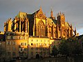
Saint-Etienne cathedral in Metz
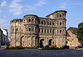
Porta Nigra in Trier

Reichsburg Cochem

Wine village of Winningen


- Bussang is located in the Ballons des Vosges Regional Nature Park .
- In Remiremont the first major tributary, which flows Moselotte in the Mosel. It is on the edge of the Ballons des Vosges Regional Nature Park .
- Éloyes located in the western foothills of the Vosges: Eglise de l'Assomption de Notre-Dame (Church of the Assumption of Our Lady) with a large painting of the Assumption of the Blessed Virgin Mary; Archaeological Museum.
- Épinal : Basilica of St-Maurice; Castle ruins.
- Nancy has a lovely old town. The Place Stanislas , the Place de la Carrière and the Place de l'Hémicycle , one of the most important ensembles enlightened absolutist urban were in the 1983 World Heritage List of UNESCO added. The squares were mainly laid out between 1752 and 1760 by the architect Emmanuel Héré .
- Pont-à-Mousson : The former Premonstratensian Abbey is located directly on the banks of the Moselle. Since 1964, the large monastery complex has been a cultural center and the seat of the European Center for Sacred Art.
- Jouy-aux-Arches : A Roman aqueduct towers over the houses of the village and ends just before the banks of the Moselle.
-
Metz offers a number of churches, such as the Gothic cathedral Saint-Étienne de Metz (with 6500 m² stained glass windows,designedby Marc Chagall among others), the Saint-Pierre-aux-Nonnains (also Saint-Pierre-de-la-Citadelle , Sankt Peter on the Citadel in the Rue de la Citadelle ), oldest known basilica in France from the 4th century; and Saint-Maximin (with window by Jean Cocteau ). In the city center there are a number of interesting squares such as Place Saint-Jacques and Place d'Armes , as well as the historic building complex from the fifteenth century, the Hôtel de Gargan . In addition, there are remains of the old city fortifications with several still preserved gates such as the Porte des Allemands (German Gate) and the Porte Serpenoise (Roman Gate).
(See also List of Monuments Historiques in Metz ). - Thionville : town houses and villas from the Wilhelmine era and from the fin de siècle era ; Fixed Obergentringen ( Fort de Guentrange ), 1899–1906.
- Sierck-les-Bains : In the center there are several houses from the late Gothic and Renaissance periods . The Sierck Castle above the town with towers and bastions from the 16th and 17th centuries has been preserved as an impressive ruin.
- By the Schengen Agreement known location Schengen has a landmark church and a castle and the remains of a moated castle from the 13th century. From Schengen, the “Luxembourg Wine Route” leads along the Moselle in a north-easterly direction to the mouth of the Sauer near Wasserbillig . On the German side, this wine-growing region is called the " Southern Wine Moselle ", which forms part of the Mosel-Saar-Ruwer wine-growing region .
- Conc : Roscheider Hof open-air museum; Karthaus Monastery : mouth of the Saar; “ Stones on the River ”sculpture trail; Historic oil mill in the Niedermennig district; Concert doctor fountain; Ruins of the imperial villa .
- Trier : The city was founded more than 2000 years ago under the name Augusta Treverorum ( Treveris from the second half of the 3rd century) and claims the title of the oldest city in Germany . Trier refers to the longest history as a city already recognized by the Romans , in contrast to a settlement or an army camp . The Roman monuments in Trier , consisting of amphitheater , Barbara Baths , Imperial Baths , Constantine Basilica , Porta Nigra , Roman Bridge , Igel Column , Cathedral and the Church of Our Lady count since 1986 UNESCO - World Heritage Site . A selection of medieval monuments are: Trier Cathedral St. Peter (oldest cathedral in Germany), the Church of Our Lady and the main market . The Electoral Palace , the Karl-Marx-Haus , Art Nouveau houses in Fleischstrasse and Nagelstrasse as well as Schloss Quint (Trier-Quint district)date back to the modern era.
- Schweich : old ferry tower ; Jewish cemetery ; Niederprümer Hof .
- Longuich : Roman Villa Urbana .
- Mehring : Roman Villa Rustica .
- Neumagen-Dhron : The Leugenstein ,builtunder Emperor Caracalla in 212 AD,indicates the distance to Trier as 15 Gallic Leugen = 33.3 km. It stands directly at the parish church of St. Maria Himmelfahrt and was one of the Leugensteine on the Roman road from Bingen to Trier. The Peterskapelle in the center of Neumagen was built around 1300. The cast of a Roman wine ship is also located here .
- Bernkastel-Kues : The medieval market square with its gabled half-timbered houses from the 17th century, with the narrow pointed house dating from 1416. A number of well-preserved buildings are groupedaround St. Michaelsbrunnen from 1606, such as the Renaissance town hall from 1608. Above the Bernkastel district lies the Landshut castle ruins , a former summer residence of the Archbishops of Trier , which was destroyed by fire in 1692.
- Kröv : three-gabled house (former town hall).
- Traben-Trarbach : ruins of the Grevenburg ; Mont Royal Fortress(1687–1698) (French fortress under Louis XIV ); Bridge gate of the Moselle bridge; Middle Moselle Museum on the history of the Moselle valley and the Mont Royal fortress; City tower in Trarbach with a view over the roofs of Trarbach.
- Zell : Marienburg Abbey ; several buildings of the former castle.
- Alf : Arras Castle .
- Bremm : The Bremmer Calmont is the steepest vineyard in Europe, with a via ferrata createdby the German Alpine Association . Only a ruin remains of theformer Stuben Monastery women's monastery .
- Cochem : Old town with historic half-timbered houses, market square, town hall and Martinsbrunnen. The former Bundesbank bunker in Cochem used as an emergency currency during the Cold War . The Reichsburg Cochem as well as the Winneburg castle ruinsand the St. Rochus plague chapel, known as the Peterskapelle.
- Treis-Karden : The former collegiate church of St. Castor (originally a Romanesque building) is known as the "Moselle Cathedral".
- Moselkern : The town hall from 1535 is the oldest town hall on the Moselle. Eltz Castle is in the immediate vicinity of the village.
- Alken : Thurant Castle .
- Kobern-Gondorf : Above the town of Kobern lies the upper castle from the 12th centuryon a mountain spur, and a little lower down the lower castle . The Oberburg Gondorf and Schloss Liebieg are located in Gondorf .
- Winningen : The wine-growing village has won several village beautification competitions and boasts of being one of the most beautiful villages in Germany .
- Koblenz : The city is one of the oldest cities in Germany and parts of the city are a UNESCO World Heritage Site . It owns a number of museums, including the Koblenz State Museum on the Ehrenbreitstein Fortress . In addition to the aforementioned fortress, there are a number of other castles and palaces ( Electoral Palace on the Rhine, Stolzenfels Castle , Old Castle ).

Rail connection
On the Upper Moselle, Remiremont train station is closest to the source. From here, via Epinal and Nancy to Thionville , the SNCF operates a route along the Moselle. The Obermoselbahn connects Thionville with Trier . This gives you the opportunity to cover selected stages by train on this part of the Moselle. Unfortunately, cross-border local passenger trains only run every two hours on weekends. The Moselle route between Trier and Koblenz leaves the Moselle valley behind Trier and only returns there in Bullay to then follow the Moselle valley to Koblenz. A branch line operates on the branch line between Bullay and Traben-Trarbach . It is therefore not possible to use the train between Trier and Traben-Trarbach. Koblenz as the end point of the cycle route is very well integrated into the Deutsche Bahn route network as a station on the left Rhine Valley route . The distance from the Deutsches Eck , the end point of the cycle path, to the main train station, is approx. 2.5 km along the Rhine promenade.
Connecting cycle paths
Connection in other directions is provided by the Saarland cycle path near Perl and Remich , the Sauertal cycle path near Wasserbillig , the Kylltal cycle path near Ehrang / Quint , the Maare-Mosel cycle path near Lieser , the Saar cycle path near Konz , the Ruwer- Hochwald cycle path near Ruwer / Eitelsbach , the Nahe-Hunsrück-Mosel cycle path at Neumagen-Dhron , the Eifel volcano route from Alf , the Hunsrück-Mosel cycle path from Treis-Karden , the Maifeld cycle path through the Schrumpftal from Hatzenport and the Rhine cycle path in Koblenz .
See also:
literature
- Moselle cycle path: with a trip to the Saar loop and a 3-country tour to Thionville, cycle route map 1: 50,000 BVA, Bielefeld 2009. ISBN 978-3-87073-462-6 .
- Cycling map - Leporello Moselle cycle path Perl - Koblenz, 1: 50,000, Publicpress-Verlag. ISBN 978-3-89920-198-7
- bikeline Radtourenbuch Mosel-Radweg, From Metz to the Rhine, 1: 50,000, Verlag Esterbauer, 14th edition 2014, ISBN 978-3-85000-637-8
Web links
- Link to map and elevation profile
- Mosel , at www.radreise-wiki.de, accessed in November 2011
- Moselle Cycle Route Height profile and GPS overlay data for the German part at the Land Survey Office of Rhineland-Palatinate ( Memento from March 1, 2016 in the Internet Archive )
- Info boards:
- Cycling paradise Saar-Obermosel Discover something special (PDF; 2.2 MB)
- Moselle Cycle Path from Thorn Castle to Koblenz (PDF; 2.3 MB)
- Connection to regioradler buses in Rhineland-Palatinate
- Mosel-Radweg , on radwanderland.de, accessed in November 2011
Individual evidence
- ↑ Moselle cycle path from Thionville to Koblenz , at www.tourenplaner-rheinland-pfalz.de, accessed on January 10, 2018
Coordinates: 49 ° 28 ' N , 6 ° 22' E