
Hatzenport
| coat of arms | Germany map | |
|---|---|---|

|
Coordinates: 50 ° 14 ' N , 7 ° 25' E |
|
| Basic data | ||
| State : | Rhineland-Palatinate | |
| County : | Mayen-Koblenz | |
| Association municipality : | Rhine-Moselle | |
| Height : | 85 m above sea level NHN | |
| Area : | 3.77 km 2 | |
| Residents: | 603 (Dec. 31, 2019) | |
| Population density : | 160 inhabitants per km 2 | |
| Postal code : | 56332 | |
| Area code : | 02605 | |
| License plate : | MYK, MY | |
| Community key : | 07 1 37 208 | |
| Association administration address: | Bahnhofstrasse 44 56330 Kobern-Gondorf |
|
| Website : | ||
| Local Mayor : | Thorsten Herbert Menzel | |
| Location of the local community of Hatzenport in the Mayen-Koblenz district | ||
 |
||


Hatzenport is a municipality in the Terrassenmosel in the Mayen-Koblenz district in Rhineland-Palatinate . It belongs to the Rhein-Mosel community , which has its administrative headquarters in Kobern-Gondorf . The residential areas Am Bischofstein and Betzemerhof also belong to Hatzenport .
history
The name is derived from the Latin name Hattonis porta , which means the port or gate of the Archbishop of Trier Hetti (term of office 814-847).
Hatzenport was first mentioned in a document (without proof) in 1135. Viticulture is documented for the first time in 1216. Today's municipality of Hatzenport was created on June 12, 1994 by hiving off the district of the same name from the municipality of Löf . Previously, the community of Löf was newly formed on December 31, 1975 from the previously independent communities of Hatzenport, Kattenes and Löf.
politics
Municipal council
The municipal council in Hatzenport consists of twelve council members, who were elected in a personalized proportional representation in the local elections on May 26, 2019 , and the honorary local mayor as chairman. The twelve seats are divided between four groups of voters .
mayor
Thorsten Herbert Menzel became the local mayor of Hatzenport on June 19, 2019. In the direct election on May 26, 2019, he was elected for five years with 56.53% of the vote. Menzel is the successor to Albrecht Gietzen, who after 25 years in office did not run for this position.
Attractions
The landmark of the Moselle town is the old ferry tower (the foundation stone was laid in 1863). The ferry service, which has been important since the 16th century, was discontinued after the Löf / Alken bridge was built in 1972. Other sights are the old Gothic parish church of St. Johannes above the village , the new Catholic parish church of St. Rochus , built by Hermann Nebel in 1869/70, and the old rectory, a half-timbered building located below the old church in Oberstraße; There is a cider cellar there today.
See also: List of cultural monuments in Hatzenport

Ferry tower on the banks of the Moselle
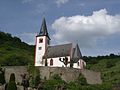
Johanneskirche in the vineyards


Economy and Infrastructure
Viticulture
Hatzenport belongs to the "Burg Cochem wine-growing area " in the Moselle growing region . Five wineries are active in the village, and the area under vines is 12 hectares. About 88% of the wine grown are white grape varieties (as of 2010).
- Vineyards (seen downstream from the Moselle)
- Hatzenporter Castle Bischofstein
- Hatzenporter Kirchberg
- Hatzenporter Stolzenberg
traffic
Hatzenport has a train station on the Moselle route . Since 2005 there has been a new station building in the middle of the village, the former station is in the direction of Burg Bischofstein and was shut down when the new station opened. The following trains serve the station:
| line | designation | Line course | Clock frequency |
|---|---|---|---|
| RB 81 | Moselle Valley Railway | Koblenz - Hatzenport - Cochem - Bullay (DB) - Wittlich - Trier | 60 min (in the HVZ amplifier Koblenz - Cochem) |
There is also a bus connection to Münstermaifeld and Treis-Karden .
Personalities
- Stefan Wilkening (* 1967), actor and speaker
literature
- Joh. August Klein: The Moselle valley between Koblenz and Konz. Historic, topographical, picturesque. Koblenz 1831.
Web links
- Internet presence of the local community Hatzenport
- History and tourism
- Literature about Hatzenport in the Rhineland-Palatinate state bibliography
Individual evidence
- ↑ State Statistical Office of Rhineland-Palatinate - population status 2019, districts, communities, association communities ( help on this ).
- ↑ State Statistical Office Rhineland-Palatinate (ed.): Official directory of the municipalities and parts of the municipality. Status: January 2019 [ Version 2020 is available. ] . S. 44 (PDF; 3 MB).
- ↑ This name declaration was confused. first made by JA Klein, 1831. He gave the local pastor Platten as an informant. Klein quotes the demolition of a rock passage by "a bishop Hetti or Hatto": ... at least that is what monastery reports say "in Moselthal ... , pp. 121–122
- ↑ Mittelrheinisches Urkundenbuch (MRUB) III, No. 56
- ↑ Official municipality directory (= State Statistical Office of Rhineland-Palatinate [Hrsg.]: Statistical volumes . Volume 407 ). Bad Ems February 2016, p. 184 (PDF; 2.8 MB; footnotes 22 and 38).
- ↑ Regional Returning Officer Rhineland-Palatinate: Municipal elections 2019 City and municipal council elections
- ^ The Regional Returning Officer Rhineland-Palatinate: direct elections 2019. see Rhein-Mosel, Verbandsgemeinde, sixth result line. Retrieved January 11, 2020 .
- ^ Rhein-Mosel Info: Constituent meeting of the local council. (PDF, page 12) Linus Wittich Medien GmbH, edition 26/2019, accessed on January 11, 2020 .
- ↑ Peter Karges: Looking back on 25 years as local mayor: Albrecht Gietzen tells of successes and disappointments. Rhein-Zeitung, June 12, 2019, accessed on January 11, 2020 .
- ↑ State Statistical Office Rhineland-Palatinate - regional data
- ↑ Krieger, Joachim: Terrassenkultur an der Untermosel, Joachim Krieger Verlag, Neuwied 2003

Eight | Alkene | Andernach | Look | Arft | Baar | Bassenheim | Bell | Bendorf | Bermel | Boos | Brey | Brodenbach | Castles | Thieving | Ditscheid | Agree | Ettringen | Gappenach | Low | Gierschnach | Hatzenport | Hausten | Herresbach | Shepherds | Cold | Kaltenengers | Sweeping | Notches | Chained | Kirchwald | Kobern-Gondorf | Kollig | Kottenheim | Kretz | Kruft | Langenfeld | Langscheid | Clay | Lind | Löf | Lonnig | Luxem | Quirks | Mayen | Mendig | Mertloch | Monreal | Mülheim-Kärlich | Münk | Münstermaifeld | Night home | Naunheim | Nickenich | Niederfell | Niederwerth | Nörtershausen | Upper skin | Notice | Pillig | Plaidt | Polch | Reudelsterz | Rhens | Vineyards | Over | Saffy | Sankt Johann | Saint Sebastian | Siebenbach | Spay | Door | Trimbs | Urbar | Urmitz | Vallendar | Virneburg | People's field | Waldesch | Hamlet | Weißenthurm | Weitersburg | Welling | Welschenbach | Wierschem | Winningen | Clouds