
Münstermaifeld
| coat of arms | Germany map | |
|---|---|---|

|
Coordinates: 50 ° 15 ' N , 7 ° 22' E |
|
| Basic data | ||
| State : | Rhineland-Palatinate | |
| County : | Mayen-Koblenz | |
| Association municipality : | Maifeld | |
| Height : | 271 m above sea level NHN | |
| Area : | 27.79 km 2 | |
| Residents: | 3449 (Dec. 31, 2019) | |
| Population density : | 124 inhabitants per km 2 | |
| Postcodes : | 56294, 56754 (Pilligerheck) |
|
| Area code : | 02605 | |
| License plate : | MYK, MY | |
| Community key : | 07 1 37 501 | |
| LOCODE : | DE 83A | |
| City structure: | 5 districts and 2 residential spaces | |
| Association administration address: | Marktplatz 4 56751 Polch |
|
| Website : | ||
| City Mayor : | Claudia Schneider ( CDU ) | |
| Location of the city of Münstermaifeld in the Mayen-Koblenz district | ||
 |
||

Münstermaifeld ( dialect : Meenster ) is a town in the Mayen-Koblenz district in Rhineland-Palatinate . It is located on the Maifeld and belongs to the association of the same name , which has its administrative headquarters in Polch . Münstermaifeld is designated as a basic center according to state planning .

geography
Geographical location
Münstermaifeld is not far from the Moselle in the center of the front Maifeld, a plateau that belongs to the Eifel region between the Lower Moselle and the Middle Rhine . The city is dominated by the mighty westwork of its cathedral, visible from afar . Its scenic location allows a good view of the Nürburg , the Hohe Acht , the massif on the Laacher See and far into the Eifel and the Moselle and Hunsrück heights .
City structure
Münstermaifeld includes the districts of Keldung, Küttig, Lasserg , Metternich, Mörz, as well as the residential areas Pilliger Heck and Sevenich.
Message
The place is located southwest of the city on the edge of the Elztal between the castles Eltz and Pyrmont . The core area was first mentioned in the 12th century under the name Cheldin. After 1950, an agricultural settlement for displaced persons was set up in Keldung .

Küttig
Küttig is a place north of Münstermaifeld. The place name appeared for the first time in an exchange document from 963/964. Large agricultural estates still bear witness to the early courts of the nobility or clerical institutions, which, however, only become tangible in the 14th century.
Lasserg
Lasserg is located on the high plateau facing the Moselle south of the city. The chapel in the center of the village is dedicated to St. Benedict and has a Romanesque core. The renovation took place in 1729. Numerous houses from the 17th and 18th centuries have also been preserved.
Metternich
The 'Metternich' district in the southeast is first mentioned in 1187. Until the end of the Old Kingdom he belonged to the Oberamt Münstermaifeld.
Mörz
Mörz is in the east of the city. The Trier Abbey of St. Maximin had property in Mörz around 1200, which was then called Muderce . A spacious courtyard from 1774, which can still be seen, belonged to the real estate of the imperial abbey of St. Maximin in Trier until it was auctioned in the French period in 1812 . According to reports from the church authorities, there was a chapel in Mörz in 1656. Today's church has stood there in the center of the hillside since 1802.
climate

The annual precipitation is 653 mm. This puts it in the lower third of the values recorded in Germany. Lower values are registered at 31% of the measuring stations of the German Weather Service . The driest month is February, with the most rainfall in July. In July there is 1.8 times more rainfall than in February. In 2009, 47 summer days (Tmax> = 25 ° C) and 1942 hours of sunshine were registered. There were 40.7% more hours of sunshine than the long-term average. The Münstermaifeld weather station (type AME66) is located northwest of the city. The coordinates are: longitude 7 ° 21 13 ", latitude 50 ° 15'22".
history
The Maifeld in front of the Eifel is fertile farmland that was settled early on. There are archaeological finds from the Stone Age and the later Celtic settlement . After the Germanic tribes conquered Trier, the Frankish settlement began here too . There was a Franconian cemetery in the vicinity of the Martinskirche.
The original construction of the Martinskirche, the later collegiate church, goes back to the Merovingian period, to the years 573 to 596. It was built on the foundations of a Roman watchtower and served as a regional center of Christianization.
In 965 Münstermaifeld was granted market rights .
There is evidence that Bruno von Lauffen consecrated the previous building of the collegiate church of St. Martin and St. Severus in 1103. As an important bastion against Kurköln , Münstermaifeld was interesting for him as Archbishop of Trier . He was considered a skilful diplomat and was an influential advisor to Emperor Heinrich IV and his successor Heinrich V. At that time he probably began to provide the important market town of Münstermaifeld with a fortification. The “powder or owl tower” named after him in the vernacular “Lauffenburg” still stands today as part of the city fortifications of that time, which subsequent electors further strengthened.
Immediately in front of the westwork, on today's St. Peter's Square, stood the Capella Sancti Petri , a church first mentioned in 1308. During the construction period of the collegiate church, which dragged on for a long time, this Peterskirche served as a substitute parish church from the second half of the 13th century. As a central cultic institution, it was therefore adopted in the municipal seal image, which was first handed down in 1278.
Elector Arnold II of Isenburg expanded the city fortifications in the middle of the 13th century. He had both Münstermaifeld and Koblenz surrounded by ramparts and partially with a wall ( Monasterium oppidum in Meynevelt circumvallavit, et in parte murari fecit ). Trier Elector Heinrich II von Finstingen , the builder of the Genoveva Castle and the fortifications of Mayen , completed the city wall around 1280 - as did the Koblenz city wall. The fortification was in connection with the endeavor to suppress the influence of the Counts of Virneburg , who had become important rulers on the Maifeld.
Heinrich II von Finstingen granted Münstermaifeld jurisdiction on December 17, 1277 by setting up a fourteen- person jury chair and, as emphasized, put it on an equal footing with Koblenz. The document reads in the excerpt: “... that we, Heynrich (by godly Ertzbishop of the Trierischen) to announce to all present and descendants who see or hear this letter, that we are with careful advice and from the council brafer and good Leuth fourteen lay judges in our castle Münster in the Mayfelt made and set hain, which we are lent and want that they have the same freedom with all those there and our lay judges are happy ... " . A lengthy process came to an end with this certification and Münstermaifeld thus obtained the full rights of a city in the Electorate of Trier. The successors in office confirmed these rights during their tenure, so on March 13, 1295 Bohemond I. von Warnesberg , on September 14, 1300 Diether von Nassau and on January 24, 1309 Balduin of Luxembourg .
However, since the city fortifications soon no longer met the requirements of the time, Elector Baldwin of Luxembourg, brother of Emperor Henry VII , expanded and strengthened it again as part of a planned city expansion and added towers. It can be assumed that this work, which is attributed to Baldwin in a document from 1333 or 1335, was completed 10 to 15 years earlier. This is evidenced by the new tower ( noua turris Monasterii ) mentioned in 1323 , which was probably identical to the tower that was named Laufenburg as part of the city wall (domus (...) apud murum sub propugnacolo prope turrim dictam Lawenburg) .
The importance of Baldwin for Münstermaifeld is also reflected in the fact that in 1926 the then state German Oberschule was given permission to use the name "Kurfürst-Balduin-Schule" . The street that passed it was also named after him in 1929. When the school was converted into a full-time grammar school in 1980, the name "Kurfürst-Balduin-Gymnasium" was retained. Baldwin completed the "Minster on the Maifeld" and built the city on the border with Kurköln into a mighty bulwark.
Furthermore, Münstermaifeld had for a long time since the Middle Ages the right to mint as the Electorate of Trier .
There was also a special connection with Eltz Castle over the centuries . The Eltz gentlemen were active in the administration of the city throughout the late Middle Ages. In the former collegiate church there are also Eltz graves, particularly artistically the epitaphs of the couple Cuno (also Kuno) von Eltz (before 1475 - after February 5, 1529) and Ella (also Eva) von Esch (–1531), two relief plates Basaltic lava . The circumferential inscription on the wide frame band says: "Anno Domini MDXXIX (= 1529) Ingenuus Cono de Eltz fato functus his tumulatus cuius anima requiescat in pace." Also the marble grave of Nikolaus von Eltz and his wife Maria von Hoort, as well as a marble monument from their son Johann Wilhelm Antonius Bertramus Herr zu Eltz , in turn canon of Trier , can be found. The sons of those von Eltz were canons in the Münstermaifeld Monastery for centuries . Ending by many decades quarrel with the Pope was Lothar von Eltz known, the 1267 from the chapter on Monster Meynfelt to legally Praepositus had been elected. Elias von Eltz (1331–1347) was one of the most energetic of the pen.
During the Palatinate War of Succession , Münstermaifeld was almost completely destroyed. Two years after the arson on the orders of Louis XIV on March 27, 1689, a translation error led to another destruction: Marshal Louis-François de Boufflers had confused the name of the city with that of Münstereifel .
Extensive construction work has been carried out in the vicinity of the former collegiate church since 2009. In the course of this, the archaeologists of the General Directorate for Cultural Heritage Rhineland-Palatinate , Koblenz branch, examined a large medieval burial ground on the city's Stiftsplatz. Far more than 400 uncovered graves testify to the history of the place. Around 40 graves contained graves from the younger Merovingian era . With their complete weapons equipment, precious pieces of jewelry made of gold and silver, bronze, glass and imported vessels, they testified to the wealth of the wealthy upper class, who ruled here for several generations in the 7th and first half of the 8th century. Some of the exhibits have been on view in the Maifeld Archaeological Museum since 2014 .
Incorporations
With effect from December 31, 1975, the five previously independent municipalities of Keldung (194 inhabitants), Küttig (153 E.), Lasserg (234 E.), Metternich (173 E.) and Mörz (145 E.) became part of the municipality Münstermaifeld incorporated.
City rights
In the 13th century the place was given city rights. The Münstermaifelder town seal, first attested in 1278, measures approx. 7 cm in diameter. The seal inscription reads: Sigillum civitatis Monasterii in Meinfelt (seal of the city of Münstermaifeld) . It was renewed on July 2, 1977 by the Interior Minister of Rhineland-Palatinate .

politics
City council
The city council of Münstermaifeld consists of 20 council members, who were elected in a personalized proportional representation in the local elections on May 26, 2019 , and the honorary city mayor as chairman.
The distribution of seats in the city council:
| choice | SPD | CDU | ÖDP | Per MM | Green | total |
|---|---|---|---|---|---|---|
| 2019 | 4th | 7th | 1 | 5 | 3 | 20 seats |
| 2014 | 4th | 8th | 2 | 6th | - | 20 seats |
| 2009 | 6th | 7th | 1 | 6th | - | 20 seats |
| 2004 | 8th | 7th | 0 | 5 | - | 20 seats |
- Pro MM = Pro-M'm - Citizens' Policy for Münstermaifeld e. V.
mayor
The city mayors of Münstermaifeld:
- until 2009 Maximilian Mumm
- 2009–2014 Robert Müller
- since 2014 Claudia Schneider (CDU)
In the direct election on May 26, 2019, she was confirmed in her office for a further five years with a share of 76.02% of the votes.
Districts
According to its main statute, the city of Münstermaifeld has formed five local districts. The election of local councils is not planned.
The mayors of the districts are: Klaus Müller (Keldung), Peter Gansen (Küttig), Heike Brücher (Lasserg), Uwe Krause (Metternich) and Andrej Kühn (Mörz).
Alderman
The city has as its main statutes up to three councilors .
coat of arms
|
|
Blazon : “In silver an open red city gate, inside an upright, left-turned red key; on both sides, above a red battlement wall, a two-tower, blue-roofed red church; golden crosses on gate and towers. " |
| Justification of the coat of arms: This coat of arms, confirmed by King Wilhelm II of Prussia in 1901, is the image of the oldest seal attested to since 1281. The key of the patron saint St. Petrus points to the rule of the electors of Trier, who fortified the place in the 13th century and gave it freedom in 1275. The image of the jury's seal from around 1400 is similar, in which two church-like buildings also appear. From the secret seal of the 14th century, which contains the Trier cross with a key in the heart shield, the actual city coat of arms developed, which was also attached to the town hall in the 16th century. |
Town twinning
- Les Pavillons-sous-Bois ( Seine-Saint-Denis department ) since 2018
Culture and sights

St. Martin and St. Severus
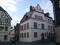
town hall

Door at the town hall

Tombs of the Weckbecker family

Holy grave sculpture in the Maifeldmünster

Lauffenburg / Pulverturm, aerial photo (2015)

Water tower, aerial photo (2015)

Historical city view on an emergency banknote from 1921


- Old buildings, including the historic town hall and romantic half-timbered houses, as well as remains of the old city fortifications bear witness to the historical past.
- Gothic collegiate church of St. Martin and St. Severus
- Local history museum in the old provost house
- Maifeld Archaeological Museum
- Farm museum in the center of the village
- Remains of the historic city wall
- Former synagogue on Severusstrasse
- Tombs of the Weckbecker family by Vinzenz Statz
- Water tower from 1893. Decommissioned in 1955, today accessible as an observation tower as part of guided tours .
- Lauffenburg, also called owl or powder tower; the only preserved tower of the city fortifications.
- Schöneck Castle
- Eltz Castle , about 5 km from Münstermaifeld
- Pyrmont Castle , about 5 km from Münstermaifeld
- Bischofstein Castle on the Moselle in the district of Lasserg in Münstermaifelde
- First work by the organ builder Stumm from 1722 in the collegiate church
→ See also: List of cultural monuments in Münstermaifeld
Economy and Infrastructure
education
- Kunterbunt and Dandelion day care centers
- Cusanus School ( primary school )
- Kurfürst-Balduin-Gymnasium
- Community College
- Youth meeting old fire brigade
leisure
- outdoor pool
- Tennis court
- sports ground
- Federal bowling alley
- DFB mini pitch
- Shooting range
- Boules alley
Infrastructure
traffic
Rail transport
In 1916 Münstermaifeld received a rail connection for goods and passenger traffic via the Koblenz – Lützel – Polch line, which opened on October 1, 1904, with its own branch line Polch – Münstermaifeld , after a company from Koblenz had tried unsuccessfully in March 1890 to obtain a concession for to apply for a railway line from Kobern-Gondorf (Mosel) via Münstermaifeld and Polch to Mayen. After the failure of this project, Münstermaifeld only received a rail connection 26 years later. Work on the branch line branching off from Polch to Münstermaifeld began in 1912. The construction work was delayed due to the outbreak of the First World War, so that the 10.13 km long line could only be opened on March 16, 1916. Unfortunately, due to the lack of a connection to the Moselle, hopes were not fulfilled and passenger traffic on the route was stopped on September 30, 1961. Freight traffic, which was mainly used to ship agricultural products (primarily sugar beets, but also other products from local farmers), continued until March 15, 1982. On December 9, 1983, the line was closed and then dismantled. In the 1990s, a near-natural cycle path via Polch to Mayen and Ochtendung was set up on the former railway line.
Personalities
Honorary citizen of the city
- Hermann Josef Doetsch (October 31, 1946)
- Peter Geis (1952)
- Peter Weendung (July 1, 2005)
- Gerd Müller (June 18, 2007)
- Dieter Müller (June 16, 2011)
- Bernd Halfen (October 3, 2019)
Born in Münstermaifeld
- Jakob von Eltz (1510–1581), Elector and Archbishop of Trier
- Franz Georg Severus Weckbecker (1775–1862), merchant and manor owner
- Franz Josef Ignaz Canaris (≈ July 31, 1791; † June 15, 1828), great-grandfather of Wilhelm Canaris
- Anton Josef Dräger (1794–1833), painter
- Heinrich Klee (1800–1840), Catholic theologian
- Peter Weckbecker (1807–1875), lawyer, judge and member of parliament
- Johann Martin Josef Canaris (born May 6, 1817 - January 10, 1894), grandfather of Wilhelm Canaris
- Joseph Wolf (1820–1899), animal painter
- Clemens August Heckmann (1825–1884), administrative officer
- August Goebel (1839–1905), emigrant, officer and brewery owner
- August Weckbecker (1888–1939), professor, sculptor and painter
- Hubert Wagner (1900–1994), politician
- Irmgard Fuest (1903–1980), politician (CVP / CDU) and lawyer
- Heinz Feilzer (* 1928), Roman Catholic theologian
- Thomas Anders (* 1963), pop singer and music producer
- Volker Stockel (* 1966), cameraman and filmmaker
Connected to Münstermaifeld
- Ingebrand von Daun (1200–1238), cathedral custodian and provost of Münstermaifeld
- Franz Peter Canaris (~~ January 30, 1724 in Bernkastel; † March 14, 1792 in Münstermaifeld), great-great-grandfather of Wilhelm Canaris , city and historian, 1759, 1767 Electorate Chamber Councilor, 1764, 1776 and 1777 mayor
- Johann Büchel V. (1754–1842), cloth maker, guild master, councilor, high court jury, chronicler and last electoral Trier mayor of the city
- Franz Jakob Damian Friedrich Finger (1756–1808), Catholic clergyman and canon
- Heinrich Zilliken (1841–1900), goldsmith and watchmaker, founder of the Münstermaifelder tower clock factory
literature
- City administration Münstermaifeld (Hrsg.): Münstermaifeld: The city and its surroundings . Gebhardt, 1925 ( dilibri.de ).
- Bernhard Koll: Münstermaifeld - The city on the mountains: vivat - crescat - floreat . Ed .: City of Münstermaifeld. Görres, Koblenz 2003, ISBN 3-935690-19-3 .
- Monika Escher-Apsner: City and Abbey. Studies on the history of Münstermaifeld in the high and later Middle Ages (= Trier historical research . Volume 53 ). Kliomedia , Trier 2004, ISBN 3-89890-064-9 .
- Josef Rottländer: AMBITIVUM - papus magnensis - Monesteri . In: Meinevelt - Münstermaifeld . (History related to the city of Münstermaifeld, from prehistoric times to 2010.)
Web links
- Official website of Münstermaifeld
- Literature about Münstermaifeld in the Rhineland-Palatinate State Bibliography
- more information about the history of the city
Individual evidence
- ↑ State Statistical Office of Rhineland-Palatinate - population status 2019, districts, communities, association communities ( help on this ).
- ↑ State Statistical Office Rhineland-Palatinate - regional data
- ↑ On the term oppidum and fortified villages cf. Escher-Apsner, city and monastery
- ↑ Dr. Dietmar Flach, Constitutional developments p. 369, 373
- ↑ LHAK order 144 / no. 256 (1343 V 15)
- ↑ Büchel, description on p. 25
- ↑ Isnard Frank OP, Balduin von Luxemburg, Sources and Treatises on the Middle Rhine Church History Volume 53, p. 592ff
- ^ Parish church of St. Martin and Severus in Münstermaifeld - grave slab for Kuno von Eltz
- ^ Monasteries and monasteries in Rhineland-Palatinate: historical outline
- ↑ a b Official municipality directory 2006 ( Memento from December 22, 2017 in the Internet Archive ) (= State Statistical Office Rhineland-Palatinate [Hrsg.]: Statistical volumes . Volume 393 ). Bad Ems March 2006, p. 188, 204 (PDF; 2.6 MB). Info: An up-to-date directory ( 2016 ) is available, but in the section "Territorial changes - Territorial administrative reform" it does not give any population figures.
- ↑ LHAK order 163 / no. 11
- ^ The Regional Returning Officer Rhineland-Palatinate: Local elections 2019, city and municipal council elections
- ^ The Regional Returning Officer of Rhineland-Palatinate: direct elections of the local and city mayors
- ^ The Regional Returning Officer Rhineland-Palatinate: direct elections 2019. see Maifeld, Verbandsgemeinde, 19th line of results. Retrieved January 25, 2020 .
- ↑ a b City of Münstermaifeld: Main Statute. July 11, 2019, accessed January 25, 2020 .
- ↑ Press release of the city of Münstermaifeld
- ^ City of Münstermaifeld: Mayor and Mayor. Retrieved January 25, 2020 .
- ↑ Official website of the Maifeld Association
- ↑ Water tower on discover.muenstermaifeld.de
- ↑ Guided city tours in Münstermaifeld at maifeldurlaub.de
- ↑ Lauffenburg on discover.muenstermaifeld.de
- ↑ General Directorate for Cultural Heritage Rhineland-Palatinate (ed.): Informational directory of cultural monuments: District Mayen-Koblenz (PDF; 1.7 MB) . Koblenz 2010.
- ↑ Bernhard Koll: Münstermaifeld - The city on the mountains: vivat - crescat - floreat . Ed .: City of Münstermaifeld. Görres, Koblenz 2003, ISBN 3-935690-19-3 , p. 141 .
- ↑ Bernhard Koll: Münstermaifeld - The city on the mountains: vivat - crescat - floreat . Ed .: City of Münstermaifeld. Görres, Koblenz 2003, ISBN 3-935690-19-3 , p. 143 .
- ↑ Rheinzeitung online, accessed November 2, 2019

Eight | Alkene | Andernach | Look | Arft | Baar | Bassenheim | Bell | Bendorf | Bermel | Boos | Brey | Brodenbach | Castles | Thieving | Ditscheid | Agree | Ettringen | Gappenach | Low | Gierschnach | Hatzenport | Hausten | Herresbach | Shepherds | Cold | Kaltenengers | Sweeping | Notches | Chained | Kirchwald | Kobern-Gondorf | Kollig | Kottenheim | Kretz | Kruft | Langenfeld | Langscheid | Clay | Lind | Löf | Lonnig | Luxem | Quirks | Mayen | Mendig | Mertloch | Monreal | Mülheim-Kärlich | Münk | Münstermaifeld | Night home | Naunheim | Nickenich | Niederfell | Niederwerth | Nörtershausen | Upper skin | Notice | Pillig | Plaidt | Polch | Reudelsterz | Rhens | Vineyards | Over | Saffy | Sankt Johann | Saint Sebastian | Siebenbach | Spay | Door | Trimbs | Urbar | Urmitz | Vallendar | Virneburg | People's field | Waldesch | Hamlet | Weißenthurm | Weitersburg | Welling | Welschenbach | Wierschem | Winningen | Clouds