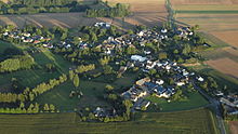
Metternich (Münstermaifeld)
|
Metternich
City of Münstermaifeld
Coordinates: 50 ° 14 '23 " N , 7 ° 22' 57" E
|
||
|---|---|---|
| Height : | 240 m above sea level NHN | |
| Area : | 7.32 km² | |
| Residents : | 223 (Aug 2014) | |
| Population density : | 30 inhabitants / km² | |
| Incorporation : | December 31, 1975 | |
| Postal code : | 56294 | |
| Area code : | 02605 | |
|
Location of Metternich in Rhineland-Palatinate |
||
Metternich is a district of Münstermaifeld in the Mayen-Koblenz district in Rhineland-Palatinate . Until it was incorporated on December 31, 1975, Metternich was an independent municipality.
Geographical location
Metternich is located in the southeast of the city of Münstermaifeld .
history
Metternich is first mentioned in 1187 in connection with the knights Albero and Hertwin de Mettrico. These had their property here, after which they were named. Around 1280 aristocratic and ecclesiastical dignitaries appear in the Metternich sources. So u. a. the knight Hermann von Loef. Münstermaifeld Abbey is also mentioned frequently. According to the fire book of 1563, the place consisted of 21 households. Until the end of the Old Kingdom he belonged to the Oberamt Münstermaifeld and was also parish to Münstermaifeld. The criminal jurisdiction was of the Haimburgen u. a. von Metternich exercised in the court on the Bubenheimer Berg. The mayor of the court was in Metternich. Around 1650, other estates / farms belonged to the Counts of Eltz, von Kleeberg and the Elector of Trier. In 1790 the Counts von der Leyen had a farm here.
These goods were all in the area of today's “In der Feils” street. At times this area was connected to the city of Münstermaifeld. In 1798, however, it was integrated by the French with most of the Schrumpftal and the rest of the Metternich area into the independent municipality of Metternich, which is now a district of Münstermaifeld.
politics
The Metternich district is one of five local districts that were formed by the main statute in Münstermaifeld. The election of a local advisory board is not planned.
Mayor is Uwe Gerd Krause.
Attractions
- Eifelstraße: handle pump, basalt basin
- (at) Eifelstraße 5: Schwengel Pump, Rheinböllener Hütte, end of the 19th century
- (at) Eifelstraße 10: wayside cross, marked 1668
- Eifelstraße 19: Hofreite; Quarry stone building, half-hip roof, marked 1833; Overall system
- Eifelstraße 29: Hofreite; Quarry stone building, 19th century; Overall system
- in the cemetery: wayside cross, marked 1682
- In the Feils: Wegekapelle, quarry stone, end of the 19th century
- (at) In der Feils 1: wayside cross, marked 1657; Door, marked 1756
- (at) In der Feils 2: wayside shrine, ladle shape, 16th or 17th century
- Catholic Chapel of St. Praxedis; Saalbau, marked 1765; Cemetery: grave crosses, 17th and 18th centuries
District
- on the K 42 towards Mörz: wayside cross, niche type, basalt, marked 1606
- on the L 113 towards Hatzenport: wayside cross, marked 1751
- north of Metternich towards Mörz: wayside cross, marked 1598
Web links
Individual evidence
- ↑ Citizens' Information Association Maifeld 2014/2015
- ↑ Official municipality directory (= State Statistical Office of Rhineland-Palatinate [Hrsg.]: Statistical volumes . Volume 407 ). Bad Ems February 2016, p. 172 (PDF; 2.8 MB).
- ↑ ed. P. Brommer, Mainz 2003, p. 180
- ^ Fabricius, Explanations, Map from 1789, p. 209
- ^ Fabricius, map from 1789, p. 526
- ^ City of Münstermaifeld: main statute. § 2 to July 4, 2019, accessed on January 25, 2020 .
- ^ City of Münstermaifeld: Mayor and Mayor. Retrieved January 25, 2020 .


