
Münk
| coat of arms | Germany map | |
|---|---|---|

|
Coordinates: 50 ° 18 ' N , 7 ° 3' E |
|
| Basic data | ||
| State : | Rhineland-Palatinate | |
| County : | Mayen-Koblenz | |
| Association municipality : | Vordereifel | |
| Height : | 480 m above sea level NHN | |
| Area : | 5.13 km 2 | |
| Residents: | 252 (Dec. 31, 2019) | |
| Population density : | 49 inhabitants per km 2 | |
| Postal code : | 56729 | |
| Area code : | 02656 | |
| License plate : | MYK, MY | |
| Community key : | 07 1 37 077 | |
| Association administration address: | Kelberger Strasse 26 56727 Mayen |
|
| Website : | ||
| Local Mayor : | Alfred Steffens | |
| Location of the local community Münk in the Mayen-Koblenz district | ||
 |
||

Münk is a municipality in the Mayen-Koblenz district in Rhineland-Palatinate . It belongs to the community of Vordereifel , which has its administrative headquarters in Mayen .
Geographical location
Münk is located west of Mayen in the Vulkaneifel . A considerable part of the demarcation consists of forest in community ownership. In the neighboring village of Boos , the double maar is being expanded into a tourist attraction. You can reach Münk either from Ditscheid or by turning off the B 410 between Boos and Nachtsheim .
Three small brooks, the Mimbach, the Eschbach and the Linderseifen, flow over the district. The Linderseifen flows into the Mimbach and the Mimbach and Eschbach flow into the Elz .
history
Münk is mentioned for the first time in 1347 as Munkebach in a feudal lapel of Gerhard von Ditscheid to Philipp and Theoderich von Virneburg. Other forms of name: 1583 Monnike , 1724 Munich , 1780 Münung . The place shared the fate of the County of Virneburg in the Old Kingdom (until 1794): after the Counts of Virneburg died out , it came to the Counts of Manderscheid-Schleiden and, in 1593, to the Counts of Löwenstein-Wertheim.
In 1808 the area of the village, which was then part of Mairie Virneburg, consisted of 88 hectares of arable land, 12 hectares of meadows and 131 hectares of woodland.
On July 5, 1922, a hurricane devastated the place. Hardly a house remained undamaged.
- Statistics on population development
In 1583 a report in Münk counted 25 subjects, in 1623 there were 25 families.
The further development of the population of Münk, the values from 1871 to 1987 are based on censuses:
|
|

politics
Municipal council
The council in Münk consists of six council members, who in the local elections on May 26, 2019 in a majority vote were elected, and the honorary mayor as chairman.
mayor
Alfred Steffens became local mayor of Münk in 2014. In the direct election on May 26, 2019, he was confirmed in his office for another five years with a share of the vote of 82.31%. Alfred Steffens' predecessor was Ferdinand Retterath, who held the office for 20 years.
coat of arms
|
|
Blazon : "Under a golden shield head with three red diamonds in bars, two silver stag poles in blue, in between a golden Latin cross."
The coat of arms, which has been in use since 1996, was designed by the heraldist Karl Becke. |
| Foundation of the coat of arms: While the diamonds in the upper part refer to the county of Virneburg , the lower part refers to the chapel patron St. Hubertus . |
Culture and sights
See also the list of cultural monuments in Münk
Hubertus Chapel
In 1758 a small chapel was built in honor of St. Hubertus. Nothing is known about a previous building from which the bell from 1748, which was removed in 1942, came. The new building, marked with the year 1888, was inaugurated on November 15, 1887. The parish was almost always a night home .
Village community
The cooperation in the village council is extremely good, the club life is lively. The largest club is the Hubertus Schützenbruderschaft, founded in 1956, with around 60 members. It organizes the Schützenfest on the 2nd Sunday in July and the village festival in the Schützenhalle in autumn - a "gem" for the mayor. The fair on the 1st Sunday of May, however, is currently being looked after by the bachelor club. The volunteer fire brigade and the Möhnen are also active.
There used to be seven wooden crosses on the outskirts around the village, to which people went to pray for the sick when they were seriously ill. In 2004 the village community erected the crosses again so that this custom would not be forgotten.
Economy and Infrastructure
economy
For the mayor Ferdinand Retterath, who has been in office since 1994, Münk is a “healthy residential community” in 2005 with the hope of being largely free of debts once the loans for the village community center have been paid off. The formerly purely agricultural village has - like many other places in the area - developed into a commuter community. Many work in Mayen, the mayor himself drives to Koblenz to work. Currently there are only two part-time farmers with livestock farming. By no means untypical for the area, the agricultural land is leased to two to three large farmers who cultivate land in around 15 communities. Many residents who were employed in road construction used to commute to Cologne or Bonn . The main employer was at times the local tool factory Elora (headquarters in Remscheid ), founded around 1957/58. Also to be mentioned is the cultivation of Christmas trees ( firs ) on their own property, which some citizens run (similar to e.g. in Boos).
Development prospects
Münk's capital is the intact nature of the Eifel. Whoever decides to live here, says the mayor, chooses the landscape. In 2004/05, several kilometers of hiking trails were expanded as part of the land consolidation. Since, unlike in neighboring Boos, there is no tourist infrastructure - Münk has neither a shop nor an inn - tourism only plays a very minor role. However, guests stay in the guest rooms when races are taking place on the nearby Nürburgring .
school
The village school existed until 1965, today the children have to go to school in Boos ( elementary school ) or Nachtsheim ( secondary school plus ). The school building, built in 1895, now serves as a village community center (inaugurated in 1995). In 1963, three children from Münk switched to a higher school for the first time.
Trivia
Just as the people of Nachtsheim used to be raised as straw men and the Boosers as oxen, there was also a place name for the people of Münker : Münker Mücken - presumably because of the place name.
photos

Eifel landscape near Münk, view of the neighboring town of Lind
Chapel of St. Hubertus from 1888

Inside of the chapel

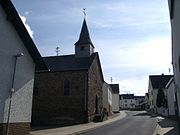
Town view, approach from Boos


literature
- History of the local parishes of the Mayen-Land community.
- Part 1: Churches, chapels, parishes. Mayen o. J. [2000], pp. 237-242 (Kapelle) ISBN 3-9807436-0-8
- Part 2: schools. Mayen 2003, pp. 321–326 (school)
Web links
- Internet presence of the local community Münk
- Local community Münk on the website of the association community Vordereifel
- Literature about Münk in the Rhineland-Palatinate State Bibliography
Individual evidence
- Interview with the local mayor Ferdinand Retterath on August 13, 2005 and documents made available by him
- ↑ State Statistical Office of Rhineland-Palatinate - population status 2019, districts, communities, association communities ( help on this ).
- ↑ a b c d e Karl-Heinz Schmitz, Ferdinand Retterath: Chronicle of the local community Münk - Small historical outline. Local community Münk, accessed on February 15, 2020 .
- ↑ State Statistical Office Rhineland-Palatinate - regional data
- ^ The Regional Returning Officer Rhineland-Palatinate: Local elections 2019, city and municipal council elections
- ^ The Regional Returning Officer Rhineland-Palatinate: direct elections 2019. see Vordereifel, Verbandsgemeinde, 20th line of results. Retrieved February 15, 2020 .
- ^ The Regional Returning Officer Rhineland-Palatinate: Election of the honorary local and city mayors. Mayen-Koblenz district 2014 ff. Retrieved on February 15, 2020 .

Eight | Alkene | Andernach | Look | Arft | Baar | Bassenheim | Bell | Bendorf | Bermel | Boos | Brey | Brodenbach | Castles | Thieving | Ditscheid | Agree | Ettringen | Gappenach | Low | Gierschnach | Hatzenport | Hausten | Herresbach | Shepherds | Cold | Kaltenengers | Sweeping | Notches | Chained | Kirchwald | Kobern-Gondorf | Kollig | Kottenheim | Kretz | Kruft | Langenfeld | Langscheid | Clay | Lind | Löf | Lonnig | Luxem | Quirks | Mayen | Mendig | Mertloch | Monreal | Mülheim-Kärlich | Münk | Münstermaifeld | Night home | Naunheim | Nickenich | Niederfell | Niederwerth | Nörtershausen | Upper skin | Notice | Pillig | Plaidt | Polch | Reudelsterz | Rhens | Vineyards | Over | Saffy | Sankt Johann | Saint Sebastian | Siebenbach | Spay | Door | Trimbs | Urbar | Urmitz | Vallendar | Virneburg | People's field | Waldesch | Hamlet | Weißenthurm | Weitersburg | Welling | Welschenbach | Wierschem | Winningen | Clouds