Laacher See
| Laacher See | ||
|---|---|---|

|
||
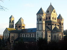
| Laacher See with Maria Laach Benedictine Abbey | ||
| Geographical location | Vulkaneifel , Rhineland-Palatinate | |
| Tributaries | Springs in the lake | |
| Drain | Delius tunnel with 0.050 m³ / s | |
| Islands | no | |
| Location close to the shore | Mendig , Andernach , Mayen , Neuwied , Koblenz , Bad Neuenahr-Ahrweiler | |
| Data | ||
| Coordinates | 50 ° 24 '37 " N , 7 ° 16' 11" E | |
|
|
||
| Altitude above sea level | 275 m above sea level NHN | |
| surface | 3.31 km² | |
| length | 1,964 km | |
| width | 1.186 km | |
| volume | 0.103 km³ | |
| scope | 7.3 km | |
| Maximum depth | 51 m | |
| Middle deep | 31 m | |
| Catchment area | 12.2 km² | |
|
particularities |
||
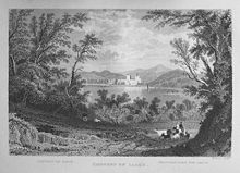
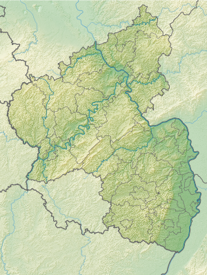
The Laacher See is located in the Vulkaneifel near the Maria Laach Abbey . This caldera lake is the largest lake in Rhineland-Palatinate . Like the Maria Laach Abbey, it belongs to the local community of Glees . The Laacher volcano broke last about 10,930 v. Chr. From. Volcanic activity can still be found today in the form of outgassing.
etymology
The word Laach , related to our current word Lache , comes from the Old High German lacha (related to Latin . Lacus , -ūs m. - See and English. Lake - lake), which later became too laach and means lake . The name Laacher See is thus a tautology . Laach has also passed on to the name of the place and monastery. The latter was only renamed Maria Laach by the Jesuits in 1863 .
features
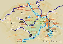
The oval lake is approximately 3.3 square kilometers the largest lake in Rhineland-Palatinate and is located in the front eifel (Osteifelvulkangebiet) near the towns Andernach (8 km), Bonn (37 km), Koblenz (24 km) and Mayen (11 km) north of Mendig (motorway junction of the A 61 , 3 km).
The lake is completely surrounded by an average 125 m high wall and has a depth of 51 m. It is mainly fed by groundwater and has no natural runoff. Today in 275 m above sea level. The water surface at sea level used to fluctuate by 15 m, which made agriculture difficult. According to Klaus Grewe , the 880 m long tunnel was built to the south in the Middle Ages during the term of office of Abbot Fulbert (1152 to 1177) to protect the monastery from flooding ( Fulbert tunnel ). Between 1840 and 1845 the Delius and von Ammon families (then owners of the secularized monastery and lake) built a parallel tunnel about 5 m lower to lower the water level to today's level in order to gain land and pasture. The lake lost about a third of its water surface through both drainage tunnels.
Geology and volcanic activities


Although the Laacher See is often referred to as "the largest maar in the Vulkaneifel ", geologically speaking it is neither a maar nor a crater lake , but a water-filled caldera - a more or less circular basin, which is caused by the sagging of the ceiling of the emptied magma chamber below the Volcano was formed. Over time, such a kettle can fill with water. The Laacher See is in the Eifel, next to the neighboring Wehrer Kessel , the largest caldera and the only water-filled caldera in Central Europe.
The last eruption of the volcano that created this caldera took place around 10,930 BC. Instead of. It lasted only a few days and consisted of a main Plinian phase , which was initiated and ended by phreatomagmatic explosions .
Huge amounts of volcanic ash and pumice were thrown out, which covered the area up to seven meters thick as far as the Rhine Valley . The ejected material clogged the valley of the Rhine at the Andernacher Pforte , and the lake that was dammed up as a result extended over the Neuwied basin to the Upper Rhine. The tidal wave after the dam broke poured over large areas of the Lower Rhine. The sulfur-rich Laacher See eruption is discussed as the trigger for the climate anomaly of the younger Dryas glaciation .
The total amount ejected was about 6 km³ trunk magma volume, corresponding to about 16 km³ of loose volcanic matter ( tephra ), which corresponds to a value of 6 on the scale of the volcanic explosion index ranging from 0 to 8 . This made the eruption one and a half times as strong as that of Pinatubo in 1991 or six times as strong as the eruption of Mount St. Helens in 1980 . The finer deposits of the ash clouds can still be found in Quaternary sediments as a narrow pumice horizon, transported to Sweden and northern Italy . The formation was named Laacher See Tephra ( LST ) by Bogaard and Schmincke in 1984 . Geoscientists and archaeologists use it as a proxy for dating or supra-regionally as a guiding horizon for Allerød .
Rising carbon dioxide in the south-eastern shore zone of the lake (so-called mofettes ) still shows the volcanic activity of the region ( volcano park ) today . Volcanologists and geologists assume that there is currently no acute danger from the Laacher See. Against the background of the long volcanic activity in the Eifel, however, the possibility of a volcanic eruption cannot be denied, although this does not have to be the case in the Laacher See area. At least 17,000 years passed between the first appearance of magma under the Laacher See and its massive eruption at the end of the last Ice Age. Measured against these long periods of time, a new eruption of the volcano within the next millennia is “very likely”. In the entire Eastern Eifel there has been a volcanic eruption on average every five to ten thousand years over the last 450,000 years, a period that has clearly been exceeded since the last eruption.
The latest developments (including local earthquakes in 2018) show a slight, slowly increasing activity. Experts continue to monitor the development of the volcano and have found that the magma chamber is still intact. The time to the next outbreak can be hundreds of years, or it can be sudden and unexpected. The rising carbon dioxide is still present.
A study published in January 2019 found eight sequences of low-frequency earthquakes in a total of four spatially limited clusters at a depth of between 10 and 45 kilometers since 2013. Scientists interpret this as confirmation of the prevailing view that the volcano is still active and that the magma chamber is currently filling with the rise of magma from the upper mantle. However, these are not yet any signs of imminent volcanic activity. It is currently assumed that after an eruption it will take around 30,000 years for the lava chamber under the Eifel to be filled again.
The most recent activity in the region was a swarm quake on October 28, 2019 at 11:17 p.m. with the epicenter of the earthquake in the Andernach district of Namedy, approx. 4 km from Lake Laacher See. The swarm quake consisted of at least six individual quakes with a maximum magnitude of 1.6. The swarm showed no deep-low-frequency characteristics ; therefore it cannot be directly assigned to magmatic processes.
Nature reserve
The lake and its surroundings were declared a nature reserve Laacher See on June 26, 1935 - because of the geological and morphological nature (unique example of postglacial volcanism in the Eifel), for natural history reasons, as a habitat for rare endangered plant and bird species as well because of its particular scenic beauty and uniqueness.
See also: List of nature reserves in the Ahrweiler district
fauna
Mussel crabs
The mussel crabs ( ostracods ) living in the water of the lake and the fossil shells of these small crustaceans that have survived in the lake sediments were examined in detail.
Molluscs
In a special publication the mussels and snails grouped under the term mollusks were treated.
Economy and tourism
The Laachersee among the possessions of the nearby Benedictine - Abbey Maria Laach , as well as the surrounding lands, a fishing operation and the Seehotel Maria Laach . It is used as a recreational area for swimming, sailing, hiking and camping. The sailing club “Laacher See” Mayen (SCLM) and the Surf-Club Laacher See e. V. use the lake itself, the running community Laacher See its banks and the surrounding area as a territory. The “ Laacher See ” campsite and a mini golf course are also located on the lake . The Laacher Center for Natural History and Microscopy , which dealt with the natural history of the Laacher See and its surroundings (closed permanently since 2014), was located near the abbey . In addition, the Naturfreundehaus Laacherseehaus is located on the road towards Mendig .
The German volcano museum Lava-Dome is located in Mendig . It is the central attraction of the volcanic park , which stretches across the entire Eastern Eifel with its over twenty sights. The Laacher See also belongs to the National Geopark Laacher See .
Plane wreck
The wreck of a British four-engine Halifax bomber from the Second World War has been on the lake bed in the western part of the lake since August 29, 1942, and there may be another wreck near the boat rental near the shore. It could still be seen until the first post-war years, when it slipped further down. On April 27, 2007, the abbey announced that until further notice, due to the risk of explosion of any bombs with long-term detonators, the Brohltal community, Niederzissen, issued an order of March 30, 2007, and that no permit for diving, boat traffic, swimming or hobby fishing will be granted in this area. From June 2 to 20, 2008, a diving campaign took place under the leadership of the group of divers from the Rhineland-Palatinate ordnance disposal service to investigate possible dangers. Individual fragments of the machine were recovered, but the wreck itself or bombs were not found. The dives took place under very difficult visibility conditions (darkness, suspended matter). It therefore remains unclear whether there are bombs in the aircraft wreck or in its vicinity. It cannot be ruled out that there may still be residues of hydraulic oil and fuel in the wreck (according to eyewitness reports, the machine fell on fire into the lake).
The saga of the sunken castle
Old legends tell of a castle that is said to have stood on an island in the Laacher See. In it lived a count who treated his subordinates tyrannically. One day the island, including the castle and the malicious count, sank into the lake after an apocalyptic storm. The legend inspired Friedrich Schlegel to write his poem Das versunkne Schloß .
See also
- List of lakes in Rhineland-Palatinate
- List of lakes in Germany
- List of volcanoes in Germany
- Volcano (film)
literature
- Rudolf Blenke: The Laacher See and its volcanic surroundings. (School font). Strüder, Neuwied 1879 ( digitized version ).
- Paul van den Bogaard: The eruption of the Laacher See volcano . Dissertation, University of Bochum 1983
- Werner P. D'hein : Vulkanland Eifel. Nature and culture guide, with 26 stations on the "German Volcano Road" . Gaasterland-Verlag, Düsseldorf 2006, ISBN 3-935873-15-8 , ISBN 978-3-935873-15-4 .
- Wilhelm Meyer: Geology of the Eifel . 3rd supplementary edition. E. Schweizerbart'sche Verlagbuchhandlung, Stuttgart 1998, ISBN 978-3-510-65161-0 .
- Joseph Overath: Shaping church history around the Laacher See , Patrimonium-Verlag , Aachen 2017, ISBN 978-3-86417-095-9 .
- Hans-Ulrich Schmincke : Volcanoes of the Eifel: Structure, origin and today's importance. Springer / Spektrum Verlag, 2nd ext. u. revised 2014 edition, ISBN 978-3-8274-2984-1 .
- Karl Otto Jakob Ewich : The leader at the Laacher-See u. through the Brohlthal. Printed and published by CW Lichtfers, Neuwied 1852 ( Google Books ).
- Johann Jakob Ewich : The lake of Laach. A poetic description, along with an encore. Publisher Johann Jakob Ewich, Duisburg 1857.
- Ferdinand Hey'l: On volcanic soil . In: The Gazebo . Issue 11, 1878, pp. 178-181 ( full text [ Wikisource ]).
Web links
- The creation of the Laacher See. In: Lava-dome.de. Retrieved August 23, 2020 .
- Brigitte Nixdorf, Mike Hemm, Anja Hoffmann, Peggy Richter: North Rhine-Westphalia, Rhineland-Palatinate and Saarland (= TU Cottbus [Hrsg.]: Documentation of the condition and development of the most important lakes in Germany . Part 9). ( online [PDF; 562 kB ]).
- Apocalypse in the Rhine Valley . In: Spectrum of Science . February 2009 ( online [PDF; 1.8 MB ]).
- Evolution of Complex Plinian Eruptions: the Late Quarternary Laacher See Case History. ( Memento of August 6, 2012 in the Internet Archive ).
- Eifel volcanoes: magma chamber probably still active. ( Memento of November 2, 2011 in the Internet Archive ). In: Sinexx.
- The eruption of the Laacher See volcano. 1983(dissertation by Paul van den Bogaard).
- Martin Hensch, et al .: Deep low-frequency earthquakes reveal ongoing magmatic recharge beneath Laacher See Volcano (Eifel, Germany) . In: Geophysical Journal International . No. 216, 2025–2036 , 2019, doi : 10.1093 / gji / ggy532 (English, researchgate.net ).
- Michael W. Förster, Frank Sirocko: Volcanic activity in the Eifel during the last 500,000 years: The ELSA-Tephra-Stack. (PDF) In: Global and Planetary Change. 2016 (English).
Individual evidence
- ^ A b Thomas Litt, Karl-Ernst Behre, Klaus-Dieter Meyer, Hans-Jürgen Stephan and Stefan Wansa: Ice Age and the Present . Stratigraphic terms for the Quaternary of the northern German glaciation area. In: Quaternary Science Journal . No. 56 (1/2) , 2007, ISSN 0424-7116 , p. 7-65 , doi : 10.3285 / eg.56.1-2.02 ( publiss.net ). Ice Age and the Present ( Memento from February 5, 2015 in the Internet Archive )
- ↑ a b Burkhard Scharf, Ulrich Menn: Orographic, hydrological data of the Laacher See . In: Limnology of Eifel maar lakes . GKSS Research Center, Geesthacht 1992, p. 44-62 (English: Hydrology and morphometry .).
- ↑ Klaus Grewe: The Fulbert tunnel on the Laacher See. An engineering achievement of the high Middle Ages. Magazine Arch. Mittelalter 7, 1979, 107-142.
- ↑ Michael Baales, Olaf Jöris, Martin Street: Impact of the Late Glacial Eruption of the Laacher See Volcano, Central Rhineland, Germany. In: Quaternary Research 58, 2002, pp. 273-288, doi: 10.1006 / qres.2002.2379 .
- ↑ Michael Baales, Olaf Jöris: Change of climate and environment on the Middle Rhine and Moselle towards the end of the last ice age. In: Reports on archeology on the Middle Rhine and Moselle , 10, 2005, pp. 9–43.
- ↑ James UL Baldini, Richard J. Brown, and Natasha Mawdsley: Evaluating the link between the sulfur-rich Laacher See volcanic eruption and the Younger Dryas climate anomaly. (PDF; 3.7 MB) In: Climate of the Past. July 4, 2018, accessed January 9, 2019 .
- ↑ Claudia Köhler: Gravimetric investigations on the southern edge of the Laacher See to dissolve the underground structure in the edge area of the volcano ( Memento from June 16, 2012 in the Internet Archive ). Technical University Bergakademie Freiberg, 2005, Institute for Geology (PDF, diploma thesis).
- ↑ M. Weidenfeller: Laacher See Tephra Formation . ( Memento of March 4, 2016 in the Internet Archive ) In: Lithostratigraphisches Lexikon , last corrected July 6, 2009, accessed on September 21, 2015.
- ^ Horst Rademacher: Laacher See. Eifel volcanoes still active. In: Frankfurter Allgemeine . October 30, 2010, accessed October 22, 2014 .
- ↑ Christoph von Eichhorn: Magma chamber under volcanic lake fills up. In: Süddeutsche Zeitung. January 9, 2019, accessed January 9, 2019 .
- ↑ Martin Hensch, Torsten Dahm, Joachim Ritter, Sebastian Heimann, Bernd Schmidt, Stefan Stange, Klaus Lehmann: Deep low-frequency earthquakes reveal ongoing magmatic recharge beneath Laacher See Volcano (Eifel, Germany). In: Geophysical Journal International 523, 2019, doi: 10.1093 / gji / ggy532
- ↑ Unusually deep earthquakes indicate movements of magmatic fluids under the Laacher See. In: Communication from the State Office for Geology and Mining Rhineland-Palatinate. January 9, 2019, accessed January 11, 2019 .
- ↑ Jens Skapski: Small swarm of earthquakes in Andernach. In: Juski's earthquake news. October 29, 2019. Retrieved October 29, 2019 .
- ↑ Earthquake in the Middle Rhine Valley / In Andernach the earth shook during the night. General-Anzeiger (Bonn), accessed on October 29, 2019 .
- ↑ Eugen Karl Kempf, Burkhard Wilhelm Scharf: Living and fossil shell shrimp (Crustacea: Ostracoda) from the Laacher See . Communications from Pollichia, 68 (1980) 205-236, Bad Dürkheim 1981.
- ↑ Hans Miegel: The Laacher See and its mollusks . Decheniana , 116 (1963) 45-56, Bonn 1964.
- ↑ Hartmut Wagner: British wreck close to the shore of the Laacher See. Location of the bomber known for a long time. In: Rhein-Zeitung. March 31, 2007, accessed October 22, 2014 .
- ↑ British bomber with ammunition suspected in Laacher See. In: General-Anzeiger (Bonn). March 29, 2007, accessed September 11, 2017 .
- ↑ Günther section: high Hazardous ammunition Laachersee . In: General-Anzeiger (Bonn). March 30, 2007, accessed September 11, 2017.
- ↑ Stefanie Mittenzwei: British bomber in the Laacher See. Report of the ordnance clearance service Rhineland-Palatinate on the results of the diving action from June 2 to 20, 2008. (No longer available online.) Ministry for the Environment, Agriculture, Food, Viticulture and Forests of the State of Rhineland-Palatinate, July 11, 2008, archived from the original on May 12, 2014 ; Retrieved May 21, 2013 .
- ^ Heinrich Pröhle : Legend of the Rauschenmühle and the Laach Castle . In: Rhineland's most beautiful sagas and stories . 1886, p. 137–142 ( Sage zeno.org [accessed October 22, 2014]).
- ^ Paul Weitershagen: Eifel and Mosel tell - sagas and legends , Cologne 1968, 3rd edition 1982, ISBN 978-3-7743-0199-3 .
- ^ Schlegel's poem from the Freiburg anthology of ub.uni-freiburg.de


