
Mount St. Helens eruption in 1980


The 1980 eruption of Mount St. Helens was one of the most powerful volcanic eruptions of the 20th century. At shallow depths of the south of the US state of Washington located, most recently as active in the 15th century volcano make Mount St. Helens was for about two months before the recent outbreak again magma ascended. The north side of the mountain was bulged and cracked. For the time being, there was a series of earthquakes and explosive steam escapes. On May 18, 1980, as a result of such an earthquake at 8:32 a.m. (all times are given as local times in Pacific time ), the entire north flank slid like an avalanche . As a result, the magma, which had been enriched with gas and compressed steam, was suddenly exposed to a greatly reduced ambient pressure. The result was the release of a pyroclastic current , a mixture of gas-rich, liquid magma that moved rapidly towards nearby Spirit Lake , quickly overtaking the debris avalanche and causing devastating damage to the area. With 1.2 cubic kilometers of ejected material and a value of 5 on the volcanic explosion index , this eruption was larger and more violent than that of Lassen Peak in California in 1915. It reached the eruption of Novarupta in Alaska in 1912, the strongest eruption ever recorded in the United States but not approach.
The resulting in the onset and high in the atmosphere up higher Plinian column distributed volcanic ash over eleven US states. At the same time, snow, ice, and even entire glaciers melted on the mountain, triggering volcanic mud flows - called lahars - that reached into the Columbia River , 50 kilometers away . The eruptions that followed were far less powerful, but other larger eruptions occurred during the year. Although a safety zone had previously been established around the volcano, 57 people and thousands of animals died in the eruption of May 18, and ashes and lahars turned hundreds of square kilometers into wasteland. The total damage was more than a billion US dollars.
The eruption of Mount St. Helens was and is of great importance for volcanology : it occurred in an easily accessible area and in a country that had sufficient financial means and scientific resources to detect the volcano after the first signs of volcanic activity let a team of qualified scientists observe and analyze them. The eruption of Mount St. Helens is therefore one of the best-researched eruptions of a volcano.
Prehistory of the volcanic eruption
The first earthquakes - harbingers of the coming eruptions

On March 16, 1980, a series of weak earthquakes occurred in the Mount St. Helens area. Scientists already interpreted this series of earthquakes as a sign that magma movements had occurred below Mount St. Helens. On March 20 at 3:47 a.m., a weak earthquake measuring 4.2 on the Richter scale , the epicenter of which was below the northern flank of Mount St. Helens, confirmed this initial suspicion. For the next few days, the seismographs monitoring the area were literally oversaturated by a gradually accelerating wave of earthquakes.
Around noon on March 25, the wave of earthquakes reached its first peak: In the following two days, 174 tremors of magnitude 2.6 or greater were measured. In the period up to May 18, stronger tremors of 3.2 and more were measured on the Richter scale. While the number of quakes with a magnitude of at least 4.0 was around five per day at the beginning of April, this increased slowly to eight daily quakes one week before the eruption of the volcano. Initially there were no signs of an impending eruption, but the quakes repeatedly triggered ice and snow avalanches .
The first eruptions

On March 27 at 12:36 p.m., one or two almost simultaneous phreatic eruptions (explosive steam escapes from the groundwater) threw ash and debris from inside the summit crater and created a new crater about 76 meters in diameter in addition to an approximately 1,800 meter high ash column. At the same time, a network of cracks about 4900 meters long and running to the east formed in the summit area. Further earth shock waves and a series of steam explosions hurled volcanic ash between 3,050 and 3,350 meters high above the crater. Most of this ashes fell within a radius of five to 19 kilometers; however, individual rainfall was recorded 150 miles south in Bend , Oregon, and 150 miles east in Spokane , Washington. Due to the flooding threatened by snowmelt and the landslides triggered by tremors, a safety zone was set up within a radius of around 25 kilometers around the volcano from March 27th. The people living in this area have been evacuated.
On March 29, a second new crater and a blue flame - probably caused by burning gases - were observed dancing back and forth between the two craters. Ash clouds rolling downhill generated static electricity that triggered lightning bolts up to three kilometers long. As of March 30, 93 different minor outbreaks were reported. After rhythmic tremors had worried the observing geologists on April 3, the governor of Washington state Dixy Lee Ray declared a state of emergency on April 3. This restricted access to an area of 13 kilometers around the volcano. Only the lodge manager Harry R. Truman refused to be evacuated and stayed in the restricted area. He briefly aroused great media interest, but died in the outbreak.
The bulge on the north flank

On April 8, both craters formed a joint 520 by 260 meter basin. A team from the US Geological Survey (USGS) found in the last week of April that a 2.4-kilometer section of the north side of Mount St. Helens was displaced by about 82 meters - a bulge that increased by one and a half to one and a half a day until early May It expanded 1.8 meters and expanded to more than 120 meters in mid-May. While this bulge shifted northward, the rest of the summit region gradually sank and formed a geological " trench ". The geologists observing the volcano came to the conclusion on April 30th that this bulge posed the greatest danger. Breaking off the rest of the rock would not only mean a huge landslide, but also likely be accompanied by a large volcanic eruption. Something similar happened in 1956 on the Russian peninsula of Kamchatka : On March 30, 1956, an unstable flank of the Besymjanny volcano broke off and triggered a horizontally directed explosion that blasted away the top of the mountain and created a crater 1.9 kilometers in diameter let. A radius of 34 kilometers was devastated by almost four cubic kilometers of smoking ash and debris.
The volume of the mountain increased by 125 million cubic meters by mid-May. This probably corresponded to the volume of magma that flowed into the volcano. Such a volcanic shape is known as a cryptodome because of the magma hidden beneath the surface , while an “open” volcano forms a lava dome .

On May 7th, more eruptions followed, similar to those in March and April. The bulge on the north flank continued to grow over the next few days. Before May 18, a total of about 10,000 tremors were recorded, the epicentres of which were concentrated in a small area less than 2.6 kilometers in diameter below the northern flank of Mount St. Helens. The visible eruptions ended on May 16, causing the previously intense media interest to wane. Increasing public pressure caused the authorities to allow a limited number of people access to the restricted area on May 17 so that they could retrieve at least some of their belongings. Another such access was planned for May 18 at 10 a.m.
At the same time, an amount of dacite magma, later estimated to be 110 million cubic meters, had risen in the interior of the mountain. The rising magma expanded the northern flank of Mount St. Helens to approximately 150 meters and heated the groundwater stored in the mountain, causing countless phreatic eruptions.
Slipping of the north flank


At 7 a.m. local time on May 18, USGS volcanologist David A. Johnston , who had taken over the Saturday night shift at the observation post about ten kilometers north of the mountain, reported the results of some laser measurements that he had carried out shortly before would have. The activities of Mount St. Helens showed no changes from the previous days. Neither the rate at which the bulge on the north flank increased, nor the sulfur dioxide emissions or the ground temperatures, showed any unusual changes that indicated the great explosion that was to occur a short time later.
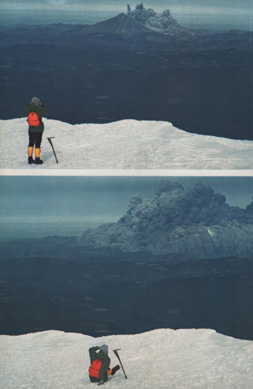
At 8:32 a.m., an earthquake with a magnitude of 5.1 struck directly below the north side of the mountain without warning. About seven to 20 seconds after this tremor - ten seconds being the probable range - the entire northern flank detached itself from Mount St. Helens in one of the largest landslides ever recorded. The first to say “Vancouver! Vancouver! This is it! ” Reported the outbreak was Johnston. There are only five known photos or photo series that record the landslide and the beginning of the eruption:
- Keith Ronnholm, who studied geophysics at the University of Washington , the amateur photographer Gary Rosenquist and a few other friends camped on a hill near Forest Road 100 at Bear Meadow - about 17.6 kilometers northeast of the volcano . Rosenquist had set up a camera with a tripod to watch the mountain. He missed the first ten seconds of the slide, but then reached the camera. It was aimed at the summit region of the mountain in anticipation of a vertical eruption. In the hustle and bustle, he accidentally tore it down, which, however, appropriately placed the debris avalanche and the eruption cloud exactly in the center of the picture. Keith Ronnholm also got recordings. To this day, the photo series are the best-known images of the outbreak. Then all campers managed to escape north through the ash rain with their cars.
- A group of climbers happened to be on the summit of Mount Adams , 33 miles to the east , when Mount St. Helens erupted. Due to their exposed position and the great distance, they were able to follow the eruption cloud over its entire length. The photos show, among others, group member Suzanne Christensen, who stares in disbelief at the eruption and falls down in shock.
- The then 30-year-old Robert Rogers from Portland took photos on a nearby ridge 12.2 kilometers west of the volcano. Ty Kearney also managed a series of photos at the same location.
- The photographer Robert E. Landsburg (* 1931) from Portland took photos from a similar position as Rogers, but was a little closer to the mountain in the direction of the lateral eruption. About 7.2 kilometers from the volcano, near the South Fork Toutle River, he photographed the eruption. As the glowing avalanche approached, he wound the film back into the film canister, put it in his backpack and placed himself on top of his luggage to protect the film. He died and was found 17 days later. The photo sequence could still be developed and provided volcanologists with important information.
- The geologist couple Keith and Dorothy Stoffel worked for the Washington Department of Natural Resources. At the time of the eruption, they were both on an observation flight in a Cessna directly over the summit. In this way, the Stoffels get recordings "from above".
The moving flank slid over the western foothills of Spirit Lake at a speed of 175 to 250 kilometers per hour. Part of the landslide hit a 350 meter high rock ridge nine and a half kilometers north. A small portion of the landslide flowed over the ridge, but most of it was deflected by the ridge and diverted west into the river valley of the North Fork Toutle River . It was buried with rubble over a length of 21 kilometers up to 180 meters high. In total, the 2.9 cubic kilometers of debris that the landslide loosened covered an area of 62 square kilometers.
Most of the former northern flank of the mountain became a scree field 27 kilometers long and a mean 47 meters high. About 1.6 kilometers below Spirit Lake, the debris reached its greatest height, the shallowest was the burial on the western edges. The landslide temporarily displaced all the water in Spirit Lake, creating waves 180 meters high. When the water flowed back into the lake, the bottom of which had been raised by 60 meters due to the rubble, it swept away thousands of trees that had felled by the pyroclastic flow that followed the landslide.
Pyroclastic currents
Initial lateral explosion

After the northern flank of Mount St. Helens slipped with the massive landslide, the Dacite magma inside the mountain was exposed to a drastically reduced ambient pressure. As a result, the gas-saturated, partially melted rock - as well as the high-pressure steam above it - exploded a few seconds later. The explosion pushed through the last foothills of the landslide and hurled the rock northward. The resulting pyroclastic flow in the form of a dark gray cloud made up of overheated volcanic gases, ash and pumice from new lava and pulverized old rock stayed close to the earth's surface. It initially spread at a speed of around 350 kilometers per hour, but this quickly increased to around 1080 kilometers per hour. It is possible that the speed of propagation of the pyroclastic current briefly broke the sound barrier .
The pyroclastic current overtook the debris avalanche, widened and devastated a fan-shaped area 37 kilometers wide and 30 kilometers long in the form of a pressure wave. In total, around 600 square kilometers of forest were destroyed in an interior area of 13 kilometers in diameter. The heat also destroyed trees outside the zone affected by the pressure wave. While the outbreak of the pyroclastic current on the outbreak channel itself lasted little more than 30 seconds, it expanded northward for about another minute.

From Coldwater Ridge, about ten kilometers to the north, where volcanologist Johnston was posted, the explosion carried the soil down to the bedrock and swept trees with a trunk diameter of two meters. The volcanologist's body was never found.
Superheated matter from the pyroclastic flow evaporated water from Spirit Lake and the North Fork Toutle River, creating a secondary explosion that could be heard as far as British Columbia , Montana , Idaho, and northern California . Nevertheless, this explosion was not noticeable in many - much closer - areas such as Portland , Oregon, about 80 kilometers away . This so-called “ zone of silence ” expanded a few kilometers radially from the volcano and was created by the complex interplay between the sound waves of the eruption and the different movements and temperatures of the atmospheric air layers. The topography played an - albeit minor - role.
Consequences of the lateral pressure wave
In the zone of silence, however, the ash cloud emitted from the north side of Mount St. Helens could be observed. The pressure wave, which moved almost at the speed of sound and was enriched with volcanic debris, caused extensive damage up to 30 kilometers from the volcano. The affected area can be roughly divided into three concentric zones:

- The direct explosion zone , the innermost area within an average of about 13 kilometers around Mount St. Helens. Almost everything - natural or artificial - in this zone has been swept away and destroyed. For this reason, the zone is also known as the “tree-removal zone” . In this area the pyroclastic flow was not deflected by topographical conditions.
- The canalized explosion zone , the central area at a distance of up to 30 kilometers from the volcano. Here the current leveled every obstacle in its way and to a certain extent was bundled by topographical conditions. The force of the pressure wave is impressively demonstrated by large trees, which, like blades of grass, bent under a sickle on their trunk and lie exactly parallel. This zone is also called the "tree-down zone" .
- The burned zone , also known as the “ standing-dead zone” , is the edge of the affected area - an area in which trees are no longer knocked over by the pressure wave, but by the hot gases charred from the explosion.
Later research suggests that approximately 188 million cubic meters of the flow was made up of new lava and the remainder of older fragmented rock.
The victims of the outbreak

Overall, a wedge-shaped area 20 kilometers wide and 32 kilometers long was devastated by the pressure wave. When the pyroclastic current hit the first humans, it was still around 360 degrees Celsius and enriched with asphyxiating gases and sharp-edged objects. In addition to the volcanologist David A. Johnston, another 64 people - including lumberjacks , campers and hikers - stayed in the devastation zone . Including Johnston, 57 of them died.
As in the Johnston case, no bodies were found of 22 other people killed in the outbreak. Autopsies on the bodies found showed that most of them had suffocated on a plug of slime and volcanic dust after inhaling the fine ash. Had they not suffocated, the burns would have resulted in death. Examples of the people who died during the outbreak are four woodcutters who stayed 19 kilometers from the summit and went about their work there. They heard the thunder of the pyroclastic wave coming through the forest towards them. When it reached the men, they were thrown to the ground and wrapped in scorching heat and darkness. The burns they sustained affected between a third and half of the surface of their skin. One of the loggers died on the spot. Two of the loggers died in the hospital in the following days because the damage to the lungs was so severe that they failed. The fourth woodcutter survived thanks to multiple skin grafts.
Later pyroclastic currents

From the breakthrough left by the landslide, primarily new igneous rock flowed out. The resulting deposits formed a fan-shaped pattern consisting of piled-up surfaces, tongues and lobes.
The first pyroclastic current was followed by seventeen more currents on May 18, but no longer reached the destructive power of the first. Their direction of propagation corresponded to that of the first pyroclastic current.
The material deposited by the pyroclastic flows was still between 300 and 420 degrees Celsius two weeks later. Secondary steam eruptions from this heat created craters on the northern edge of the deposits, on the southern bank of Spirit Lake, and along the upper part of the North Fork Toutle River. These explosions continued sporadically for weeks and months after May 18. At least one eruption occurred about a year later, on May 16, 1981.
The ash column

While the debris avalanche and the initial pyroclastic flow were still spreading, an ash column ( Plinian column ) grew above the volcano, which reached a height of 19 kilometers within ten minutes and pyroclastics (solids from the interior of the earth) for a period of ten hours ) into the stratosphere . Near the volcano, the swirling ash particles created lightning bolts from static electricity, which in turn caused forest fires. During this time, parts of the now mushroom-shaped ash cloud collapsed and sent more pyroclastic currents along the flanks of Mount St. Helens. Later currents came directly from the new north-facing crater and consisted of glowing pumice stone and very hot pumice ash. Some of these streams evaporated ice and water, creating craters up to 20 meters in diameter, catapulting ash to heights of up to two kilometers (6,500 feet ).

Strong high-altitude winds carried a large part of the ash with an average speed of 100 kilometers per hour east-northeast of the volcano. At 9:45 a.m., the first ash shower reached Yakima in Washington State - a place 145 kilometers from the volcano. A total of 100 to 130 millimeters of ash fell on Yakima and in an area that reached as far as Spokane , visibility was only three meters at lunchtime. At 10:15 p.m. the first ash rain came down in the western part of Yellowstone National Park . In Denver , Colorado , the first ash rain was reported the next day. Over the next few days, ash rain was also reported from areas as far away as Minnesota and Oklahoma . Some of the ashes were driven around the whole earth for two weeks by the high winds.

During the nine hours of the most violent volcanic activity, about 540 million tons of volcanic ash were distributed over an area of more than 60,000 square kilometers. The maximum volume of the ash cloud before it was compressed by the onset of rainfall was around 1.3 billion cubic meters - which corresponds to around 208 million cubic meters of massive rock or seven percent of the landslide. On May 18, at around 5:30 p.m., the column of ashes collapsed, but smaller eruptions continued throughout the night and the following days.
Streams of mud

The hot matter shattered and melted the glaciers and snow of Mount St. Helens. As with previous eruptions of the volcano, this created large lahars and mud floods from 8:50 a.m., affecting three of the mountain's four drainage systems. The lahars moved in the mountains at speeds of up to 145 kilometers per hour, and slowed down in the shallower but wider sections of the rivers to around five kilometers per hour. On the south and east flanks of the mountain, the mud streams were roughly the consistency of liquid concrete as they sped down the Muddy River, Pine Creek, and Smith Creek. They eventually flowed together in the Lewis River. On their way, the lahar bridges at the confluence of Pine Creek and Swift Reservoir tore with them, which rose 80 centimeters by noon due to the approximately 13 million cubic meters of water, mud and debris.

On the northern flank of the mountain, melting glaciers and snowmelt mixed with pyroclastics and created much larger lahars. These mud streams flowed along the north and south arms of the Toutle River and merged at 1:00 p.m. at the junction of the Toutle River with the Cowlitz River near Castle Rock , Washington . 90 minutes after the eruption, the first mud flow had covered 43 kilometers of river when observers at Camp Baker of the Weyerhaeuser company saw an almost four-meter-high wall of muddy water and rubble pass. Near the confluence of the north and south arms of the Toutle River at Silver Lake , a tide height of 7.16 meters (23½ feet) was measured.
A large but slow stream of mud with a mortar-like consistency began to move on the north arm of the Toutle in the early afternoon. At 2:30 p.m., the current destroyed the Weyerhaeuser Company's Camp Baker and tore seven bridges with it in the following hours. Part of the current flowed back about four kilometers shortly after entering the Cowlitz River; the majority, however, continued on their way. After an additional 17 miles, an estimated 2.98 million cubic meters of mud flowed into the Columbia River, raising the river bed by 25 feet (7.6 meters) over a distance of six kilometers. The remaining depth of four meters temporarily paralyzed this channel, which is heavily used by ocean freighters, which cost Portland an estimated five million US dollars. Ultimately, more than 50 million cubic meters of sedimentary rock was deposited along the Cowlitz and Columbia Rivers.
aftermath
Direct consequences

The May 18, 1980 eruption was one of the deadliest and most economically devastating volcanic eruptions in United States history. In the sparsely populated and previously evacuated area, 57 people lost their lives and 200 houses, 47 bridges, 24 kilometers of railroad tracks and 300 kilometers of highway were destroyed. US President Jimmy Carter said in view of the destruction caused by the volcano, it looks more bleak than a lunar landscape .
On May 23, a film team was dropped off by helicopter at Mount St. Helens to document the destruction. However, their compasses proved useless and they quickly lost their bearings. Another eruption occurred the next day, but the film crew survived and were rescued two days later.

In total, Mount St. Helens released an energy of around 24 megatons of TNT - around 1,600 times that of the Hiroshima atomic bomb - and ejected more than four cubic kilometers of material. A quarter of this material was fresh lava in the form of ash, pumice, and volcanic bombs , while the remainder consisted of fragmented older rock. The slide of the northern flank of the mountain reduced its height by about 400 meters and left a crater two to three kilometers wide and 640 meters deep, in the north side of which a large breach was made.
More than 9.5 million cubic meters (four billion board feet ) of lumber was destroyed mainly by the initial eruption and the subsequent lateral pressure wave. At least a quarter of the damaged wood was recovered after September 1980. In the wind direction of the volcano, agricultural businesses in particular were severely damaged economically by the ash rain. Among other things, the wheat , apple , potato and alfalfa harvests were destroyed. About 1,500 elk and 5,000 other deer perished. The breeding grounds of an estimated twelve million young salmon were also destroyed . An estimated 40,000 more young salmon died in the turbines of the hydroelectric generators when the water levels in the reservoirs along the Lewis River were lowered to prepare for the coming floods of mud and water.
Excavations

The ash rain created temporary but serious problems for transportation, sewage disposal and water treatment systems. The ash reduced visibility so much that streets and highways had to be temporarily shut down, such as Interstate 90 from Seattle to Spokane , which was inactive for about a week. Air traffic was disrupted for a few days up to two weeks because many airports in eastern Washington had to close due to poor visibility and large ash accumulations. In total, over a thousand commercial flights have been canceled for these reasons. The fine ash also created serious problems in internal combustion engines and other mechanical or electrical equipment by contaminating oil systems, clogging air filters and scratching moving surfaces. The finer ash particles caused short circuits in transformers and thus resulted in power outages.
The removal and storage of the ashes has been a daunting task for some communities in eastern Washington. Authorities estimated that over 1.8 million cubic meters of ash - about 900,000 tons in weight - had been removed from Washington's highways and airports. This elimination cost US $ 2.2 million in Yakima alone and took ten weeks to complete. The necessity of first clearing the ashes from the transport routes and construction sites forced the selection of suitable storage sites. Some cities used old quartz mines and existing landfills, while others created these deposits in more sensible locations. In order to prevent the ashes from being raised again by wind, numerous landfills were filled with earth and planted with grass.
costs

Early estimates of the cost of the eruption were $ 2-3 billion. A refined estimate made by the International Trade Commission at the request of the US Senate found $ 1.1 billion. In addition, Congress approved $ 951 million in aid, the largest portion of which was distributed to the Small Business Administration , the United States Army Corps of Engineers, and FEMA .
There are also indirect and immaterial consequences. As a result of the eruption, unemployment in the region around Mount St. Helens rose at times to almost tenfold, and then fell back to almost the original level after the resumption of timber production. Only a small proportion of the residents of this region left it permanently due to the resulting unemployment. However, a few months after May 18, individual residents reported stress and emotional problems, although they initially managed the crisis well. Counties in this region requested financial assistance to address these issues.
The initial public response to the outbreak had a devastating effect on tourism, which is a major industry in Washington State. This not only affected the area in the immediate vicinity of Mount St. Helens, but also the wider area. For example, congresses and meetings were relocated to unaffected regions. The negative effects on the tourism industry were short-lived, however, as Mount St. Helens in particular is now an attraction for tourists and the United States Forest Service , as well as Washington State itself, set up appropriate visitor centers.
aviation
When Mount St. Helens erupted, damage to aircraft and their engines from volcanic ash was recorded for the first time . A McDonnell-Douglas DC-9-30 flew in the edge areas of the clouds on May 18 and was damaged on the turbine blades and the outer skin, which was only discovered after landing. Thanks to the good weather conditions, the danger zone could otherwise be flown around mostly well. On May 25, a Lockheed C-130 fell directly into the ashes during a reconnaissance flight and the first known engine failure due to volcanic ash occurred. Six other aircraft were damaged externally or in the engines by abrasion.
Later eruptions


Mount St. Helens erupted five more times during 1980. There were at least 21 phases of eruptive activity in the early 1990s.
On May 25, 1980, an eruption at 2:30 a.m. sent a column of ash 14 kilometers high into the atmosphere. Prior to that, sudden increases in seismic activity heralded this eruption. Stormy winds from the storm that prevailed during this period carried the ash south and west, spreading it across western Washington and Oregon. Pyroclastic currents left the northern breach of the crater and covered the aftermath of the May 18 eruption.
At 7:05 p.m. on June 12, an ash cloud billowed over the volcano. At 9:09 p.m., a much more powerful explosion sent a column of ash 10 miles into the air. A 60 meter high and 365 meter wide Dacite dome was built in the crater within a week .
On July 22nd, a series of major explosions ended a period of comparative calm that had lasted more than a month. This eruption was heralded earlier by measurable expansion of the summit area, increased earthquake activity, and altered emissions of sulfur dioxide and carbon dioxide . The first eruption occurred at 5:15 p.m. when a column of ash was thrown 16 kilometers into the air. This column was followed by a second at 6:25 p.m., which after only seven and a half minutes was already above the height of the first. The last eruption started at 7:01 p.m. and didn't end until two hours later. The cathedral that was built in June was blown up again.
Seismic activity and gas emissions increased steadily in early August. On August 7, at 4:26 p.m., an ash cloud slowly expanded to a height of up to 13 kilometers. Small pyroclastic currents flowed through the northern breach. A second Dacite dome filled this outlet canal within a few days.
Two more months of inactivity were ended by an eruption from October 16-18, 1980. This event destroyed the second cathedral, hurled ashes 16 kilometers above the ground and created small, red-hot pyroclastic currents. A third cathedral was built 30 minutes after the last explosion on October 18, which was 275 meters wide and 40 meters high within a few days. In 1987 this cathedral had already reached a width of 900 meters and a height of 40 meters.

reception
The film Mount St. Helens - The Killer Volcano , filmed by Ernest Pintoff in 1981 , tells the story of the eruption.
The line “Mountains explode, the president is to blame, things are moving ahead” from the song A Year of the Fehlfarben group refers to this outbreak.
See also
- Regeneration of flora and fauna after the eruption
Individual evidence
- ↑ James G. Moore, Rice, Carl J .: Chronology and Character of the May 18, 1980 Explosive Eruptions of Mount St. Helens . In: United States National Research Council et al. (Ed.): Explosive Volcanism: Inception, Evolution, and Hazards (= Studies in Geophysics). National Academy Press, Washington, DC 1984, pp. 133-142.
- ↑ Two of the photos taken from the summit of Mount Adam showing the beginning of the lateral eruption of Mount St. Helens. On rhodeskc.tumblr.com , accessed March 28, 2013.
- ↑ a b c Mount St. Helens, Washington May 18, 1980 Eruption Summary
- ↑ a b c ICAO:Manual on Volcanic Ash, Radioactive Material and Toxic Chemical Clouds. (Doc 9691) (PDF; 8.3 MB). Appendix G, Tables 3, 4
- ↑ Vallance, Gardner et al. (USGS): Mount St. Helens - A 30-Year Legacy of Volcanism. (PDF; 237 kB). In: EOS, Journal of the American Geophysical Union, Vol. 91, No. 19, May 11, 2010, pp. 169-170
literature
- Stephen L. Harris, Stephen L. (1988): Fire Mountains of the West: The Cascade and Mono Lake Volcanoes. MissoMountain Press Publishing Company, Missoula 1988, ISBN 0-87842-220-X .
- Sigrid Boats: The economic effects of the eruption of Mount St. Helens, Washington, USA, on May 18, 1980. [The economic effects of the eruption of Mount St. Helens, WA, on May 18, 1980], Thesis at the University of Economics and Business Vienna 1996.
- Heinz Haber , Irmgard Haber: The earth strikes. Eruption of Mount St. Helens. In: The current Ullstein book. Ullstein paperback no.34518, Frankfurt am Main / Berlin / Vienna 1985 (first edition 1981), ISBN 3-548-34518-2 .
Web links
- Side of the USGS Cascades Volcano Observatory over Mount St. Helens
- USGS - Mount St. Helens: photo gallery
- United States Forest Service: Website for the 30th anniversary of the outbreak ( memento of June 26, 2010 in the Internet Archive )
Coordinates: 46 ° 12 ′ 1 ″ N , 122 ° 11 ′ 12 ″ W.