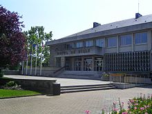
Les Pavillons-sous-Bois
| Les Pavillons-sous-Bois | ||
|---|---|---|

|
|
|
| region | Île-de-France | |
| Department | Seine-Saint-Denis | |
| Arrondissement | Le Raincy | |
| Canton | Bondy | |
| Community association |
Métropole du Grand Paris and Grand Paris Grand Est |
|
| Coordinates | 48 ° 54 ' N , 2 ° 31' E | |
| height | 50-64 m | |
| surface | 2.92 km 2 | |
| Residents | 23,962 (January 1, 2017) | |
| Population density | 8,206 inhabitants / km 2 | |
| Post Code | 93320 | |
| INSEE code | 93057 | |
| Website | http://www.les-pavillons-sous-bois.fr/ | |
 The Canal de l'Ourcq in Pavillons-sous-Bois |
||
Les Pavillons-sous-Bois is a French commune with 23,962 inhabitants (at January 1, 2017) in the Region Ile-de-France in Seine-Saint-Denis . The inhabitants are called Pavillonnais .
geography
Les Pavillons-sous-Bois is ten kilometers east of Paris. The city is located on the Canal de l'Ourcq and on the RN 3 .
Districts
- La Basoche (in the city center)
- Les Coquetiers (in the south)
- La Fourche (to the west)
Adjacent communities
- in the north of Aulnay-sous-Bois
- to the east Livry-Gargan
- to the south Le Raincy and Villemomble
- to the west Bondy
history
The city was officially founded on January 3, 1905.
politics
Town twinning
Sister cities of Les Pavillons-sous-Bois are:
- Brackley ( England ) since 1972
- Bragança ( Portugal ) since 1996
- Eichenau ( Germany ) since 2004
- Ecija ( Spain ) since 1996
- Münstermaifeld ( Germany ) since 2018
Architectural monuments
See: List of Monuments historiques in Les Pavillons-sous-Bois
literature
- Le Patrimoine des Communes de la Seine-Saint-Denis. Flohic Éditions, 2nd edition, Paris 2002, ISBN 2-84234-133-3 , pp. 265-271.
Web links
Commons : Les Pavillons-sous-Bois - Collection of images, videos and audio files

