
Bragança (Portugal)
| Bragança | ||||||
|---|---|---|---|---|---|---|
|
||||||
| Basic data | ||||||
| Region : | Norte | |||||
| Sub-region : | Terras de Trás-os-Montes | |||||
| District : | Bragança | |||||
| Concelho : | Bragança | |||||
| Coordinates : | 41 ° 48 ′ N , 6 ° 46 ′ W | |||||
| Residents: | 35,341 (as of June 30, 2011) | |||||
| Surface: | 1 173.56 km² (as of January 1, 2010) | |||||
| Population density : | 30 inhabitants per km² | |||||
| Bragança County | ||||||
|
||||||
| Residents: | 35,341 (as of June 30, 2011) | |||||
| Surface: | 1 173.56 km² (as of January 1, 2010) | |||||
| Population density : | 30 inhabitants per km² | |||||
| Number of municipalities : | 39 | |||||
| administration | ||||||
| Administration address: | Câmara Municipal de Bragança Forte S. João de Deus 5301-902 Bragança |
|||||
| President of the Câmara Municipal: | Hernâni Dinis Dias Venancio | |||||
| Website: | www.cm-braganca.pt | |||||


Bragança [ bɾɐˈɡɐ̃sɐ ] is a city ( Cidade ) and a district ( concelho ) in Portugal with 35,341 inhabitants (as of June 30, 2011). It is the capital of the Bragança district . The Braganza family is a noble family from here and was the kings of Portugal from 1640 to 1853 and the emperors of Brazil from 1822 to 1889 .
Bragança is the seat of the Roman Catholic diocese Bragança-Miranda . Episcopal Church is the new cathedral Nossa Senhora Rainha .

history
Until the independence of Portugal (1139)

Finds and excavations prove a settlement since the late Paleolithic . Around 700 to 1000 BC since the end of the Bronze Age . BC more people settled here. The Castro culture of the Asturian-Celtic Zoelae and Baniense Etnien living here lasted roughly until the appearance of the Romans from around the 2nd century BC. BC, whose influence was only slowly but steadily noticeable. Roman-Lusitan tombs, ceramics and partly bronze coins from the period were found everywhere in today's district, especially in Castro de Avelãs , which was probably the most important settlement on the Roman road to Astorga that passed here. The atlas of Justus Perthes shows only three known places in this area, namely Aquae Flaviae (today Chaves ), Veniatia (today Vinhais ), and Zoelae (today Castro de Avelãs), the capital of the Celtic tribe of the same name. The region belonged to the province of Gallaecia and was under the administration in Asturica Augusta (today Astorga). Brigantia is considered to be a place that existed at that time, from which today's Bragança can be derived directly , but there is little information about it.
The Romans were followed by the Visigoths and Suebi , who joined this region to their empire and introduced wheat cultivation, one of the few legacies of the Visigoths and Suebi, along with some local place names such as Guadramil, Gimonde or Samil. The first documented mention of the settlement ( Pagus ) from which today's Bragança developed was found in the acts of the Council of Lugo in AD 569 under the place name Vergancia . Under the administration of King Wamba , the place was recorded as Bregancia in 666 . However, since the documents do not exist in the original, but only as later copies, in which the writers' own interpretations are not excluded, these data are not considered to be unreservedly secured.
From 711 the Visigoths and Suebi were driven out by the Moors , who also left hardly any traces, at least in the areas above the Douro , in contrast to their diverse heritage in their more southern domains. Only in traditional legends and in place names such as Alfaião, Babe, Baçal, Bagueixe or Mogadouro is there a bit of this Arab heritage. Presumably the area was sparsely populated when the Reconquista came up and pushed the Moors south. The settlement that began after that was therefore under the influence of Asturias (later León), which is still evident today in the Asturleonesian languages , which have two surviving variants here with the Mirandés and the Guadramilés . In a document from King Ramiro III. of León (term of office 966-984) Bragança is then officially mentioned as a parish of the Astorga diocese.
From 1139 until today
.jpg)
Due to its elevated location on strategic traffic routes, Bragança became increasingly important, especially after the uncertain independence of the Kingdom of Portugal from 1139. King D.Sancho I rebuilt the site, which had been badly damaged in the Reconquista, re-fortified it and granted it city rights in 1187 ( Foral ). In 1199 D.Sancho I freed the city from the siege by Alfonso IX. (León) and established today's Portuguese place name. King D.Afonso III. confirmed the city rights in 1253 and also gave Bragança market rights in 1272. The place flourished as a result.
In the course of the revolution of 1383 and the attempt of the heir Castile to conquer Portugal, Bragança fell to its neighbors. It has been Portuguese again since 1401. In 1464 the previous Vila (small town) Cidade (town) was raised. King Manuel I renewed the city rights with a new Foral in 1514. In 1770 Bragança also became a bishopric.
Culture and sights
Bragança has a medieval walled urban area, the Upper Town, which is also called Cidadela . The symbol of parish sovereignty is the Pelourinho (English: "stake"), a column crowned by a capital. It stands here in the specially pierced “ Porca da Vila ”, the sculpture of a pig , which represents a relic from the Celtic period that was widespread in northern Portugal and the neighboring regions of Spain . Behind it is the 33 meter high castle tower, in which a small military museum is set up. The two well-preserved wall rings of the castle complex come from the original construction phase (1187–1189) and the second phase (14th century). The Domus Municipalis was a meeting house on whose long stone benches the city's estates met or discussed with the king. It is considered the oldest and best preserved secular building in the country.
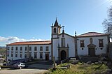
In the lower town, the old cathedral Sé Velha from the 16th century is particularly noteworthy, with gilded wood carvings ( Talha dourada ), the cloister, and the sacristy with 39 images from the life of Ignatius of Loyola . The local museum Museu Abade de Baçal is located in the former bishop's palace . a. extensive archaeological collections of the region can be seen.
The Museu Ibérico da Máscara e do Traje displays masks and costumes from the region, including related traditions on the Spanish side. The art museum Centro de Arte Contemporânea Graça Morais is dedicated to modern art.
Numerous town houses, historical public buildings, bridges, parks, sacred buildings and fountains are under monument protection. The former train station ( Estação Ferroviária de Bragança ) from the late 19th century is one of them. It is part of the city's central bus station and is partly a transport museum.

The old Sé Velha Cathedral of Bragança
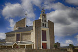
The new cathedral of Bragança
The Convento de São Francisco Monastery

The Municipal Theater ( Teatro Municipal )

.jpg)


traffic
Railways and long-distance buses
The city was the terminus of the Linha do Tua railway line until the section from Mirandela to Bragança was discontinued in 1991. The station was converted into a small railway museum, and the bus station nearby expanded. Various regional bus lines now operate here, especially to Porto there are regular bus connections. Bragança is integrated into the national bus network of Rede Expressos .
Trunk roads
Up until 2013, the north-easternmost city in the country was, alongside Portalegre and Beja, one of the three district capitals without a motorway connection, but the IP4 (part of European route 82 ) had already been expanded to include multiple lanes. Bragança is now connected to the Porto metropolitan area by the A4 motorway (toll) . From Bragança to the Spanish border at Quintanilha , the A4 is free of charge; it then turns into the well-developed country road to Zamora . Apart from this motorway, the highways are mostly in good condition, but because of the mountainous terrain they are extremely winding, making them time-consuming to use.
Airport
With Bragança Airport, which is about ten kilometers to the north, the city administration maintains a regional airport that AeroVip connects with Vila Real, Viseu, Cascais and Portimao on working days .
Local public transport
The municipal transport companies ( STUB - Serviços de Transportes Urbanos de Bragança ) cover the city area with four color-coded bus lines every half hour, the Linhas Urbanas (German: urban lines), with the yellow, green, red and blue lines. A special feature is the Linha Azul (German: Blue Line), which travels a route through the town center every 15 minutes with electric buses without fixed stops and stops on demand. The line runs from 8:00 a.m. to 7:00 p.m., and every STUB ticket entitles you to travel.
In addition, the STUB maintain twelve Linhas Rurais (German: rural lines), which drive the municipalities of the place every hour and connect them with Bragança.
Town twinning
There is a city partnership with the following cities :
-
 Spain : Zamora (since 1984)
 -
 France : Les Pavillons-sous-Bois (since 1996)
 -
 Italy : Gallicano (Tuscany) (since 1997)
 -
Spain : La Bañeza , Province of León (since 2001)
-
 Brazil : Bragança Paulista (since 2004)
 -
Spain : León (since 2006)
-
 São Tomé and Príncipe : Água Grande (since 2008)
sons and daughters of the town
- Francisco de Morais (1500–1572), writer and royal treasurer
- Jacob de Castro Sarmento (1691–1762), Jewish-Portuguese physician and scientist, pioneer of the teachings of Isaac Newton in Portugal
- Francisco Xavier Doutel (18th century), merchant, military and colonial administrator
- Álvaro Eugénio Neves de Fontoura (1891–1975), military, politician and colonial administrator
- Telmo Pires (* 1972), Portuguese-German jazz and fado singer
- Pizzi (* 1989), soccer player
Bragança County
circle
Bragança is also the seat of a district of the same name. Neighboring clockwise, starting in the north: Spain , the districts of Vimioso , Macedo de Cavaleiros and Vinhais .
With the regional reform in September 2013 , several municipalities were merged into new municipalities, so that the number of municipalities decreased from 49 to 39.
The following municipalities ( Freguesias ) are located in Bragança County:

| local community | Population (2011) |
Area km² |
Density of population / km² |
LAU code |
|---|---|---|---|---|
| Alfaião | 173 | 17.58 | 10 | 040201 |
| Aveleda e Rio de Onor | 272 | 106.35 | 3 | 040250 |
| Babe | 238 | 25.62 | 9 | 040203 |
| Baçal | 484 | 28.37 | 17th | 040204 |
| Carragosa | 190 | 27.77 | 7th | 040206 |
| Castrelos e Carrazedo | 241 | 50.53 | 5 | 040251 |
| Castro de Avelas | 460 | 13.48 | 34 | 040209 |
| Coelhoso | 319 | 19.78 | 16 | 040210 |
| Donai | 446 | 15.07 | 30th | 040212 |
| Espinhosela | 244 | 37.03 | 7th | 040213 |
| França | 238 | 53.71 | 4th | 040215 |
| Gimonde | 341 | 16.50 | 21st | 040216 |
| End of the gondola | 194 | 12.94 | 15th | 040217 |
| Gostei | 425 | 19.49 | 22nd | 040218 |
| Grijó de Parada | 296 | 31.19 | 9 | 040219 |
| Izeda, Calvelhe e Paradinha Nova | 1,212 | 72.67 | 17th | 040252 |
| Macedo do Mato | 208 | 15.54 | 13 | 040221 |
| Mós | 178 | 11.62 | 15th | 040224 |
| Nogueira | 495 | 12.07 | 41 | 040225 |
| Outeiro | 301 | 40.93 | 7th | 040226 |
| Parada e Failde | 657 | 52.13 | 13 | 040253 |
| Parâmio | 214 | 22.57 | 9 | 040229 |
| Pinela | 219 | 22.65 | 10 | 040230 |
| Quintanilha | 216 | 20.30 | 11 | 040232 |
| Quintela de Lampaças | 215 | 19.98 | 11 | 040233 |
| Rabal | 171 | 23.37 | 7th | 040234 |
| Rebordaínhos e Pombaren | 187 | 24.07 | 8th | 040254 |
| Rebordãos | 546 | 26.29 | 21st | 040236 |
| Rio Frio e Milhão | 364 | 63.51 | 6th | 040255 |
| Salsas | 389 | 26.12 | 15th | 040239 |
| Samil | 1,246 | 10.25 | 122 | 040240 |
| Santa Comba de Rossas | 304 | 8.75 | 35 | 040241 |
| São Julião de Palácios e Deilão | 400 | 80.62 | 5 | 040256 |
| Sao Pedro de Sarracenos | 366 | 15.91 | 23 | 040244 |
| Sendas | 183 | 19.17 | 10 | 040246 |
| Sé, Santa Maria e Meixedo | 22,016 | 35.69 | 617 | 040257 |
| Serapicos | 208 | 28.25 | 7th | 040247 |
| Sortes | 296 | 21.30 | 14th | 040248 |
| Zoio | 189 | 24.39 | 8th | 040249 |
| Bragança County | 35,341 | 1,173.56 | 30th | 0402 |
The Freguesia Sé, Santa Maria e Meixedo represents the actual municipality.

Population development
| Population in Bragança County (1801–2011) | |||||||||
|---|---|---|---|---|---|---|---|---|---|
| 1801 | 1849 | 1900 | 1930 | 1960 | 1981 | 1991 | 2001 | 2011 | |
| 27,961 | 16,929 | 30,513 | 29,750 | 37,553 | 35,380 | 33,055 | 34,750 | 35,319 | |
Municipal holiday
- August 22nd
literature
- Thomas G. Schattner (Ed.): Archaeological guide through Portugal (= cultural history of the ancient world . Vol. 74). Philipp von Zabern, Mainz 1998, ISBN 3-8053-2313-1 p. 78
Web links
- City website , Portuguese, accessed May 3, 2010
- Photos of Bragança , accessed May 3, 2010
Individual evidence
- ↑ a b www.ine.pt - indicator resident population by place of residence and sex; Decennial in the database of the Instituto Nacional de Estatística
- ↑ a b Overview of code assignments from Freguesias on epp.eurostat.ec.europa.eu
- ^ Mensagem do Presidente. Retrieved December 7, 2015 .
- ^ Breve Panorâmica Histórica. In: cm-braganca.pt. Retrieved December 7, 2015 (Portuguese).
- ↑ www.verportugal.net , accessed on February 12, 2013
- ^ Lydia Hohenberger, Jürgen Strohmaier: Portugal. 2nd edition, DuMont Reiseverlag, Ostfildern 2009, p. 308 f.
- ↑ www.monumentos.pt , accessed on February 12, 2013
- ↑ www.aerovip.pt , accessed December 7, 2015
- ↑ Municipios Portugueses, Geminações de Cidades e Vilas
- ↑ www.anmp.pt , accessed on February 11, 2013
- ^ Publication of the administrative reorganization in the Diário da República gazette of January 28, 2013, accessed on March 16, 2014
