Macedo de Cavaleiros
| Macedo de Cavaleiros | ||||||
|---|---|---|---|---|---|---|
|
||||||
| Basic data | ||||||
| Region : | Norte | |||||
| Sub-region : | Terras de Trás-os-Montes | |||||
| District : | Bragança | |||||
| Concelho : | Macedo de Cavaleiros | |||||
| Coordinates : | 41 ° 32 ′ N , 6 ° 58 ′ W | |||||
| Residents: | 6257 (as of June 30, 2011) | |||||
| Surface: | 14.91 km² (as of January 1, 2010) | |||||
| Population density : | 420 inhabitants per km² | |||||
| Postal code : | 5340 | |||||
| politics | ||||||
| Address of the municipal administration: | Junta de Freguesia de Macedo de Cavaleiros Bairro Padres Marianos Zona Industrial 5340-296 Macedo de Cavaleiros |
|||||
| Macedo de Cavaleiros county | ||||||
|
||||||
| Residents: | 15,776 (as of June 30, 2011) | |||||
| Surface: | 699.14 km² (as of January 1, 2010) | |||||
| Population density : | 23 inhabitants per km² | |||||
| Number of municipalities : | 30th | |||||
| administration | ||||||
| Administration address: | Câmara Municipal de Macedo de Cavaleiros Jardim 1º de Maio 5340-218 Macedo de Cavaleiros |
|||||
| President of the Câmara Municipal: | Beraldino José Vilarinho Pinto ( PSD ) | |||||
| Website: | www.cm-macedodecavaleiros.pt | |||||
Macedo de Cavaleiros is a city ( Cidade ) and a district ( concelho ) in Portugal with 6257 inhabitants (as of June 30, 2011).
history
The place was officially mentioned for the first time in 1258 as an insignificant settlement called Vilar de Masaedo . In 1320 it was already listed as Macedo de Cavaleiros , still as a small town. In the course of the administrative reforms in 1853 , surrounding districts were dissolved and the district of Macedo de Cavaleiros was re-created. In 1863 the place was raised to a small town ( Vila ), and in 1999 it was named a city ( Cidade ).
administration
circle


In the course of the regional reform of September 29, 2013 , a number of municipalities were merged, so that the Macedo de Cavaleiros district has now consisted of 30 municipalities (previously 38). The following municipalities ( Freguesias ) are in the Macedo de Cavaleiros district (in brackets the previous municipalities that were dissolved in 2013):
| local community | Population (2011) |
Area km² |
Density of population / km² |
LAU code |
|---|---|---|---|---|
| Ala e Vilarinho do Monte | 484 | 40.77 | 12 | 040539 |
| Amendoeira | 427 | 15.72 | 27 | 040502 |
| Arcas | 262 | 23.02 | 11 | 040503 |
| Bornes e Burga | 443 | 26.05 | 17th | 040540 |
| Carrapatas | 197 | 6.51 | 30th | 040507 |
| Castelãos e Vilar do Monte | 547 | 18.84 | 29 | 040541 |
| Chacim | 265 | 19.43 | 14th | 040509 |
| Cortiços | 296 | 24.25 | 12 | 040510 |
| Corujas | 168 | 9.91 | 17th | 040511 |
| Espadanedo, Edroso, Murçós e Soutelo Mourisco | 448 | 64.13 | 7th | 040542 |
| Ferreira | 194 | 19.64 | 10 | 040514 |
| Grijó | 371 | 8.91 | 42 | 040515 |
| Lagoa | 312 | 35.11 | 9 | 040516 |
| Lamalonga | 402 | 16.97 | 24 | 040517 |
| Llamas | 278 | 7.79 | 36 | 040518 |
| Lombo | 346 | 14.40 | 24 | 040519 |
| Macedo de Cavaleiros | 6,257 | 14.91 | 420 | 040520 |
| Morais | 644 | 52.16 | 12 | 040521 |
| Olmos | 208 | 18.70 | 11 | 040523 |
| Peredo | 258 | 22.08 | 12 | 040524 |
| Podence e Santa Combinha | 306 | 19.45 | 16 | 040543 |
| Salselas | 386 | 36.31 | 11 | 040526 |
| Sezulfe | 263 | 15.22 | 17th | 040528 |
| Talhas | 316 | 43.80 | 7th | 040530 |
| Talhinhas e Bagueixe | 329 | 35.25 | 9 | 040544 |
| Vale Benfeito | 181 | 15.14 | 12 | 040532 |
| Vale da Porca | 286 | 17.43 | 16 | 040533 |
| Vale de Prados | 431 | 10.37 | 42 | 040534 |
| Vilarinho de Agrochão | 235 | 13.85 | 17th | 040536 |
| Vinhas | 236 | 33.02 | 7th | 040538 |
| Macedo de Cavaleiros county | 15,776 | 699.14 | 23 | 0405 |
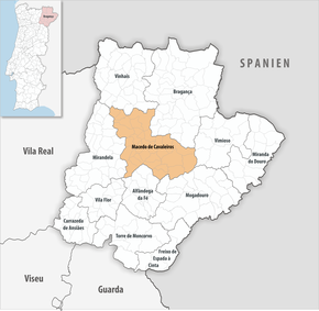
Macedo de Cavaleiros is the seat of a district of the same name. The neighboring areas are (starting clockwise in the north): Vinhais , Bragança , Vimioso , Mogadouro , Alfândega da Fé and Mirandela :
| North: Vinhais | Northeast: Bragança | |
| West: Mirandela | Macedo de Cavaleiros | East: Vimioso |
| South: Alfândega da Fé |
Population development
| Population in the district of Macedo de Cavaleiros (1864–2011) | ||||||||
|---|---|---|---|---|---|---|---|---|
| 1864 | 1900 | 1930 | 1960 | 1981 | 1991 | 2001 | 2011 | |
| 19 200 | 19 781 | 26 199 | 21 608 | 18 930 | 17 449 | 17 210 | 15 776 | |
Town twinning
sons and daughters of the town
- Nicolau Pereira de Campos Vergueiro (1778–1859), coffee planter, liberal politician, minister in the Brazilian Empire
- Jaime Alberto de Castro Morais (1882–1973), officer, member of the opposition since 1926
- Raul Rêgo (1913–2002), journalist, Freemason, politician, minister after the Carnation Revolution
- João de Deus (1928–2019), clergyman in East Timor
- Adriano Moreira (* 1922), lawyer and conservative politician
- António Manuel Pires Cabral (* 1941), writer
- Roberto Leal (* 1951), Brazilian-Portuguese entertainment singer
- Zé Cabra (* 1965), comic singer and painter
- Tiago Carlos Morais Valente (* 1985), football player
Web links
- Map of the Freguesia Macedo de Cavaleiros at the Instituto Geográfico do Exército
- Official website
Individual evidence
- ↑ www.ine.pt - indicator resident population by place of residence and sex; Decennial in the database of the Instituto Nacional de Estatística
- ↑ a b Overview of code assignments from Freguesias on epp.eurostat.ec.europa.eu
- ↑ http://codigopostal.ciberforma.pt/dir/empresa2.asp?emp=3489
- ↑ www.ine.pt - indicator resident population by place of residence and sex; Decennial in the database of the Instituto Nacional de Estatística
- ↑ www.monumentos.pt (under Cronologia ), accessed on February 10, 2013
- ↑ www.anmp.pt , accessed on February 10, 2013


