
Sevran
| Sevran | ||
|---|---|---|

|
|
|
| region | Île-de-France | |
| Department | Seine-Saint-Denis | |
| Arrondissement | Le Raincy | |
| Canton | Sevran | |
| Community association |
Métropole du Grand Paris and Paris Terres d'Envol |
|
| Coordinates | 48 ° 56 ' N , 2 ° 31' E | |
| height | 46-66 m | |
| surface | 7.28 km 2 | |
| Residents | 51,016 (January 1, 2017) | |
| Population density | 7,008 inhabitants / km 2 | |
| Post Code | 93270 | |
| INSEE code | 93071 | |
| Website | http://www.ville-sevran.fr/ | |
 Town Hall ( Hôtel de ville ) |
||

Sevran is a commune with 51,016 inhabitants (at January 1, 2017) in the Seine-Saint-Denis in the region of Ile-de-France . The inhabitants are called Sevranais .
geography
Sevran is located about 18 kilometers northeast of Paris in a very urbanized area of the Île de France. The municipal area of 7.28 km² is practically completely built over. The Canal de l'Ourcq (German: Ourcq Canal) and the Morée stream flow through the Sevran area. Neighboring municipalities are Villepinte in the north, Aulnay-sous-Bois in the west, Vaujours in the east and Livry-Gargan in the south. The settlement areas are mostly contiguous.
Population development
| year | 1962 | 1968 | 1975 | 1982 | 1990 | 1999 | 2006 | 2017 |
| Residents | 17,969 | 20,253 | 34,221 | 41,809 | 48,478 | 47,063 | 51.106 | 51,016 |
| Sources: Cassini and INSEE | ||||||||
With 51,016 inhabitants (as of January 1, 2017) Servan is one of the larger agglomeration communities in the Seine-Saint-Denis department. In 1962 the community still had 17,969 inhabitants. A marked growth in population was recorded especially in the 1970s and 1980s.
Servan is in the outskirts of Paris , typical for this is the high population density of around 7,000 inhabitants per km² and the above-average proportion of foreigners.
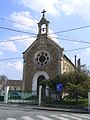
Sainte-Elisabeth church

Saint Martin Church


literature
- Le Patrimoine des Communes de la Seine-Saint-Denis. Flohic Éditions, 2nd edition, Paris 2002, ISBN 2-84234-133-3 , pp. 361–367.
Web links
Individual evidence