
Le Raincy
| Le Raincy | ||
|---|---|---|
.svg)
|
|
|
| region | Île-de-France | |
| Department | Seine-Saint-Denis | |
| Arrondissement | Le Raincy | |
| Canton | Villemomble | |
| Community association |
Métropole du Grand Paris and Grand Paris Grand Est |
|
| Coordinates | 48 ° 54 ' N , 2 ° 31' E | |
| height | 56-114 m | |
| surface | 2.24 km 2 | |
| Residents | 14,648 (January 1, 2017) | |
| Population density | 6,539 inhabitants / km 2 | |
| Post Code | 93340 | |
| INSEE code | 93062 | |
| Website | http://www.leraincy.com/ | |
 town hall |
||

Le Raincy is a French municipality with 14,648 inhabitants (at January 1, 2017) in the Seine-Saint-Denis in the region of Ile-de-France . It is the administrative center of the Arrondissement of Le Raincy and the canton of Villemomble . The inhabitants are called Raincéens .
Neighboring communities
- to the northwest: Livry-Gargan
- to the northeast: Clichy-sous-Bois
- to the southeast: Gagny
- to the south: Villemomble
- to the west: Les Pavillons-sous-Bois
Traffic routes
- Autoroute A3 (Gagny / Villemomble / Le Raincy)
- RER : Le Raincy – Villemomble – Montfermeil
history
Le Raincy is located in the center of the Pays d'Aulnoye . The place was formerly called Les Rincis, which means quarry; this quarry was in the Forêt de Bondy and was owned by the Abbey of Tyron ( Diocese of Chartres ) since 1130 .
In 1639 the area was bought by Jacquer Bordier , who had a castle built here by Louis Le Vau in 1640 . He connected Raincy to Bondy , who also belonged to him.
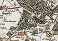
Le Raincy around 1780 (Cassini)

Le Raincy Castle

Le Raincy Castle


Population development
- 1962: 14.908
- 1968: 14.224
- 1975: 13,767
- 1982: 13.187
- 1990: 13,478
- 1999: 12,961
- 2006: 14,130
Attractions
- The Notre-Dame du Raincy church by Auguste Perret is a reinforced concrete and glass construction from 1923 with one of the largest glass window cycles of the 20th century based on designs by Maurice Denis and Alain-Marie Couturier. The building was declared a monument historique in 1966.
- The synagogue was built in 1930/31.
See also: List of Monuments historiques in Le Raincy
Town twinning
Personalities
- Alexandre Chatrian (1870–1890), writer and mayor
- André-Max Leroy (1892–1978), livestock scientist and first president of the European Association for Animal Production.
- Maurice Cottenet (1895–1972), French national football player
- Jacques Tréfouël (1897–1977), chemist
- Éric Raoult (* 1955), politician ( UMP ) and mayor of Le Raincy
- Philippe Vernet (* 1961), track cyclist
- Sébastien Dumez (* 1974), racing car driver
- Sefyu (* 1981), French rapper
literature
- Le Patrimoine des Communes de la Seine-Saint-Denis. Flohic Éditions, 2nd edition, Paris 2002, ISBN 2-84234-133-3 , pp. 287-295.