
Lower Moselle


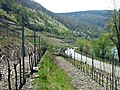
With Untermosel or Terrassenmosel of almost 100 will flow kilometers long lower valley portion of the Mosel between Pünderich and their confluence with the Rhine in Koblenz designated. The Lower Moselle landscape differs from the Middle and Upper Moselle in that it is mostly narrower valley with partly high and steep flanks . In the slopes facing south and west, viticulture is often carried out in very small , terraced steep slopes .
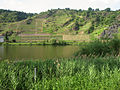
The expansion of the Moselle into a major shipping route in the 1960s changed the shape of the river and the banks permanently. Five barrages between Koblenz and Zell for the locks of large ships turned a sometimes narrow, sometimes wide river bed with gently sloping banks into a canal-like body of water, which is contained in the storage areas by wall walls and rock fillings.
Geography and boundaries
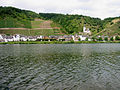
The Terrassenmosel begins in the wine town of Pünderich and flows into the Rhine in the city of Koblenz at the Deutsches Eck . It separates the Eifel and Hunsrück low mountain ranges and flows through the two districts of Cochem-Zell and Mayen-Koblenz in northern Rhineland-Palatinate . Most of the settlements in the valley are smaller and have been expanding in area since the end of the 20th century. Cities with a central function are Zell (2009 = 4200 inh.) And Cochem (2009 = 4900 in.) Tourism and viticulture are important economic factors in this landscape.
A first separation of the Lower and Middle / Upper Moselle was possibly the result of the Roman provinces of Germania superior (Upper Germany) and Gallia Belgica founded in the 1st century AD . The border between the two administrations crossed the river between the current Moselle towns of Traben-Trarbach and Zell . In the late Middle Ages, the Upper and Lower Archbishopric of the Electorate of Trier separated here . From 1798 to 1814 this was the border between the French departments of Saar and Rhine and Moselle , and from 1824 to 1999 between the administrative districts of Koblenz and Trier . This is also where the geographic circle of the earth runs at 50 ° north latitude, which in the past was often viewed as a critical boundary for viticulture in northern landscapes. Biologists see the Mediterranean fauna on the southern slopes of the Moselle valley, which are favored by small climates, as the markings of the northern border of the Mediterranean. The regional wine-growing authority calls the Terrassenmosel the "Burg Cochem wine-growing area".

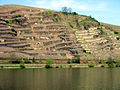
3. Old terraces under a medieval castle: Metternich ruins with the steep slope of the Beilsteiner Schlossberg
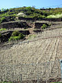
4. Traditional piling on the lower slope. Decay in the upper terraces. Karden Dechantsberg

5. New systems with trellis wire frames after clearing old terraces in Hatzenporter Kirchberg

6. Terrace stairs in the old part of the Alkener Burgberg

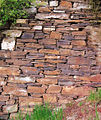
7. Old, rounded dry stone wall on a rock foundation: Koberner Schlossberg below the late Romanesque Matthias Chapel


Geology and history


The valley slopes of the Lower Moselle show, with strikingly different types of rock and rock formations, the end of a geological development of the Moselle region that began around 390 million years ago in the Lower Devonian . At that time there was a shallow sea in this area, which was bordered in the north of the Old Red continent and in the south by island structures of the Central German Threshold . For millions of years, sediments from these land masses were washed into the slowly sinking shallow sea. This created a mighty store of rock packages with a thickness of up to 14 kilometers, which geologists call the "Moselle trough". As a result, the deposits solidified through folding, pressure and heat to form rock masses of varying stability (foliation occurs at 250 ° –400 ° C, silica, i.e. quartz, can be mobilized from 300 ° C). Most of this development took place in the Carboniferous Age 350 million years ago, when the Rhenish Slate Mountains were lifted and unfolded.
The formation of today's Moselle landscape began in the Tertiary . The waters of the later Moselle first washed a flat, wide valley into a relatively flat hilly landscape. In the last 500,000 years the uplift of the Rhenish Slate Mountains increased, so that the Moselle cut deep into the rock masses.
Until the middle of the 20th century, the settlement of this cultural landscape, of densely built-up, small towns, surrounded by orchards, gardens and terraced vineyards, only changed at long intervals. Today, many former fruit-growing areas are now fallow or have given way to local expansions, commercial areas and traffic routes, but also large-scale land-cleared vineyards. Many old terrace walls were demolished and leveled on the slopes to simplify management and the construction of farm roads. The impression of a historically grown terraced cultural landscape is therefore only partially applicable to some valley passages. With the help of mainly publicly funded job creation measures, overgrown, overgrown terraces are "cleared" in order to preserve the image of a man-made cultural landscape and the biotopes of heavily sunlit terraces in some locations. The cutting and removal of vines from abandoned sites is mandatory to prevent plant diseases such as black rot or phylloxera .
Vineyards that have fallen fallow are also the result of a structural change in viticulture, in which small businesses that mainly only sell barrel wine give up cultivation for economic reasons or due to a lack of succession or concentrate on viticulture in less steep, only slightly sloping and land-adjusted locations.
From 1999 to 2009, the steep slope viticulture decreased from 998 ha to 764 ha (Statistisches Landesamt Rheinland-Pfalz). In the opposite direction, however, there are recultivations of old locations, which were already assessed and mapped accordingly in the Napoleonic and Royal Prussian times due to above-average land prices. Many of these plants stand out due to their different tillering and larger row widths: Instead of the narrow single vines with traditional arching, new vine plants are increasingly on trellis wire frames and at greater distances from one another. In the Moselweisser Hamm , shortly before Koblenz, old vineyards were recultivated instead of walls with sloping, green earth embankments (Fig. 11).
Places with extensive viticulture are in the district of Cochem-Zell : Pünderich , Briedel , Kaimt , Merl , St. Aldegund , Neef , Bremm , Eller , Ediger , Senheim , Bruttig-Fankel , Ellenz-Poltersdorf , Ernst , Valwig , Klotten , Pommern , Treis -Karden , Müden and Moselkern .
In the Mayen-Koblenz district : Hatzenport , Alken , Lehmen , Niederfell , Kobern-Gondorf and Winningen . Lay , Moselweiss and Güls are in the city of Koblenz.
The geographical name Untermosel includes the tourist area names Zeller Land (area of the Verbandsgemeinde Zell between Pünderich and Neef including the places on the Hunsrück ) and Ferienland Cochem (area of the Verbandsgemeinde Cochem ) between Bremm and Klotten .
The Calmont von Bremm and Ediger-Eller (steepest vineyards in Europe), the Ediger Elzhofberg , the Valwiger Herrenberg and the Kobern-Winninger Uhlen u. a. are among the steepest terraces on the Moselle. The Association of German Predicate and Quality Wineries (VDP) has been defining parcels in the Marienburg and Nonnenberg from Pünderich, Kirchberg and Stolzenberg from Hatzenport and Uhlen and Röttgen from Winningen since 2003 , also following the location evaluations of the wine-growing map for the Koblenz administrative region from 1897 classified as "first class" locations. However, the classification was only made for the sites that members of the Vdp cultivate. Other locations were not taken into account in the Vdp.
The preferred grape variety on the Terrassenmosel is Riesling with 59.7% (Statistisches Landesamt Rheinland-Pfalz 2005) . The Pinot Blanc with 2.6% and the Pinot Noir with 5.5% follow at a distance, but with an upward trend.
For the landscape with the terraced vineyards in extremely steep slopes on the Moselle slopes, the term Terrassenmosel , which was specially intended for viticulture and tourism, has been established since the end of the 20th century . It was introduced by the Winningen winemaker Reinhard Löwenstein. This designation propagates a unique position also compared to other regions due to the landscape characteristics with the steep slope viticulture based on it. B. the adjacent Middle Moselle. Tourism and wine marketing in particular now use the Terrace Moselle instead of the Lower Moselle to indicate their own identity and origin.
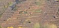
10. Cultivated terraces next to fallow ones in particularly steep and small parceled areas: Hatzenporter Stolzenberg
11. New terraces and transversely running tillers on trellis wire frames: Moselweisser Hamm

12. New forest coverings in the old steep slope: Valwiger Herrenberg

13. Without the "Monorackbahn" the old steep slope would not have been recultivated: Ediger Elzhofberg
13a. Several monorack tracks on steep slopes near Ediger-Eller .

14. In decline from the middle of the 20th century: Gondorfer Fuchshöhle in a Moselle side valley near Kobern-Gondorf.


Development of the terrace construction on the Lower Moselle

At the end of the 1970s, archaeologists found the first evidence of possible Roman terracing on the slopes of the Moselle valley: land consolidations and the creation of new farm roads in vineyards on the Middle Moselle and the Upper Lower Moselle exposed the foundations of ancient wine press houses at the foot of slopes. The sites in steep slopes that are still cultivated today can be seen as evidence of Roman terracing of the valley slopes in the 3rd century AD.
Similar finds have not yet been made between Cochem and Koblenz. Reasons for this - despite many Gallo-Roman evidence of settlement - may have been a presumably lower population, but also the railway and road construction at the end of the 19th century, for which many vineyards at the foot of well-known steep slopes in z. B. Hatzenport, Karden, Kobern or Winningen were removed; possible evidence of ancient wine presses could have been lost undetected. However, there is a written tradition for early steep-slope viticulture in a Moselle travel description by the ancient writer Venantius Fortunatus for the end of the 6th century AD : ... Where leafy vineyards rise to bare mountain heights / and rich, shady green covers the dry scree / Here the harvest of the colored grapes of the winegrowers collects / even on the cliff he reads the fruit .
The downfall of Roman civilization and the changes in population during the migration period have probably left viticulture on the Lower Mosel largely unmolested. Laws of the Franconian kings protected the long-established winegrowers. Settlement islands in which the Moselle Romansh was spoken instead of a Franconian language were preserved here until the High Middle Ages . The dialect word for a vineyard terrace Chur or Kuur (plural Chuer, Kuure), borrowed from Cura (Latin for care) or Chorus (Latin for the raised (altar) room in a church) probably originates from this time .
From the 9th century onwards, there is a wealth of documents relating to viticulture for almost all places in the Lower Moselle. (e.g. Ediger in 766, Kobern 817, Bruttig 898). Many vineyards were probably still flat or lower slopes. The High Middle Ages have been considered to be the epoch in which builders began to build high, stable terrace walls on steep slopes of the Moselle - derived from the skill of building technically demanding castle complexes on protruding rock ridges and over steep abysses. The terrace walls were probably mostly set dry : the large amount of mortar that was required for the irregular quarry stone work would have been simply too expensive. Archbishop Balduin spent around 30 percent of the construction costs on burning and transporting the lime required for the mortar and plaster of his castle building in the Middle Rhine-Lower Moselle region. (Fig. 16 and 17).


The population increase in the Middle Ages, the great demand from Cologne as a trading center, today's Belgium and the Netherlands and the high per capita consumption of wine compared to today may have led to the expansion of the cultivation areas and thus to further terracing. The sites that are still managed today can be found in deeds of ownership and mortgage lending from this period, which may have been terraced sites as early as the 12th century. A planting guide from the 14th century says that noble wine is pestered (steep slopes bring better wine). "Mountains" was the name for steep slopes in the valley slopes until the 19th century. Phases of standstill and abandonment of terraces followed epidemics, the chaos of war or climate depressions.
At the end of the 19th century, the terracing of valley slopes of the Lower Moselle - in some cases almost to the edge of the mountain - had probably reached its greatest extent. The gradual terracing up the slope also happened particularly in the " terroirs ", which had been known for coveted and well-paid wines from the earliest times. In order to be able to produce larger quantities, terraces were also created in the side valleys and less favored locations. Around 1880, around 2500 hectares of mostly steep vineyard areas are mentioned for the Koblenz administrative region.
From the middle of the 20th century, terraced viticulture stagnated on the steep slopes of the Lower Moselle. The systems in terraces that were difficult to access and that could only be managed by expensive manual labor became overgrown and overgrown, many walls collapsed. In the 1960 / 70s, the merging of small, graded, less steep slopes into larger agricultural areas (land consolidation) began. The management could be made easier with mechanical and thus more cost-effective labor. But it also meant the leveling of many, formerly stepped terraced slopes and the demolition of many vineyard walls that were important for the ecology and the landscape (Fig. 30–33).
Public subsidies, subsidies from national and European budget funds, and in particular the simplification of work through the installation of the “ mono-rack railways ” developed in Switzerland , which simplified the mechanical transport of people and material on the steep slopes, save some locations from deterioration today (Fig. 13 and 13a).
Forms and meaning of the vineyard terraces


The advantages of ground terracing to increase cultivation areas were already discussed in ancient textbooks on Roman agriculture (e.g. Junius Moderatus Columella around 60 AD in De re rustica ).
From the 19th century a description of the terrace construction on the Moselle has been handed down by a Baden oenologist, which was probably already valid in Roman times: Because all the slopes are rocky in nature, where there is little building ground in between, the whole thing is worked through to the specified depth. For the rocks are broken off and crushed; those pieces that do not weather and disintegrate in the air are used as bricks for the terraces (Figs. 18 and 19). So one terrace is formed around the other until the whole piece is laid out.
High terrace walls are often mortared for better stability. New masonry is now being built using stones from regional quarries to protect the landscape. The depth of the wall and the foundation are based on the planned height. Two meters of wall height - if not on natural rock - stand on very large stones or a concrete foundation 100 cm × 60 cm deep and high. An uphill inclination to stabilize the wall can be achieved by the angled construction or the stacking of stones set back from the bottom up. The stones are placed in an alternation from 2 to 1 and 1 to 2 and each have at least 3 places on their surface. Around two tons of stone material are used for one cubic meter of wall.
In addition to their agricultural importance, the terraces are of great cultural and historical value due to their form of cultivation dating back to the Middle Ages and their often masterly architecture. With their small chambered areas under cultivation, they form protective barriers against plant diseases and provide a habitat for a diverse, warmth-loving fauna and flora. The Apollo butterfly , the emerald lizard , the gold lacquer and the zippammer are just the best-known representatives of the Terrassenmosel ecosystem, in which a large number of small animals and plant species have been recorded during studies.
Terrace wall "pictures"
When walls are set with remarkable care and stability, one speaks of a “beautiful wall picture”. The laying of a vineyard wall is nowadays carried out by masons who specialize in this, especially in the larger wineries. Until the middle of the 20th century, when the Lower Mosel viticulture consisted mostly of small family businesses, every winemaker had to be able to build a wall. Especially the repair of collapsed parts of the wall was done by himself.

20. Set in a circle, for more terrace stability. Niederfeller Kahllay

21. Very old arch section in a dry stone wall. Koberner Weissenberg

22. Vertical! Stone set in the terrace of the former vineyard In der Mark . Trimbs in the Nettetal
23. Ideal image of a dry stone wall. Set with stone material broken "on site". Hatzenporter Castle Bischofsteiner

24. Stable wing wall. Lehmener Ausonius stone


See also: Obermosel , Mittelmosel
Vineyards (only the Rhein-Mosel community described here)
At the beginning of the 21st century, wine was still grown in terraces that were structured in small pieces in all 13 locations of the Lower Moselle VG , albeit on a very different scale. From 1999 to 2009 the cultivated area decreased slightly from 223 ha to 205 ha. The number of full-time farms remained almost constant: 42 to 41, the number of part-time winemakers fell sharply: from 60 to 43. (Information from the municipal administration and the State Office Rhineland-Palatinate)
In small parceled locations, the valley slopes often still show up in the traditional single-storey terraces. But also in the steep slopes of Lehmen, Kobern-Gondorf and Winningen, where particular investments have been made in the maintenance and reconstruction of the vineyard walls, new vines are being raised more and more frequently on transverse trellis wires.
There are larger, partly land-adjusted, less steep locations in the Klosterberg von Lehmen and the Domgarten von Winningen.
The German Wine Law drastically reduced the previous location names. For the area from castles to Koblenz, the following location names were listed downstream:
|
Right side of the Moselle (as of 2010)
In the city of Koblenz (right side of the Moselle):
|
Left side of the Moselle (as of 2010)
|
In the city of Koblenz (left side of the Moselle):
|
25. Winninger Erste Lage Roettgen . The light reddish colored parts of the wall are the parts of the terrace wall that have been renewed with Grauwackestones.

26. Too steep, too fragmented, too labor-intensive, abandoned: the former Red Wall in Alken's Hunnenstein

27. Newly planted after dismantling old terraces: Alkener Burgberg below Thurandt Castle

28. Small terraces in a famous location: Winninger Uhlen

29. Small terraces on the Moselle valley bridge : Winninger Hamm with a view of the village of Dieblich

30. In the Lehmener Ausoniusstein , cleared and released: Almost a towering monument to the hard work of earlier generations of winemakers.


From the old terracing and tillering to the current recultivation
The Hatzenporter Kirchberg is an example of the change in wine growing on steep slopes with old terraces (Fig. 31–34). Until the middle of the 20th century, the hillside in the local area was largely planted and cultivated by a large number of vintners. At the end of the century, the number of Hatzenporter winemakers and the plots they cultivated had decreased significantly. The amalgamation of parcels, new traffic routes through the slope and the abandonment of small terraces in higher elevations made it possible to use more economical cultivation methods.

31. In the 1950s: Planted terraces all over the steep slope. Hatzenporter Kirchberg
32. Around 1990: The Kirchberg with many fallow terraces
33. Around 1995: One new and two widened paths facilitate the traffic and use of technical equipment
34. Since 2003 the Kirchberg has been classified as a “first location”


literature
- Rheinisches Landesmuseum Trier: 2000 years of wine culture on the Mosel-Saar-Ruwer. Exhibition catalog, Trier 1987.
- Karl-Josef Gilles : Bacchus and Sucellus. Briedel 1999, ISBN 3-89801-000-7 .
- Franz Dötsch, Dieter Rogge: Vineyard walls in steep slopes - history, forms and meaning for the Lower Moselle landscape. Kobern-Gondorf 2002, ISBN 3-9806059-1-4 .
- Joachim Krieger: Terrace culture on the Lower Moselle. Neuwied 2003, ISBN 3-933104-08-4 .
- H. Cüppers, K.-H. Faas, W. Stöhr: Mosel-Saar-Ruwer. Stuttgart 1981, ISBN 3-512-00546-2 .
- Reinhard Löwenstein: From Öchsle to Terroir. In: FAZ , October 7, 2003.
- Society for the History of Wine V. Series of publications on wine history , Wiesbaden
Web links
- Information about the holiday region of Cochem
- Information about the Zeller Land
- Moselle from Zell to Koblenz - Along the lower Moselle from the TV series Bilderbuch Deutschland of ARD .
- Exact outlines of the individual layers
Individual evidence
- ^ Rheinisches Landesmuseum Trier, exhibition catalog Mosel - river, waterway and living space , Trier 1989
- ↑ Heinz Cüppers (Ed.): The Romans in Rhineland-Palatinate . Stuttgart 1990, ISBN 3-8062-0308-3
- ^ Franz-Josef Heyen (Ed.): History of the State of Rhineland-Palatinate . Freiburg / Würzburg 1981, ISBN 3-87640-054-6
- ↑ Geolog. Explanations Bernd Ternes, Service Center for Rural Area Westerwald-Osteifel, Mayen
- ^ State of Rhineland-Palatinate, service center for rural areas Moselle, terroir on the Moselle, Saar and Ruwer , Bernkastel, etc. D.
- ↑ Karl-Josef Gilles (Ed.): Recent research on Roman viticulture on the Moselle and Rhine , Society for the History of Wine Wiesbaden 1995, ISSN 0302-0967
- ↑ Hermann Ament: The Franks in the Roman cities of the Rhine zone . In: Reiss Museum Mannheim (Ed.): The Franks - Trailblazers of Europe . Mainz 1996, ISBN 3-8053-1813-8 , p. 129 ff.
- ↑ Rudolf Post, On the history and research of the Moselle Romanic , Rhine. Quarterly Sheets No. 68, Bonn 2004
- ↑ Barbara Weiter-Matysiak: Viticulture in the Middle Ages . Supplement to the history. Atlas d. Rheinlande VII / 2, Cologne 1985
- ↑ Ingeborg Scholz: Archbishop Balduin (1307-1354) as the builder of state castles in the Archbishopric of Trier . Münster / W. 2004, pp. 164–166 (cf. Diss. Uni. Marburg 2003)
- ^ Felix Meyer: Viticulture on the Moselle, Saar and Ruwer . Koblenz 1926
- ↑ Jof. Ph. Bronner: Viticulture in the province of Rheinhessen, in the Nahethal and Moselthal . Heidelberg 1834
- ↑ Annette and Bodo Müller: Model study on the importance of vineyard walls in Niederfell and Winningen for species and biotope protection . Mannheim-Ehringshausen 1985