
Moselle valley bridge (A 61)
Coordinates: 50 ° 18 ′ 53 ″ N , 7 ° 29 ′ 40 ″ E
|
|
||
|---|---|---|
 |
||
| use | Highway | |
| Convicted | Federal motorway 61 | |
| Crossing of | Moselle | |
| place | Winningen ↔ Dieblich | |
| construction | Steel girder bridge | |
| overall length | 935 m | |
| width | 30.5 m | |
| Longest span | 218.2 m | |
| Construction height | 6 to 8.5 m | |
| height | 136 m | |
| vehicles per day | 45,000 | |
| building-costs | 40 million DM | |
| start of building | 1969 | |
| completion | 1972 | |
| location | ||
|
||
| Road map of the Koblenz area | ||
 |
||

The Moselle valley bridge is the crossing of the federal highway 61 over the Moselle and at the same time connects the Hunsrück with the Eifel . The motorway bridge lies between the municipalities of Dieblich and Winningen .
Bridge building

The Moselle valley bridge was built between 1969 and 1972 on behalf of the Federal Ministry of Transport as part of the construction of the new federal motorway 61. The Rhineland-Palatinate road administration and the Andernach road construction department were involved in the construction . The company Schnorpfeil / Heinz Schnorpfeil Bau GmbH, DSD Dillinger Stahlbau, Ed. Züblin AG , Julius Berger Bauboag AG and Lenz-Bau AG. On July 1, 1971, an engineer fell to his death while surveying the Blumslay rock. At that time the bridge cost around DM 40 million .
In the initial construction phase, special problems arose with the foundation . In the Moselle valley about 22 meters thick layers of gravel and sand were found, which would have counteracted the stable statics of the bridge. Therefore, in order to hit stable rock, a deep foundation with large bored piles made of concrete with a length of up to 24 meters had to be made.
The steel superstructure of the bridge was started from Dieblich across the Moselle. Using auxiliary supports, a 12 meter long section of the hollow steel box was driven in 56 so-called shots. From Winningen, the remaining hollow box parts with 22 sections each were installed using the same construction method . The hollow box parts, prefabricated elsewhere, were attached to the construction site using cantilever arms , mounted and complemented with cover sheets.
Technical details


It is a girder of steel with foundations of five columns and two abutments of reinforced concrete , which in a combined sliding - and climbing formwork were prepared. The bridge is 935 meters long and 30.5 meters wide. The maximum height of the roadway above the ground is 136 meters.
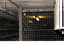
The spans between the individual pillars that can be accessed using ladders and platforms are 156.8 m - 218.2 m - 170.5 m - 146.1 m - 133.9 m - 109.6 m. The single-cell steel superstructure, which is 6 to 8.5 meters high and 10.8 meters wide at the bottom, runs over the pillars, which were built with a hollow cross-section made of reinforced concrete and a wall thickness of 0.3 m. From this steel superstructure, a ladder is used to exit onto the pillar platforms. From there it is possible to enter the interior of the pillars. The entire steel structure weighs approximately 11,463 tons.
The structural system of the structure is a continuous girder with seven supports, the fixed point being on the Winningen abutment and three pillars (pillars 1 and 3) being articulated to the superstructure by bearings. Two pillars (pillars 4 and 5) have an anchor and Teflon-coated slide bearings , which allow flexibility (displacement) of the bridge of up to 60 cm at the free superstructure end of the abutment.
- Technical details

Exit from the box girder (pillar 1)
Entry into pillar 1

Bearing on pillar 1

Plain bearing on pillar 4


The four-lane (2/2 directional lanes each ) pavement consists of mastic asphalt , which was applied on the basis of asphalt mastic .
The bridge has a device inside the steel structure that can be filled with explosives in the event of a defense . This makes it possible to blow up the whole bridge.

Building and traffic safety
The bridge is checked for any damage by two attached inspection gliders, which run along the sides of the steel superstructure. In addition, the necessary repairs, maintenance and painting work on the underside of the hollow girder are carried out from additional bridge sliding carriages. A recurring main inspection of the bridge structure is carried out every three years.
Galvanized steel cables are integrated into the guardrails, behind the guardrails on the outside of the bridge, as a safety device for vehicles leaving the lane. These can withstand loads of up to 35 tons. In 1982 a system was put into operation which, in addition to general local weather data, measures the road temperature and wind speed in particular and forwards it to the locally responsible motorway maintenance authority (AM) . Due to the often prevailing strong wind conditions, a permanent overtaking ban (Vz. 276/277 StVO ) for trucks over 3.5 t and for cars with trailers has been set up on the Moselle valley bridge. The maximum permissible speed has been reduced to 100 km / h, in strong winds to 80 km / h.
In addition, so-called jump-off guards were installed on both sides in 2003. These are 2.24 meters high and have a length of 600 meters.
- Building and traffic safety

The sightseeing glider on the eastern side of the bridge

Bridge car for work on the steel superstructure, taken from pillar 4 of the Moselle valley bridge

Driveway to the Moselle valley bridge from the Winningen-West service area with no overtaking ban (VZ 276/277)

The jump protection on the east side of the bridge


Rest stop
Right next to the Moselle valley bridge, there are service stations on both sides of the motorway in a northerly direction, each with a viewpoint of the bridge and the Moselle valley. Furthermore, a footpath leads under the bridge to the other side of the motorway. This footpath is also part of stage 23 of the Moselsteig from Kobern-Gondorf to Winningen.

Somewhat out of the way below the service area "Blickpunkt Moseltal" Ost (driving north) are the steep slopes of the Winninger Hamm. From the terraces there you have a view of the Moselle valley bridge in its entire length.

Archaeological site, Villa rustica (Winningen)
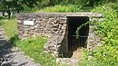
There is an archaeological site at the “Moselle Valley East Viewpoint” rest stop. The remains of a Roman mansion from around AD 200 and a cellar can be found here. The area on the left bank of the Rhine was then a Roman province , namely Germania superior on the Upper Rhine .
The entire original area of the Roman villa, which was already known in 1901, probably had an area of up to 100 × 100 meters. Archaeological excavations and investigations were only started in 1971, when the motorway and bridge were being built. Only the remains of the manor house to the east of the motorway have been preserved. The area of the main house visible today, which includes the structurally separate basement or storage room, is around 30 × 30 meters.
Due to the location of the Moselle slope, it is assumed that wine was grown and that there was a winery on the estate ( Villa rustica ).

- Roman mansion

Site plan of the manor house

Preserved, southeast-facing part of the Roman villa on the Moselle valley bridge

North-east partial area of the Roman villa on the Moselle valley bridge
Storage or cellar room of the Roman villa


See also
Web links
- State Office for Mobility Rhineland-Palatinate
- Data and images in the bridge web
- Moselle valley bridge (A 61). In: Structurae
- Moselle valley bridge (A 61) on Highestbridges.com
- Roman estate near Winningen
- Roman estate Winningen / Mosel
- Roman villa on the Winninger Bridge
- State Mobility Office Rhineland-Palatinate: Winninger Brücke celebrates its 40th birthday. In: www.lbm.rlp.de. State Office for Mobility Rhineland-Palatinate, accessed on December 18, 2016 .
annotation
- ^ Marko Kiessel: Reports on archeology on the Middle Rhine and Moselle 11, special print from: On the construction of the basin in an outbuilding of the villa rustica von Winningen , Society for Archeology on Middle Rhine u. Mosel eVu of Archaeological Monument Preservation, Koblenz Office 2006 (online)