
Wittlicher Senke cycle path
| Wittlicher Senke cycle path | |
|---|---|
|
|
|
| overall length | 30.8 km |
| location | Eifel , Moselle / Rhineland-Palatinate |
| map | |
| Link on map | |
| Starting point | Wittlich |
| Target point | Silence on the Moselle |
| Places along the way | Dreis , Salmtal , Sehlem , Esch , Hetzerath |
| Flooring | paved throughout |
| Height difference | Start 160 m , end 130 m max. +75 m up / −120 m down |
| difficulty | Max. 4% incline; slightly hilly |
| Traffic volume | Bike path; seldom roads with little traffic. |
| Connection to | Maare-Mosel-Radweg , Mosel-Radweg , Kylltal-Radweg |
| Website URL | www.moseleifel.de |
The Wittlicher Senke cycle path is a cycle path that leads from Wittlich through the fields and meadows of the Moselle Eifel to the Moselle town of Schweich . It connects the Maare-Mosel-Radweg with the Moselle-Radweg and the Kylltal-Radweg , as well as the Roman city of Trier , which is only a few kilometers away . The route leads on paved, well-marked paths through the slightly hilly terrain of the Wittlich valley . Its location, protected by the surrounding mountains, makes it possible to grow tobacco here . The route, which is uniformly marked with the bike path logo in both directions, is also easy to cope with for recreational cyclists.
Route Wittlich - Schweich
Route description
In the historic old town of Wittlich , the cycle route branches off from the Maare-Mosel cycle path and heads west, slightly uphill to Hof Breit. In the following depression it crosses the A60 motorway ( Belgium - Rhine-Main area ) and reaches the town of Dreis with its baroque parish church of St. Martin and the castle . Then it follows the Salmtal , crosses the Moselle railway line in the village of Salmtal , then continues near the A1 motorway before turning off to Sehlem . It then leads past Esch towards Hetzerath . A wine museum can be visited in Hetzerath. The route between Dreis and Esch runs together with the Salm cycle path . The route passes Hetzerath and the Föhren industrial park , which borders the Trier-Föhren airfield , before reaching Schweich and thus the Moselle cycle path . On it's Trier km reached in about 12th
Elevation profile
| kilometre | section | Length / km | + Hm up - Hm down |
|---|---|---|---|
| 0 | Wittlich - Hof Breit | 3.1 | +80 |
| 3.1 | Hof Breit - Dreis | 5.1 | −60 |
| 8.2 | Dreis - Salmbrücke ( Esch ) | 5.7 | −60 |
| 13.9 | Salm Bridge - Sehlem | 1.3 | +10 |
| 15.2 | Sehlem - drinking water. Station R1 | 1.6 | −20 |
| 16.8 | Drinking water Station R1 - Esch | 0.4 | +20 |
| 17.2 | Esch - Rivenicher fountain | 2.5 | −15 |
| 19.7 | Rivenicher fountain - Hetzerath | 3.9 | +75 |
| 23.6 | Hetzerath - Schweich | 7.2 | +60 |
| 30.8 | Keep quiet | - |
Connecting cycle paths
The Wittlicher Senke cycle path is a connecting path through the Wittlich region from the Maare-Mosel cycle path in Wittlich to the Moselle cycle path towards Trier. It shares the route to Esch with the Salm cycle path that starts in Dreis . At its end point in Schweich, it also has a connection to the Kylltal cycle path .
see also:
Train and bus connections
The Hauptbahnhof Wittlich lies on the Mosel route Koblenz - Trier and is operated by the hour.
The “ Regioradler Vulkaneifel ” RegioLinie 300 bus runs as a cyclist bus between Bernkastel , Wittlich and Daun . These buses run daily from April 1st to November 1st and have space for 22 bicycles.
Landscape and culture
The Wittlich Senke is the continuation of the Trier Valley in a north-easterly direction. It is not only recognizable as an elongated depression in the landscape , but can also be described as a basin in terms of its geological structure . It runs parallel to the Moselle and is separated from it by the ridge of the Moselle mountains . It is bounded by the Meulenwald in the northwest and the Kondelwald in the east . The fact that the route is still not entirely flat is due to the fact that the watershed between the Moselle and the Salm has to be overcome. Due to the sheltered location, the climate, similar to the Moselle valley, is mild and relatively dry. The landscape is mainly characterized by meadows. Tobacco cultivation can also be found, favored by the mild climate. After a slight ascent, the route leads to Dreis in the Salmtal. After leaving the Salm near Esch , the route crosses Hetzerath and the Föhren industrial park before reaching Schweich through the vineyards.
Attractions
- Wittlich : old town with market square; Old town hall with municipal gallery for modern art ; former synagogue ; Roman villa ( see also: List of cultural monuments in Wittlich ).
- Dreis : Baroque Church of St. Martin; Lock .
- Salmtal : Salmmühle from 1838 as well as numerous renovated farmhouses; Dörbach district with baroque mills belonging to the Klausen monastery.
- Sehlem : village square; Ensemble of parish church St. George, rectory and old school from the classicism period .
- Esch : church; Mill; Village square; Village well with the frog spouting water.
- Hetzerath : Parish church of St. Hubertus and rectory, wine museum
- Schweich : ferry tower ; former synagogue ; St. Martin Church; Stefan Andres Fountain; the Niederprümer Hof is closely related to the Imperial Abbey of Prüm .

Old town hall in Wittlich
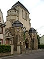
Former Wittlich synagogue

Niederprümer Hof on the eastern edge of Schweich
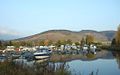
Boat harbor in Schweich

Ferry tower in Schweich


literature
- ADFC regional map Eifel / Mosel , 1: 75,000. Bielefelder Verlag, 1st edition 2006. ISBN 3-87073-391-8
- Cycle Atlas Cycle Atlas "South Eifel" - between the Ardennes and the Vulkaneifel , 1: 75,000. Esterbauer publishing house. ISBN 978-3-85000-269-1
Web links
swell
- Radwanderland.de , accessed November 2011
Coordinates: 49 ° 58 '47.6 " N , 6 ° 53' 57.9" E